Hurricanes – Looking back and looking ahead

Hurricanes – Looking back and looking ahead

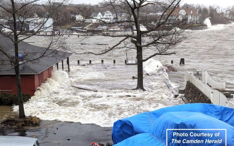
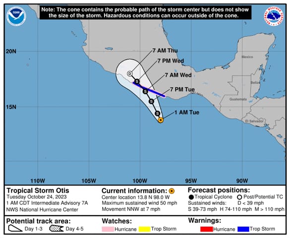
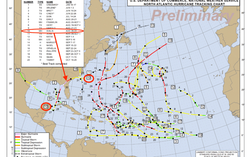
The World Meteorological Organization (WMO) recently announced the entrants to the “Hall of Fame” for the 2023 season. It’s not really called the Hall of Fame, but rather it is the WMO Hurricane Committee deciding which names will be retired from the previous season and not used again moving forward. The retirements of names occurs when a system is unusually impactful. Typically this means that the system was quite strong, and that it also impacted a large population. Occasionally, though, a system’s name can be retired even if it was not an unusually strong system, but its impacts were still…
Read More
Coastal Flooding

Coastal Flooding

Among the hazards for those living or working in immediate or near coastal areas is that of coastal flooding. Coastal flooding occurs when ocean water moves into coastal areas, and is fundamentally different from flooding due to heavy precipitation, sometimes termed fresh water flooding. Fresh water flooding can occur in any area, but is more likely in low lying areas and near rivers or streams, not necessarily near the coast.  There are two major factors to consider when assessing the risk of coastal flooding. The first is the state of the tide, and the second is the presence of strong…
Read More
Rapid intensification of hurricanes

Rapid intensification of hurricanes

by Ken McKinley In the previous newsletter I discussed the impact of upper level wind shear on hurricanes and how its presence or absence impacts changes in intensity of these systems. Thanks to significant improvements in the ability to observe these systems as well as the environments around them, mostly due to more sophisticated weather satellites and better mathematical modeling, there have been dramatic improvements in forecast accuracy over the past couple of decades. However, there is one aspect of tropical cyclone forecasting which has lagged behind in terms of improvement, and this is the phenomena of rapid intensification (RI).…
Read More

Vertical wind shear and hurricanes

by Ken McKinley   There is much more information disseminated about hurricanes today than there was a generation ago, which is a good thing. Back then, forecasts were not as accurate as they are today, and were generally sent only as text products. With widespread internet connectivity still in the future a generation ago, most members of the public and voyaging mariners got their information about hurricanes and their threats from radio or television reports. Some television meteorologists would generate graphics to show their audience, but they were not as sophisticated as they are today. These days the amount of…
Read More

Maui wildfires and Hurricane Dora

by Ken McKinley During the second week of August 2023 catastrophic wildfires have occurred in the Hawaiian Islands. The fires have been most severe over western portions of the island of Maui, and the town of Lahaina has suffered near total destruction in some areas. Many news reports have cited Hurricane Dora as the primary cause of the development and rapid spread of the Hawaiian wildfires, but this is not the case. Lahaina has been a significant yachting center for cruisers and racers in recent years and has a rich maritime history. Unfortunately there has been significant loss of life…
Read More

2023 Atlantic hurricane season and storm reanalysis

by Ken McKinley The official start of the Atlantic hurricane season is June 1st each year, but this does not mean that tropical or subtropical cyclones cannot occur before this date. Historically the peak of the season occurs later in the summer and into the early autumn, and it is not unusual to see long periods of no activity early in the season, though in recent years the first tropical system has shown up in either May or June. 2023 has been no exception as the first tropical cyclone of the season (Arlene) formed in early June. This system began…
Read More

Freddy’s Long, Strange Trip

Tropical Cyclone Freddy set records as it traversed the Indian Ocean and impacted Madagascar and portions of southeastern Africa in February and March of 2023. To start looking at this system, I suggest viewing the following video produced by the National Environmental Satellite Data and Information Service (NESDIS): https://www.nesdis.noaa.gov/news/tropical-cyclone-freddy-breaks-records-lashing-madagascar In fact, it is worth viewing the video before continuing to read this newsletter. The video lasts just under two minutes, and there is accompanying text on the web page which is also worth reading. The video shows the extraordinary track of Freddy as it made its way across the southern…
Read More

Weather window for crossing the Drake Passage

In the northern hemisphere as we move toward the winter solstice, our counterparts in the southern hemisphere are approaching their summer solstice with the longest day of the year on the way. At the highest latitudes of the southern hemisphere, this is the time of year when ocean voyages are possible. In particular, it is possible to get to Antarctica, and there has been an increase in both commercial and recreational passages in this part of the world in recent years. Even at this time of the year, though, passages in these areas come with significant risks. In fact, a…
Read More

Rocks in the Pond

Almost everyone is familiar with what happens when one tosses a small rock into a calm pond. The rock displaces the water level where it impacts the pond, and as the water level rebounds toward the equilibrium level, waves are generated which propagate away from the point of impact in concentric circles. This is a manifestation of the energy that the rock imparted to the surface of the water. A similar phenomena applies when tossing a small rock into the ocean, but the difference is that most of the time, the ocean is not calm, and waves already exist. In…
Read More
Dogwood and Cactus

Dogwood and Cactus

The title might suggest that this newsletter will be about flowering trees and desert succulents. Rather, the title refers to two new supercomputers that NOAA placed into service in late June of 2022. These computers are twins, meaning that they have nearly identical capabilities so that when one needs to be taken down for maintenance or upgrades, there is no loss of operational capability. They are located in separate parts of the country, again, allowing for redundancy in the case of some sort of an issue at one of the sites. They are some of the fastest computers in the…
Read More