
by Ken McKinley
In the previous newsletter I discussed the impact of upper level wind shear on hurricanes and how its presence or absence impacts changes in intensity of these systems. Thanks to significant improvements in the ability to observe these systems as well as the environments around them, mostly due to more sophisticated weather satellites and better mathematical modeling, there have been dramatic improvements in forecast accuracy over the past couple of decades. However, there is one aspect of tropical cyclone forecasting which has lagged behind in terms of improvement, and this is the phenomena of rapid intensification (RI). RI is defined as an increase in the maximum wind speed of a tropical cyclone of at least 30 knots within a time period of 24 hours or less.
The factors that allow for RI are generally known, and include low wind shear (as noted in the previous newsletter), well established upper outflow channels, a location over warm ocean waters, and no dry air anywhere within the circulation of the system. However it has been difficult to determine which combination of these parameters will definitely lead to an RI situation.
One of the mathematical models meteorologists use to help in forecast tropical cyclone intensity is the SHIPS model. The acronym stands for Statistical Hurricane Intensity Prediction Scheme. This model provides guidance for predicting the intensity of systems only, in other words, it provides no input about the future track of a system. As such, it is based on atmospheric and ocean parameters of the system itself, and also includes some input from climatological (i.e. historical) data. It has proven over the years to be a reasonably good tool — except for rapid intensification situations. Given that this model is focused solely on intensity, it has been used as a basis for developing a Rapid Intensification Index (SHIPS-RII). This index was first used in 2001 as an internal tool at the National Hurricane Center and has been refined and expanded in the intervening years. It should be noted that the SHIPS model itself almost never explicitly forecasts rapid intensification, and the various versions of the SHIPS-RII assign a probability of RI occurring.
In more recent years, other dynamical models that forecast the full fields of pressure and other parameters in the tropical regions have been evaluated for their ability to forecast RI. Some of these models have shown limited ability to forecast RI. This is termed probability of detection (POD). Unfortunately these forecasts have also come along with a fairly high false alarm rate (FAR), meaning that there is a significant portion of the time when the model predicts RI but it then does not occur.
For those who are interested in a deeper discussion of the history of RI and the tools that have been developed to attempt to forecast it, a scientific article packed with statistics, charts and graphs can be found at this link: https://www.mdpi.com/2073-4433/12/6/683
By definition, a tropical cyclone that undergoes RI will lead to rapidly deteriorating conditions in its location. Because the skill at forecasting RI is not that high, situations can arise where conditions along the forecast track of a tropical cyclone end up being much worse than forecasts indicated as little as 24 hours after a forecast is issued. This situation occurred in connection with hurricane Otis in the eastern Pacific in October of 2023.
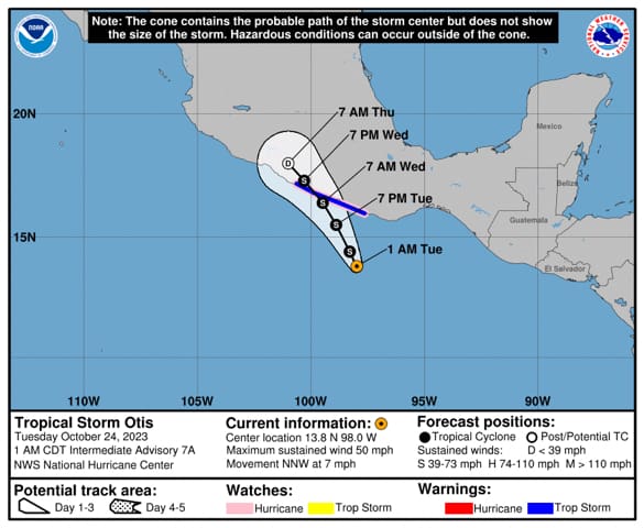
Otis had a rather short lifespan, but a very damaging one. A tropical depression formed well south of the coast of southern Mexico on Sunday morning, October 22. The system became tropical storm Otis Sunday afternoon, then strengthened slowly through Sunday night and Monday while moving slowly north-northwest. By 01:00 CDT on Tuesday the system had top sustained winds of 45 knots, and was forecast to continue moving north-northwest and reach the coast of Mexico at Acapulco as a strong tropical storm within 24 hours. Figure 1 shows the graphic forecast at that time.
Just a few hours later at 04:00 CDT Otis had strengthened with top sustained winds of 55 knots and the forecast showed more significant strengthening in the coming days and now indicated that Otis would be a hurricane when it made landfall at Acapulco. In the previous newsletter, I mentioned the availability of the forecaster’s discussions on the National Hurricane Center website. To recall, this is a product where meteorological factors affecting the projected strength and track of tropical cyclones are discussed in scientific terms. Since RI is difficult to forecast, even when there is a chance that it could occur, it will often not be explicitly included in a forecast due to the inherent uncertainty. These are situations when accessing the forecasters discussion can be very useful. Here are some excerpts from the forecaster’s discussion issued at 04:00 CDT on Tuesday, October 24, 2023 (bolding added):
It appears that the vertical shear over Otis has decreased as there has been an expansion of the cirrus outflow over the eastern portion of the storm. The shear is expected to remain light to moderate while Otis moves over SSTs of 29-30 degrees C during the next day or so. These conditions should allow for continued strengthening as Otis approaches the southern coast of Mexico. The latest NHC intensity forecast calls for Otis to become a hurricane today, and it shows additional strengthening before Otis reaches southern Mexico in a day or so. The NHC intensity forecast is at the high end of the guidance in best agreement with the HWRF and HAFS-B models. The SHIPS Rapid Intensification Index now shows about a 1 in 4 chance of rapid strengthening during the next 24 hours, which supports being on the higher side of the guidance.
Six hours later, Otis had strengthened only a bit more with top sustained winds at 60 knots meaning it was still a tropical storm, and the following sentence was included in the forecaster’s discussion:
The SHIPS Rapid Intensification (RI) indices show a greater than normal probability of RI, so some further upward adjustments to the intensity forecast are possible later today.
Rapid intensification occurred in the following six hours and at 16:00 on Tuesday Otis was a category 3 hurricane with top sustained winds of 110 knots. From the forecaster’s discussion at this time:
Otis is forecast to be an extremely dangerous Category 4 hurricane when it reaches the southern coast of Mexico late tonight or early Wednesday, and preparations to protect life and property should be rushed to completion.
Just three hours later, a special forecaster’s discussion was issued including the following:
Otis is forecast to be a potentially catastrophic Category 5 hurricane when it reaches the southern coast of Mexico late tonight or early Wednesday, and preparations to protect life and property should be rushed to completion.
At 10 PM on Tuesday, the following was included in the forecaster’s discussion:
A nightmare scenario is unfolding for southern Mexico this evening with rapidly intensifying Otis approaching the coastline. Satellite images show that Otis has continued to intensify, with estimates between 130-145 kt during the past few hours. The initial wind speed is set to 140 kt as a blend of these values, making Otis a Category 5 hurricane. Otis has explosively intensified 95 kt during the past 24 hours, a mark only exceeded in modern times by Patricia in 2015.
This is an extremely serious situation for the Acapulco metropolitan area with the core of the destructive hurricane likely to come near or over that large city early on Wednesday. There are no hurricanes on record even close to this intensity for this part of Mexico.
The impact of Otis at Acapulco was indeed catastrophic when it made landfall just after midnight Tuesday night with top sustained winds of 145 knots. Recovering from this system will likely take years.
The almost unbelievable intensification of this system over a very short period of time left the Acapulco area massively unprepared for what occurred. Consider that the forecast depicted in Figure 1, issued at 1AM on Tuesday, suggested that there would be a strong tropical storm (just short of hurricane strength) making landfall at Acapulco, but not 24 hours later Acapulco was dealing with a category 5 hurricane centered right over them.
Given that the skill in predicting RI in tropical cyclones is limited at this time, as shown rather dramatically in this situation, what steps can be taken by those who could be affected by these systems?
First, never stop paying attention when tropical cyclones threaten your area of interest. Pay close attention to every advisory, and keep watch for any special advisories that may be issued. In this case, the forecasters were playing catch-up as they witnessed the unprecedented situation develop in real time, particularly between 10:00 and 16:00 when the rapid intensification was most extreme, and several special advisories were issued.
Second, access the forecaster’s discussions. Even if rapid intensification is not explicitly forecast at a given time, the forecasters may refer to the possibility in their discussion, and this can provide an early warning that conditions may end up being worse than anticipated. In this case, the forecasters first mentioned the RII in their discussion at 04:00 Tuesday, and it was followed up in subsequent discussions through the day, which conveyed the increasing possibility of a catastrophic impact.
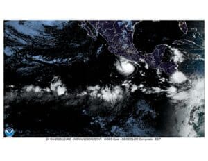
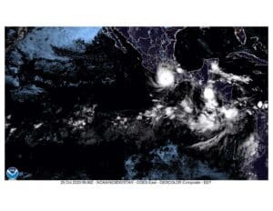
Figure 2 is a satellite image of Otis at 07:00 CDT Tuesday when it was a tropical storm with top sustained winds of 60 knots. Figure 3 is a satellite image of Otis just prior to the time of landfall when it was a category 5 hurricane with top sustained winds of 145 knots. Note that Figure 3 is only 17 hours after Figure 2.
Contributing editor Ken McKinley is a weather router and the founder of Locus Weather in Camden, Maine.