Tropical Cyclone Freddy set records as it traversed the Indian Ocean and impacted Madagascar and portions of southeastern Africa in February and March of 2023.
To start looking at this system, I suggest viewing the following video produced by the National Environmental Satellite Data and Information Service (NESDIS): https://www.nesdis.noaa.gov/news/tropical-cyclone-freddy-breaks-records-lashing-madagascar In fact, it is worth viewing the video before continuing to read this newsletter. The video lasts just under two minutes, and there is accompanying text on the web page which is also worth reading.
The video shows the extraordinary track of Freddy as it made its way across the southern Indian Ocean after developing near Indonesia on February 5, 2023, and the accompanying text indicates that as Freddy made landfall in Madagascar, it held the record for the largest Accumulated Cyclone Energy (ACE) for any single system in the southern hemisphere. ACE is a parameter which is often used to measure the severity of an entire hurricane season, but it can also be used to compare the energy released by single storms, particularly when they have a long duration. In the case of Freddy, by the time it reached Madagascar on February 21, 2023, having tracked all the way across the Indian Ocean, it had already been in existence for 16 days, and for much of that time it was a major hurricane (category 3 or higher). Its strength and its longevity contributed to the record ACE value. For comparison purposes, the only Atlantic hurricanes on record with higher ACE values were an unnamed hurricane in 1899 and hurricane Ivan in 2004.
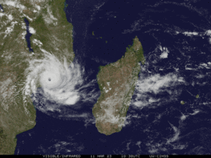
Figure 1 is a satellite image from the Meteosat Satellite of Freddy early on February 21st prior to the Madagascar landfall.
As extraordinary as the trek of Freddy across the Indian Ocean was, and notwithstanding the records that were already set as the storm crashed into Madagascar on February 21st, in some sense the long and strange trip of Freddy (apologies to the Grateful Dead) was really just getting started.
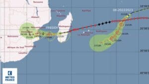
As Freddy moved across Madagascar it was weakened by its interaction with the terrain of the island, and it emerged over the Mozambique Channel on February 22nd and continued west as a tropical storm, making landfall in southern Mozambique on February 24th. Figure 2 shows the track of Freddy through the southwestern Indian Ocean and over Madagascar through February 22nd, and its forecast by Meteo France to reach the coast of southern Mozambique on the 24th. Note that there was another tropical system present farther to the east in the southern Indian Ocean at this time, but it was forecast to dissipate by February 27th.
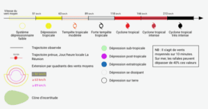
Figure 3 shows the legend of symbols for the Meteo France charts. For comparison purposes, 63 km/hr is equivalent to 34 knots, which is the threshold for a tropical storm. 118 km/hr is equivalent to 64 knots, the threshold for hurricane strength. 166 km/hr and 213 km/hr are equivalent to 90 and 115 knots, respectively. The threshold for a Category 4 hurricane is 113 knots.
Freddy did make landfall as forecast over southern Mozambique as a tropical storm on February 24th, and then weakened as it moved west-southwest through the following 24 hours. By the 25th, it was classified as a tropical depression, and it then meandered northwest for a couple of days, ending up in southern Zimbabwe by February 27th. Then it began to move toward the east-southeast, maintaining its circulation, and, remarkably, it moved back across the coast of Mozambique on March 1 in almost the same spot where it made landfall several days earlier. For the next couple of days it moved generally east over the Mozambique Channel. It regained tropical storm strength on March 4th and approached the southwest coast of Madagascar later on March 5th. Its motion then become slow and a bit erratic for a day or so, but it continued to strengthen, and by early in the day on March 7th, it had regained hurricane strength.
Freddy then began to move northwest, and there were some fluctuations in intensity, but eventually the system made landfall in central Mozambique on March 11th as a hurricane with top wind speeds of 102 knots, a category 3 system. It then weakened while moving northwest through Mozambique and finally dissipated on March 14th over southern Malawi, more than a month after it first developed.
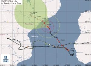
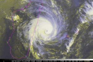
Figure 4 shows the track of Freddy from the time it moved from Madagascar into the Mozambique Channel through its first landfall in Mozambique, its return across the Mozambique Channel for a second approach to Madagascar, and its northwest track back across the Mozambique Channel as a hurricane. Its position on March 10th is shown, along with the forecast for the second Mozambique landfall. It is almost necessary to put your finger on the chart to trace the extraordinary track of this system! Figure 5 is a satellite image of Freddy just prior to landfall in central Mozambique on March 11th.
By the time all was said and done, Freddy set several records. Recall that as Freddy made its first landfall in Madagascar, it had already set a record for the highest value of the ACE parameter for any single system in the southern hemisphere. When Freddy’s trek was finally complete, it had recorded the highest ACE parameter of any known tropical cyclone worldwide. This means that this system released more energy than any other tropical cyclone in history. Freddy was also the longest lasting tropical cyclone on record, existing for more than five weeks.
Freddy impacted several areas, including the islands of Mauritius and Réunion in the Indian Ocean, as well as Madagascar, Mozambique, Zimbabwe, Malawi, South Africa and Zambia. Fatalities are known to have occurred in all of these areas except Réunion, South Africa, and Zambia. The most significant loss of life occurred in Malawi where extremely heavy rains led to severe flooding. It is not uncommon for the greatest loss of life connected with tropical cyclones to occur in connection with fresh water flooding produced by heavy rain, so even though Malawi is a landlocked country, and Freddy’s winds had dropped off well before the system arrived there, the rainfall was devastating.
As the start of the hurricane season approaches for the North Atlantic and the eastern and central Pacific, this is a good time to review hurricane action plans and make sure that all resources are in place well in advance of any possible need.
Contributing editor Ken McKinley is a professional weather router for both commercial and recreational clients via his company Locus Weather in Camden, Maine.