There is much more information disseminated about hurricanes today than there was a generation ago, which is a good thing. Back then, forecasts were not as accurate as they are today, and were generally sent only as text products. With widespread internet connectivity still in the future a generation ago, most members of the public and voyaging mariners got their information about hurricanes and their threats from radio or television reports. Some television meteorologists would generate graphics to show their audience, but they were not as sophisticated as they are today.
These days the amount of information easily available to the general public is staggering, and this allows the public to be much more informed about these systems, and to be able to take action well enough in advance to mitigate their threats. With internet connectivity improving for those on the high seas in the more recent years, much of this information is now available at seas as well. One of the products now generally available is the forecaster’s discussion. This is a product that was only shared among government agencies and professional meteorologists. It is where meteorological factors affecting the projected strength and track of systems are discussed in scientific terms. These factors are now regularly included in news reporting about a system, and some of the terms have become quite common in use, but still may not be well understood by the general public.
One such term is “upper level wind shear.” For those who pay attention to the forecaster’s discussion, or listen to news reports that quote it, or watch television meteorologists who use the term, it is generally understood that upper level wind shear is not conducive to the development or strengthening of tropical systems, and can lead to their weakening. But why? And what does it really mean?
Let’s start with a definition. Wind shear is, very simply, a change in wind velocity with distance. Keep in mind that velocity includes both direction and speed. When we speak of upper level wind shear, we are indicating that there is a change in wind velocity in the vertical. In other words, as one goes up in the atmosphere, one encounters a change in wind velocity. Usually this means an increase in wind speed at higher altitudes.
Vertical wind shear is common in the middle and high latitudes, but in the lower latitudes, upper level winds are, on average, lighter. In fact, for tropical cyclones to develop, upper level winds in the region of development need to be very light and uniform through all levels of the atmosphere. This is because the center, or core of a tropical cyclone is made up of strong currents of rising air that produce thunderstorms, and these thunderstorms generate a tremendous release of heat into the atmosphere due to the condensation of water vapor, and this is the main energy source for these systems. These upward motions need to be able to persist for a significant period of time and through much of the depth of the atmosphere in order for a tropical cyclone to develop and strengthen. When this occurs, an upper level outflow pattern becomes established, which acts as a sort of vent for the top of the circulation and allows the process to persist. This upper level outflow pattern needs to be vertically aligned with the low level circulation of the system for intensification to occur.
When stronger winds are present in the middle or upper atmosphere (upper level wind shear), they disrupt the upper level outflow pattern and also prevent the pattern of rising air through the entire atmosphere from being established. Other ways of thinking about this are visualizing strong winds “punching a hole” in the vertically rising air currents, or having the strong winds “blow the top off” a system. Basically, these stronger winds do not allow the processes that are required for tropical storm or hurricane intensification to continue, and so when encountered, they will either halt intensification, lead to weakening, or perhaps even dissipation. If the stronger winds are present in the earliest stages of potential tropical cyclone development, they may not allow a system to ever develop a circulation that leads to intensification.
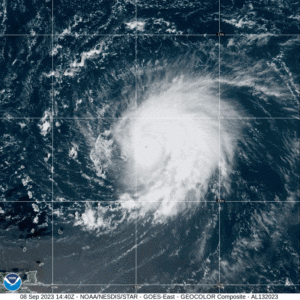
We can examine two systems from the 2023 Atlantic hurricane season to help illustrate these concepts. Figure 1 is a satellite image of Hurricane Lee when it was a category 5 hurricane. The eye of the hurricane is visible as a dark spot near the center of the image surrounded by solid cloud cover known as the central dense overcast, produced by strong, deep upward air motion. Looking carefully at the image, it is possible to see bands of clouds spiraling in toward the center of the system. There are a few larger, more prominent bands to the east of the center which are bands of very intense thunderstorms. Another feature to notice is what appear to be thin wispy clouds radiating outward from the center away from the mass of thicker clouds. These wispy clouds are particularly noticeable to the north and northwest of the center, and they represent well established upper level outflow. In this situation, little or no upper level shear was present, which allows the outflow to be well established.
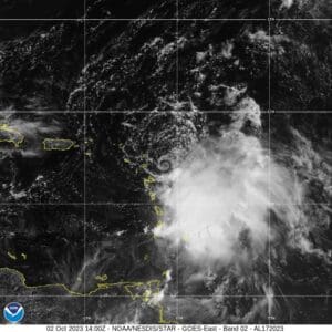
Figure 2 is a satellite image of Tropical Storm Philippe when it was near the northern Leeward Islands. In this situation significant upper level shear was present with persistent moderate upper level winds from the northwest. This resulted in poor upper level outflow for this system and the disruption of the vertical alignment. Examining the image, the center of Philippe is clearly seen as a small low level swirl of clouds with all of the brighter clouds (representing the thunderstorm activity) displaced to the southeast of the center. Even though there were some strong winds around the center, and some strong thunderstorms off to the southeast, this system was not intensifying at this time. There is no upper level outflow evident to the north and west of the system, and upper level outflow to the south and east is not well organized, which is a sign that upper level shear is impacting the system. There is no central dense overcast surrounding the center of the system showing the lack of deep upward motion in that area.
It is somewhat ironic that the strongest weather systems on earth are so fragile in the early stages of development. All it takes is 25 to 30 knots of upper level winds over a system to prevent its development or intensification, as was the case with Philippe, which never reached hurricane strength despite being over very warm ocean waters. At the time of the image in Figure 1, there was virtually no upper level shear associated with Lee which allowed it to reach category 5 status. In the following days, some upper level shear did impact Lee and led to weakening.
Contributing editor Ken McKinley is a weather router and the founder of Locus Weather in Camden, Maine.