In the northern hemisphere as we move toward the winter solstice, our counterparts in the southern hemisphere are approaching their summer solstice with the longest day of the year on the way. At the highest latitudes of the southern hemisphere, this is the time of year when ocean voyages are possible. In particular, it is possible to get to Antarctica, and there has been an increase in both commercial and recreational passages in this part of the world in recent years. Even at this time of the year, though, passages in these areas come with significant risks. In fact, a cruise ship recently encountered some very rough conditions in the Drake Passage, the stretch of the Southern Ocean between southern Argentina and Chile and the Antarctic peninsula. Unfortunately, there was some damage to the ship, some passengers were injured, and one lost her life.
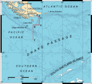
There is a major difference between the two hemispheres in the regions between latitudes 50 and 70 degrees. In the southern hemisphere, there is very little land in these latitudes, it’s almost all ocean. The southern end of South America (including Cape Horn) extends to about 55° S or so, and the Antarctic peninsula extends north to near 65° S making the Drake Passage the narrowest portion of the Southern Ocean around Antarctica. Otherwise the Antarctic continent extends only a bit north of 70° S in portions of the eastern hemisphere and, other than a few small islands, the closest significant land to Antarctica other than South America is New Zealand, whose South Island extends to about 47° S. This lack of land in the high southern latitudes has consequences for weather and sea conditions.
Low pressure systems in the southern hemisphere tend to be more intense during the winter months, just as they are in the northern hemisphere. These lows tend to track generally from northwest to southeast from the middle latitudes to the high latitudes, and they can become quite intense during the winter months. This leads to very strong winds with the prevailing wind direction from the west. This does not mean that other wind directions do not occur, but rather that westerly winds prevail. With these persistent winds, the seas can grow extremely large, mainly because there is no land in the way to stop growing waves. The lows are not as strong in the summer, but gales are not at all uncommon, and the prevailing wind direction is still from the west, meaning seas can still be rather high, though not as high as in the winter. However, there is also a better chance of finding a window with reasonable winds and seas to cross the Drake Passage, though seeing gales during at least some portion of the crossing is still a good bet.
The persistent westerly winds year round in high southern latitudes give rise to the Antarctic Circumpolar Current, also known as the West Wind Drift. This current flows in a clockwise fashion around the Antarctic continent following the winds, and it is the only major ocean current in the world that loops back upon itself. Other major ocean currents are interrupted by the continents, but the Antarctic Circumpolar Current flows uninterrupted, and this helps it to become quite strong. In fact, it is the strongest current in the world.

Another issue in the higher latitudes is ice. There are two types of ice that are of concern. The first is sea ice, which is frozen ocean water. This is much less of a concern in the summer, but can still be a problem closer to Antarctica and among its islands, particularly earlier in the warm season. The second type is icebergs, which are fresh water ice, and originate from the glaciers and ice shelves of Antarctica. Because of the strong Antarctic Circumpolar Current, most icebergs do not move very far north away from the continent before getting caught in the current and being transported eastward. Thus icebergs in the southern hemisphere do not make it to the same low latitudes that they do in the northern hemisphere.
So for ocean voyagers who are looking to make a passage across the Drake Passage in the summer (really the only time possible) consideration needs to be given to the strong current that will be encountered, to the fact that storms can still track through these waters in the summer and can still produce some very difficult conditions, and also to the possibility of encountering ice.
A good source for information in this part of the world is the Chilean Navy Weather Service. Its website provides weather forecast information for all of Chile’s coastal and offshore waters, extending from the northern portion of the country in tropical latitudes south to the Drake Passage and the Antarctic peninsula. In addition to text forecasts, the website has links to satellite images, model data, ice analysis, and also to other sources of data.
Let’s look at two images from the web site. The first is a surface chart from December 15, 2022 (Figure 1). This chart shows high and low pressure centers along with fronts and isobars, much like the charts which we have often looked at for the northern hemisphere. Note that highs are designated with an “A”, and lows with a “B”. Troughs of low pressure are labeled with a lower case “b”. There is a notable low on the chart well to the west-southwest of Cape Horn where the isobars are quite close together indicating strong winds. The pressure gradient is not as steep in the Drake Passage, so wind speeds there were not as strong at this time. There is a geostrophic wind scale at the lower right of the chart which allows the wind speed to be derived from the spacing between the isobars. This scale is easier to use on the black and white version of the chart because it is clearer. In any event, this scale would suggest sustained wind speeds around the low of between 50 and 60 knots. Winds north of 60 degrees south in the Drake Passage at the time of this chart would be around 15 knots, a relatively quiet day for this part of the ocean. The presence of lighter winds does not necessarily mean that conditions are favorable, though, as sea states could still be fairly high making it difficult for a sailing vessel to keep the sails filled due to vessel motion caused by the seas.
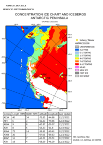
The second image is an ice chart (Figure 2). The colors on this chart show the concentration of sea ice around the Antarctic peninsula (land area shown as white) and over portions of the Drake Passage. On this chart, valid on December 2, 2022, much of the Drake Passage was ice free but significant sea ice was present to the east of the Antarctic peninsula over the Weddell Sea. The chart also shows the location of large tabular icebergs, which are generally rectangular in shape and are the result of chunks of ice shelves around the continent breaking away. The table at the bottom of the chart gives locations and details for these icebergs.
As with any other ocean passage, a voyage across the Drake Passage requires a great deal of preparation and study in advance of the passage, but some of the issues noted above are unique to this particular passage.
Contributing editor Ken McKinley is a professional weather router for both commercial and recreational clients via his company Locus Weather in Camden, Maine.