by Bill Morris
 Staying on course under sail, particularly within 100 miles of any coast, is a lot easier with a modern, GPS-controlled chartplotter. With the latest generation of chartplotters, you can navigate to virtually any point on the world’s oceans while staying on course and out of harm’s way.
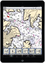
To start off, there are two types of digital charts: raster and vector. Raster charts are digitalized copies of paper charts, such as those published by NOAA and the British Admiralty. On the other hand, vector charts are purely digital, capable of changing the amount of chart detail depending on zoom level.
A new chartplotter will have either raster or vector charts covering North America, including the Hawaiian Islands, Mexico and the Caribbean. Sailing beyond familiar waters to the South Pacific and around the world will require a set of extra electronic or paper charts covering those areas.
Maptech offers raster charts (digitalized versions of NOAA paper charts), which include extensive detail of your cruising grounds, regardless of elevation. The advantage of Maptech’s charts is being able to keep an eye on shoals and small islets strewn across such areas as the Marshall and Tuamotus islands during a Pacific crossing, regardless of how much you zoom in or out of the chart.
If there is a disadvantage of a raster chart, it is the extent of visual information you see, irrespective of the degree of zoom. On the other hand, some mariners prefer seeing all the details of a given route when studying large areas of ocean for route planning rather than leaving the fine-tuning of navigating around hazards until actually arriving at those areas.
Vector charts, like those available from Navionics, Garmin and C-Map, are fully digitalized charts, layered to reveal increasing detail as you zoom in on a given area. The advantage here is being able to map out the basic route of an ocean passage before zooming in on such details as shoals, coral reefs, small islands and sunken ships, which could pose serious hazards to navigation.
On a small chartplotter screen, trying to focus in on a dense collection of map details might be too distracting to be of much help in route planning. The screen on my Garmin 64cv chartplotter is only slightly larger than my iPhone 12 screen, but with the vector system, the Garmin is easy to read at any elevation.
The most expedient way to add or update both raster and vector charts on a chartplotter is with a pre-loaded microSD memory card, available from Raymarine, Lowrance, Navionics and other major electronics manufacturers.
Raymarine Lighthouse Charts boast high clarity, along with what Raymarine calls “maximum readability, intuitive navigation and superior nautical chart quality.” With a Raymarine online subscription, you can download marine charts for use onto a microSD card for your chartplotter, laptop or tablet.
Lowrance’s C-Map chart collection can be downloaded easily onto any Lowrance device, which is also compatible with Navionics cartography.
Digital raster charts are also available free from NOAA, a department of the U.S. government. NOAA regularly updates raster charts to ensure a means of safe navigation for both recreational and commercial mariners.
While sailing offshore, even if you have electronic charts covering your cruising grounds, always remember to carry paper charts as back-ups. Paper charts, such as those published by NOAA, the British Admiralty and Imray, offer extensive detail and may be read even by candle light if the electrical power system fails.
Select the chartplotter best suited to your navigation needs, and sail with confidence in knowing your precise location and course anywhere on the world’s oceans.
Circumnavigator-author Bill Morris believes the best strategy for succeeding as an offshore voyager is to keep systems simple and, if possible, manual. Key to survival are a windvane self-steering system, a basic array of electronics and an aggressive alternative energy battery charging matrix. Bill is a an Ocean Navigator contributing editor and the author of The Windvane Self-Steering Handbook (International Marine, 2004) and The Captain’s Guide to Alternative Energy Afloat (Seaworthy Publications, 2019).