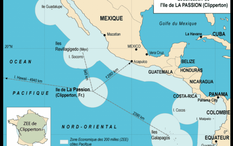
Most Pacific sailors and published cruising guides will tell you there are two ways back to Southern California from Panama: a motor bash 3,400 miles along the coast of Central America and then up along Baja, or out to Hawaii, over the Pacific High to San Francisco, and then down the coast, rounding Point Conception (a.k.a. Little Cape Horn). But there is a third way back: a sail from Panama to California via Clipperton Island with very little motoring.
Jimmy Cornell’s directions in World Cruising Routes take you directly from Panama out beyond Clipperton Island, and then north until arriving in San Diego. However, you can make a couple of stops along the coast southwest of Panama City and up to Costa Rica, shortening the crossing by a few hundred miles before heading out into the open Pacific.
After clearing out of Panama, sail out across the Bay of Panama toward Punta Mala, and then west to Isla Coiba or a bit farther to Isla Parida. Both islands have anchorages where you can spend a day or two before embarking on the offshore voyage. If you want to make one more stop, sail northwest to Quepos, Costa Rica, a quaint but lively town where you can find those last few grocery items before the long slog back to U.S. soil. Though anchorage space is limited, Quepos has a modern yacht marina, so it’s worth a visit if you’re cruising along this patch of coast.
Clipperton
Having cleared out of Quepos, you will head 1,470 nm west by northwest toward the French island of Clipperton, an uninhabited atoll surrounding a fresh water lake.
As you pull yourself away from land, be ready for the possibility of a Papagayo wind to kick up and carry you west and away from shore at an exhilarating pace. Coastal sailing can be fun for a while, with frequent stops for bars and curio shops, but after a few days of constant sail changes and watching for rocks, you will be longing to be hundreds of miles offshore, where there’s room for mistakes and time to sleep.
As you gradually pull away from the coast, you will more than likely encounter soft, shifting winds, which will gradually turn toward the northwest. If you are leaving in late spring, be sure to be north of a line parallel to Cabo San Lucas (30º N) by mid-May to avoid the possibility of tropical storms or even an early hurricane.
A steady northeast breeze will gradually fuel your broad reach west. Once past a point due south of Cabo San Luas, expect the wind to shift to the northwest, putting you close to the wind as you make your westing toward Clipperton.
After roughly two weeks of sailing, you can decide to round Clipperton to the west and turn north, or you can take a few days’ rest at the uninhabited atoll, where you can take on fresh water and plan the remaining voyage to San Diego.
Anticipation
Sailing north against wind and ocean current, you will face moderately rough conditions while tacking back and forth up the Baja coast. Two hundred miles southwest of San Diego, having passed to the east of Isla Guadalupe off Baja California, you should be able to pick up NOAA Weather on the VHF radio. The familiar, computerized voice of home announcing weather “from Point Conception to the Mexican border” will be a refreshing change from the monotony of beating against the wind 24 hours a day.
Once you have reached a point 12 miles offshore from San Diego, call USCG Sector San Diego on VHF channel 16. The Coast Guard will direct you to the police dock in San Diego for clearing-in procedures, even if it’s 0300 in the morning, as it was in my case.
The sail from either Panama or Costa Rica to Clipperton should be pleasant and uneventful. But after you hang a right for California, this will be one of the slowest, roughest voyages you will ever undertake. Take along lots of food, libations and books, and before long, you will be safely docked in San Diego Harbor.