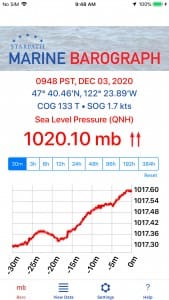
 Having access to marine forecasts and gridded binary (grib) files is great for voyagers. Equally useful, however, is having weather instruments on board so that you can monitor what’s happening with the weather right around your vessel. Real-time local data is an excellent backup to forecasts which focus on the large area macro weather. The Starpath School of Navigation in Seattle recently launched a useful weather app for phones and tablets called Marine Barograph that not only tells you the current pressure but also records it and displays it in graphic format.
One traditional local weather tool is the recording barometer: a barometer linked to an ink stylus that marks on a slowly turning drum of paper. The Starpath app is a digital version of the recording barograph.
This latest app is based on an earlier, free Starpath app called Marine Barometer, which provides pressure data but without the graphic capabilities.
According to Starpath’s David Burch, both Starpath apps are different from many of the barometer apps available because the Starpath apps make use of the iPhone’s own pressure-sensing hardware. Other apps will use barometric pressure from the nearest airport or pressure as reported by the National Weather Service. “This approach is terribly inaccurate for marine work,” said Burch. “Our app is a dependable tool for mariners.”
In addition to graphing atmospheric pressure over time, the app also uses GPS data to calculate course over the ground (COG) and speed over the ground (SOG). The result is that the app acts as a nav data logger. Users can then export that COG/SOG data to OpenCPN or a similar nav program. The free Marine Barometer app is available at the Apple App Store and via Google Play. The new Marine Barograph app is $14.99 at the Apple App Store. n

