In the marina it’s relatively simple to manage communications – a cell phone with a subscriber identification module (SIM) card from the local phone company, and perhaps WiFi supplied by the marina management. This makes it easy to talk with folks distant and obtain relevant weather reporting from internet-based sources. The entire equation changes when you head offshore on passage.
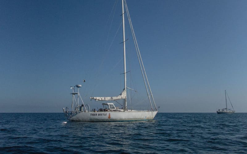
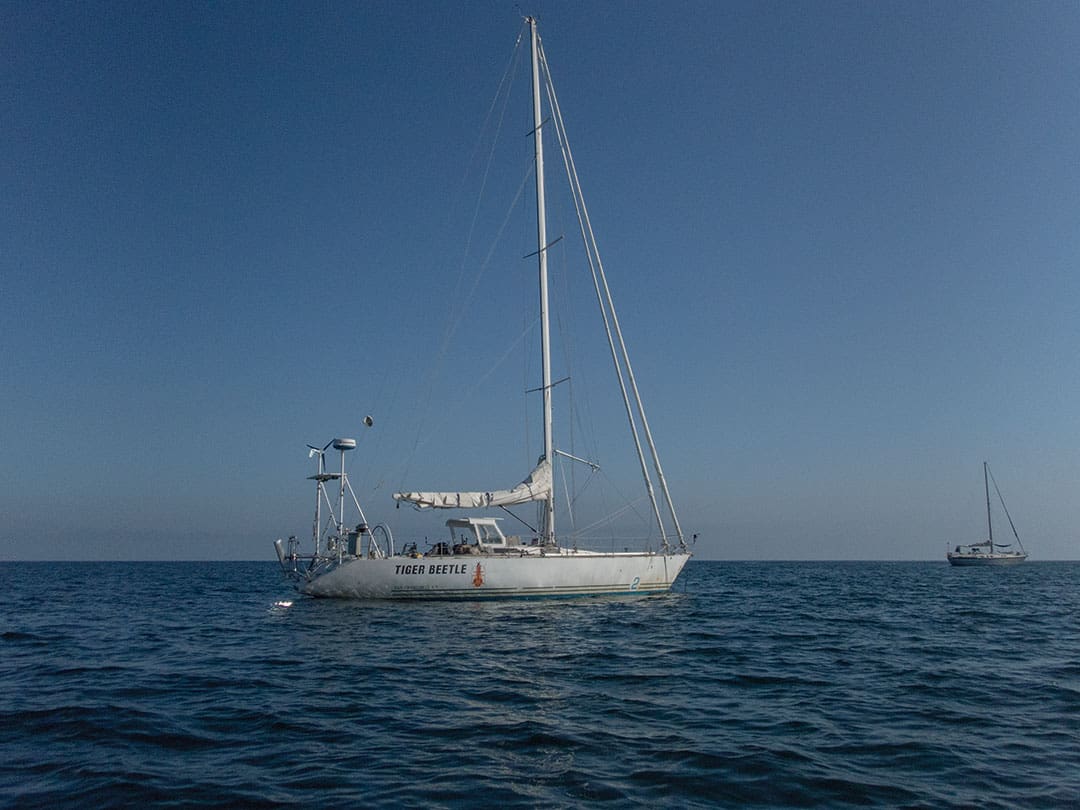
I race and cruise a 45-foot Morgan 1983 N/M 456 IOR two tonner, an older race boat that was well built for offshore use. I’ve raced singlehanded San Francisco to Hawaii several times and actively cruise the west coast of North America to Tahiti. Currently Tiger Beetle is in California and I plan to head south for Mexico. The boat and I are accustomed to 2,000- to 3,000-mile offshore passages lasting several weeks and then fetching up in fairly remote places. I’ve installed equipment with the aim towards functional, affordable, and reliable long-distance communications — which has required upgrading the boat’s battery and charging systems to handle the required loads.
Define requirements
Before looking at equipment the first question is, What capabilities do I want offshore? The answer is determined by what I want to achieve, and a significant portion of the answer is financial. With unlimited funds I’d like an Inmarsat terminal supporting a direct internet connection plus a gigabyte or three per month. At $7,000 and up for the terminal and another $2,000 per month for service that setup is outside my financial abilities.
Back to the question: What do I want from communications offshore? On passage I’m looking for: weather, voice communications with other boats, email to shore, possibly a phone call or two to shore – in that order. I would also like automated position-reporting to shore specifically so my mom can see where her kid is ; this isn’t useful to me as I already know where I am, but it’s important for her, therefore, I’d like a position transponder.
The most important information offshore is weather – both current conditions and forecasts. Twice daily I bring in weatherfax, High Seas text broadcasts, precipitation actual and forecasts when near the equator, sea surface temperature charts, weather model GRIB output, infrared and visible light satellite imagery, among other data. Based on this information I plan where to point the boat for the next 12 hours and revise my route.
I enjoy talking with other boats sailing along my route, and VHF range is insufficient as boats spread out across the ocean during a passage. The best way to keep in contact I’ve found is SSB radio, which requires an organized radio net set up in advance. Sometimes there are established nets I join, other times an ad hoc net is created for a specific passage. It’s helpful to hear reports from boats ahead, what their weather conditions are, and on an approach to a destination it’s useful to obtain first-hand harbor and anchorage reports.
Email to and from shore is a good way to check-in with folks at home, keep up with the news, obtain information about equipment on the boat, and organize parts-ordering when things break. It’s great to arrive in port and find there’s already a package of goodies containing hard-to-find parts waiting for me. Email is also an excellent mechanism for requesting and receiving specific weather data from internet-based sources when used through SailDocs.
Voice communications are difficult to and from shore both with satellite and HF radio, though for different reasons. An HF radio phone patch through a helpful HAM station can be difficult to arrange and signal propagation affects the call clarity. Satellite phone connections are simpler to initiate but conversations are halting due to the significant lag time – it’s not at all like talking with someone over the phone. Background boat and wind noise is problematic for both. I generally place few telephone calls while on passage.
SMS messaging between satellite telephone users is possible, essentially treating SMS as a stripped down version of email sent directly to satphones that one can subscribe to. I prefer to use email to shore and HF radio to boats, keeping my satphone number private.
Determine geographical cruising area
Where, geographically, do I want those features to work? As a simple but local example, when I sail to the southwest side of Santa Cruz Island which is all of 14 miles offshore from Southern California – I might as well be on the far side of the moon. There’s no cellular phone signal, no VHF signal to shore, and there’s no infrastructure on the island. Everything is silent! Kind of fun until I want to know tomorrow’s weather forecast. I can try listening for NOAA weather radio over the VHF if I can pick up a signal far to the south… so I use HF radio or satellite communications to get email weather info to my part of the moon.
VHF works everywhere, is limited to antenna line-of-sight, excellent for nearby contacts but the usefulness falls away quickly on passage. Boats travel at different speeds on different courses, and after 12 hours it’s typical for the gang you’d like to stay in touch with to have moved out of range. To reliably talk with a boat further than 30 miles distant requires something other than a VHF radio.
HF (SSB, HAM) radio works everywhere and will reach worldwide, allowing that any given connection is limited by RF propagation between the two radio stations. Propagation directly correlates to distance, time of day of night, and selected radio frequency. SSB communications are normally arranged in advance via a radio net with specific times and frequencies when all net members will meet on the radio. If the radio nets aren’t known prior to departure it is difficult to find them while on passage.
Satellite communications are great provided the boat is located within the constellation’s service area. Satphones are a close model to a shore-side telephone: turn the device on, it usually connects, dial the number, the call rings through. Satellites are always listening and I can initiate a call whenever I choose to, which is beneficial. The principal limitation of a satellite system is the satellite constellation’s “foot print” on the Earth’s surface.
When looking a satellite system examine the footprint to know if constellation coverage includes the expected cruising/passage area. GlobalStar’s low earth orbit (LEO) constellation is primarily aimed at the trucking industry with the satellite footprint extending to a relatively narrow band of water adjacent to the North American coast; GlobalStar does not cover mid-ocean on the way to Hawaii or into the South Pacific, for example. Inmarsat’s geosynchronous earth orbit (GEO) constellation doesn’t quite get the poles, but does cover most everything else of interest to a cruiser. Iridium’s LEO constellation provides truly global coverage.
 Establish shore-side services before departure
Before casting off, there is some groundwork to be taken care of before the various communication services will be useful offshore. Some examples:
Create a private email address for the boat while retaining a public email address. Share the private email address only with people trusted to not flood the inbox with unwanted email traffic, using the public address for all other external email traffic. If the private email inbox fills up with garbage it can make accessing email from onboard unusable — so protect the private email address.
To talk over the radio internationally, at least for a USA-flagged vessel, requires an MMSI, ship’s radio call sign, and a Radio Operator’s Permit. Obtain these through the FCC.
To send/receive email over SSB/Pactor modem requires connection to a shoreside station similarly equipped with a Pactor modem. SailMail is one such service that maintains SSB radios around the world, and I have a SailMail account. HAM radio licensees can also join the WinLink system, an amateur/volunteer system similar to SailMail. WinLink does not have an annual membership cost though the operator must have a HAM license and be licensed to operate in the country the boat happens to be in (an issue for USA HAMs when operating in Mexico, for example).
Satellite services require SIM cards, with airtime usage being pre- or post-paid. Prepaid is a SIM card with a fixed airtime quantity per time period that can (usually) be recharged to extend the life of the card — an example is $500 for 400 minutes of data connect time good for six months. It is important to know how to recharge/extend a prepaid SIM card if usage exceeds expectations. When using prepaid service I like to carry a second low-value prepaid SIM card in case the primary card runs out and won’t recharge over the satellite connection; having a backup SIM card provides a second chance. Once a SIM card is disabled, it’s permanently disabled and without a second brand new unused card I’m stuck. For trips shorter than three to four months a prepaid card makes sense, depending on how much airtime you forecast to use.
Post-paid service is an unlimited SIM card associated with a standing account that incurs a monthly invoice and payment. To manage those payments I keep a credit card on file with the service provider and arrange an auto-payment schedule to cover the cost. It’s critical to have at least one extra SIM card for a post-paid service to keep the satellite connection alive should the credit card be declined by the bank for any reason — such as the card’s Fraud Prevention Services deciding your card has been compromised and inconveniently turning it off for you. One way to minimize this risk is maintain a credit card solely dedicated to making auto-payments for the satellite communications account.
Selecting equipment
The gear needs to fit within the boat’s budget, electrical capacity, and be small enough to actually find a place on board. As a great deal of gear exists, this is where research pays off handsomely — nobody wants to purchase the same thing twice owing to incorrect initial decisions.
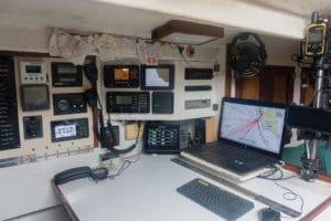
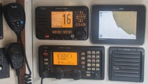
For VHF I want the radio protected belowdecks at the nav station, with a remote station mounted topside in the cockpit. If the remote is damaged, I still have the primary radio available. Mount a vertical whip antenna as high as possible to obtain maximum range for the signal. Power losses in the antenna feed cable are significant, use a low-loss cable such as tinned copper RG-213 or lighter-weight aluminum LMR-400. It’s a good idea to place a DC-DC block and a Gas Discharge Surge Tube in the feed line help protect the radio from nearby lightning strikes.
Furuno and Icom continue to make SSB radios. Couple one of these units with an automatic tuner mounted at the base of the antenna and an insulated backstay or Shakespeare 23-foot half-wavelength vertical whip antenna and the boat has a system that will reach 2,000 to 4,000 miles. Be aware that the microphone is a critical component of the SSB – if the microphone goes out then so does the radio. Carry a spare microphone on board. For email-over-SSB (e.g., SailMail) a Pactor modem connected to a nav station laptop is a good solution. As a licensed HAM I have not carried a dedicated HAM rig, instead I utilize my Icom M802 on both HAM and SSB frequencies.
For satellite communications the constellation choices are fairly limited: GlobalStar if sailing coastally within the GlobalStar footprint, Iridium if crossing oceans and low throughput is acceptable, Inmarsat if the funds exist and higher throughput is needed.
Inmarsat can support relatively fast connection speeds such as FleetBroadband at 150 to 432 kilobits per second (kbps) and is available most places a cruiser is likely to visit, with an expensive airtime cost. 250 kbps is needed to support video conferencing, the 150 kbps is good enough for moving larger files and slow internet surfing. To keep this in perspective, 150 kbps is 166 times slower than a shore-side 25Mb/s broadband internet connection people might use at home. Connection to the Inmarsat GEO satellites requires a relatively large gimballed, powered, stabilized dish antenna mounted on the boat.
Mounting an Inmarsat antenna is a non-trivial exercise. The antenna needs to be placed away from the radar, difficult to do on a small boat unless the antenna is set above the radar. A rigid mount is required with the widest least-obstructed view of the sky possible while reducing antenna roll, pitch, yaw to a minimum. As a result, Inmarsat antennas on sailboats are often placed as the top-most antenna on a stern arch. On a power boat the antenna mount might be on top of the house above the radar. Weight of the dome, mounting pole, and platform is a factor; a Cobham Sailor 150 comes in at 11 pounds in addition to the mounting mast. The dish antenna inside the dome contains motors that operate to back out the boat’s motion, thereby maintaining the antenna’s aim at a fixed GEO satellite overhead. To run those motors the Sailor 150 consumes roughly 120 watts (max) in operation so the ship’s batteries need to be up to the task.
an external
antenna.
Iridium is also a global service and offers a 2.4 kbps service – super slow, sufficient to support voice communications, email, SMS messaging, and relatively inexpensive. Note that while Iridium is 70 times slower than FleetBroadband 150, Iridium does not require a stabilized antenna; instead a simple 4-inch tall fixed helix antenna will connect to the LEO Iridium satellites. This saves power, weight, cost, and simplifies installation. A particularly useful feature of Iridium for cruisers is the “Unlimited Data” prepaid airtime plan – this is a monthly plan providing an unlimited data connection, perfect for downloading GRIB files, accessing email, and even sending small images from the boat through a satellite to shore-side internet. An issue to be aware of with LEO satellites: LEO satellites are not stationary in the sky, instead they are orbiting along and will descend below the horizon as the next satellite in the constellation comes into view – the connection from the boat does not always shift to the new satellite immediately, resulting in a dropped connection. This doesn’t happen all the time, but when it does I have to restart my connection from the boat.
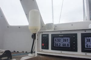
extrnal antenna is mounted under Tiger Beetle’s hard dodger.
For Iridium a fixed-mount external antenna mounted on deck is important. A satellite telephone handset’s microphone picks up wind noise, and the satphone has a small antenna with a signal strength that is further reduced if using the satphone belowdecks. A better solution is an externally mounted larger antenna to which the satphone can be connected. Now I can sit at the nav station to use the satphone with a better signal than built into the satphone, the chart table is a surface I can work on, no wind noise to interfere with the call, and I can wedge into place and get comfortable.
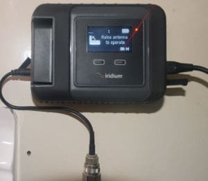
The most useful solution currently on Tiger Beetle combines SailMail’s software and Iridium services to use the best features of each through an Iridum GO! satellite modem. The GO! connects to the Iridium LEO satellite and makes that connection available as a WiFi signal on board. The laptop and SailMail can connect over GO!, along with Iridium’s own applications installed on Beetle’s smartphone on board — the smartphone becomes the satphone handset for when I wish to place a satellite phone call to shore. PredictWind also operates over GO!, along with a short list of other services, though I have not used them. When I can’t get to an Iridium satellite, which happens when anchored near tall cliffs, I often can still make a connection with the SSB/Pactor modem.
Using the equipment
Offshore I maintain a VHF radio watch on channel 16. The Icom M506 is a DSC-enabled radio that accepts incoming calls directed to Beetle’s MMSI number; the MMSI is broadcast by the Vesper AIS Class-B transponder I keep running when offshore. Nearby ships can see my MMSI on their equipment and place DSC radio calls. To date these calls are primarily test-calls so the ships can verify their radios are working, with the occasional call from USCG to ask if I’ve seen flares launched near my position.
The nav station laptop is mounted in place and remains powered-on while on passage (I usually keep the screen closed, the screen consumes the bulk of the power) – I have sufficient charge capability to support the low power Hewlett Packard engineering laptop which runs AirMail for interfacing with the Iridium GO! and SSB/Pactor modem. A Logitech keyboard that stores bluetooth connections makes it simple to point the keyboard at the laptop or Samsung smartphone. With the laptop connected via WiFi to the GO!, I run SailMail’s AirMail software (Iridium-certified to allow operations over the satellites) and send requests through to SailMail’s servers, retrieve email from my shore-based email account, send orreceive weather data through SailDocs, and send or receive from the boat’s private email address. All this is fairly quick, doesn’t use much power, works when I want it to, and makes it relatively straight forward to get information to andfrom the boat.
Keep mom happy
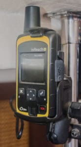
For the position transponder I have an inReach SE (now Garmin) Iridium-based transponder, the subscription is affordable for me and the device sends out an SMS-based text message containing position, time, speed, and course on 10 minute intervals – which is plotted on Garmin’s web site and my Mom can log in whenever she wants to and see where her kid is. This makes her happy! The transponder is mounted belowdecks at the nav station, and I found a location near the nav station where the deck is solid fiberglass (no coring) and the transponder will operate from there when the antenna is positioned up against the deck. This keeps the transponder protected from the elements and plugged in to power.
A nifty feature of the transponder is it’s the only way for a shoreside person to initiate contact to the boat; the inReach SE has a little green LED light that is normally off. If someone on shore sends an SMS message through Iridium to the inReach, the green LED light appears and slowly flashes – the functional equivalent of the telephone ringing. I don’t share that connection much, it’s nice to not have the phone ringing on the boat!
Rob MacFarlane has raced and cruised as a singlehander for 30 years on San Francisco Bay, the West Coast, Hawaii, Mexico, Canada and French Polynesia.