Mariners are quite familiar with tides in most parts of the world, and most probably have a tide table posted on the refrigerator door, in the truck or on board at the nav station. As technology has advanced, there are many apps that provide tide information for multiple locations, so it is easier than it ever has been to keep track of the tides for critical areas.
Tides are defined as the periodic rising and falling of the ocean surface, and they are produced by gravitational forces from the sun and the moon. Because the moon is much closer to the Earth, its gravity is the dominant forcing factor and the sun’s gravity provides only a rather minor contribution. Because the moon takes 27 days to revolve around the Earth, the tides do not occur at the same time every day but rather advance a little less than an hour (on average) each day.
The basic mechanism involved is that when the moon’s gravity is stronger in a given location, it pulls the ocean surface upward (toward the moon). This leads to the ocean surface dropping below a datum level away from this area (about 90 degrees of longitude to its east and west) and this in turn leads to the ocean level rising above the datum level on the opposite side of the Earth. This “forcing” moves around the Earth following the moon’s motion, and the end result is a tidal wave (rising and falling of the water level) that works its way around each ocean basin. The wave peaks at different times around the basin and flows in and out of bays and inlets, which is why high tide does not occur at the same time in all areas.
Because the atmosphere behaves like a fluid, there is the potential for tidal waves to exist there as well. While the tides in the ocean are quite noticeable to anyone who spends any time on or near the water, the atmospheric tides are not as noticeable to most folks unless one is paying very close attention to winds or to a barometer or barograph. The forcing mechanism for tides in the atmosphere is different than that of the ocean as well.
The gravity of the moon acts on the atmosphere just as it does on the ocean, but the impact of the moon’s gravity on the atmosphere is generally insignificant. Because of the differences in density and compressibility between the atmosphere and the ocean, lunar gravity is not able to generate significant waves in the atmosphere. However, tidal waves are generated in the atmosphere due to cycles of heating by incoming solar radiation. For purposes of these tidal fluctuations, the most important heating is that which occurs due to the absorption of solar radiation by the ozone layer. In a process which is too complicated to detail in this newsletter, the heating of the ozone layer during the day and subsequent cooling at night leads to changes in density of the atmosphere, which in turn generates a wave that propagates downward toward the surface and travels around the globe at the same rate as the sun appears to move across the sky. Because this wave is linked to the travel of the sun, this means that the atmospheric high and low tides occur at the same time each day in a given location. It turns out (again, due to physics that are too complicated to detail here) that the most significant wave has a period of half a day, meaning that high and low atmospheric tides occur twice per day.
We now ask, how are these tidal waves in the atmosphere manifested, how are they observed, and what impact do they have? First, the tide is seen in the surface pressure field. There are twice daily peaks and valleys in atmospheric pressure due this tidal effect. These peaks and valleys are best observed in tropical latitudes, and are difficult to observe in the temperate latitudes and the higher latitudes. There are two reasons for this. First, because incoming solar radiation is greater per unit area in tropical latitudes, the forcing for tidal motions is stronger in these areas. Second, because stronger migratory pressure systems are more common in higher latitudes, they frequently mask pressure fluctuations due to atmospheric tides. In the tropics, though, significant pressure systems are not that common, and this means that the pressure changes that occur from day to day are largely due to the atmospheric tide. The big exception to this is the passage of a tropical storm or hurricane.
 |
|
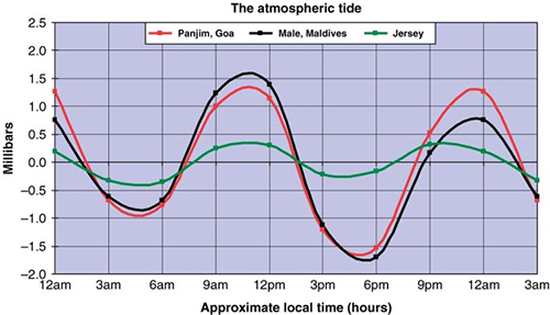
Figure 1: Average pressure fluctuations about a daily mean pressure due to atmospheric tide for stations along the west coast of India (around 15° N), near the equator in the Maldive Islands, and in the English Channel. |
|
Source: Article by Frank LeBlancq in the Journal Weather, Volume 66, Number 11 (November 2011), published by the Royal Meteorological Society. |
Figure 1 presents a graph of pressure fluctuations due to atmospheric tide. For each of the stations shown in the graph, the impact of passing weather systems has been removed to leave just the change in pressure generated by the atmospheric tide, and data through a year or more has been included to provide a long-term average. It is obvious from the graph that the fluctuations are greater in tropical latitudes. In fact, pressure changes of more than 3 millibars every 12 hours are observed in some tropical areas. Pressure maximums occur just before noon and just before midnight with minimums during the early morning and early evenings each day.
 |
|
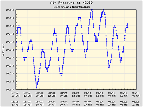
Figure 2: Graph of pressure data from NOAA buoy 42059 (located in the eastern Caribbean at 15° 15’6” N, 67° 30’36” W) from 0000 GMT 7 Aug 2017 through 0000 GMT 12 Aug 2017. |
Figure 2 shows a graph of pressure for several days in early August of 2017 from a weather buoy in the east central Caribbean about 180 miles south-southwest of Puerto Rico. On this graph, the fluctuation in pressure due to atmospheric tide is clearly evident, superimposed on very slight changes in pressure over a period of five days. Note that the pressure minimums occur around 0900 GMT and 2100 GMT each day, which is 0500 and 1700 local time, and this agrees with the general graph shown in Figure 1. Pressure maximums occur around 1500 GMT and 0300 GMT each day, or 1100 and 2300, again about as expected. The change between the maximum and minimum pressure ranges from 1 to 3 millibars.
 |
|
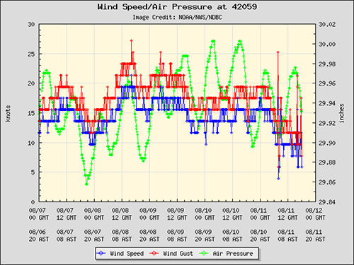
Figure 3: Graph of pressure and wind data from NOAA buoy 42059 (located in the eastern Caribbean at 15° 15’6” N, 67° 30’36” W) from 0000 GMT 7 Aug 2017 through 0000 GMT 12 Aug 2017. Pressure shown in green, wind speeds in blue, and wind gusts in red. |
Figure 3 adds wind information to the pressure graph for the same buoy over the same time period as in Figure 2. Since pressure gradient is a key factor in determining wind speed, it makes sense that there would be a daily cycle of wind associated with the atmospheric tide as well. This graph shows that there is indeed a relationship, but it is not as direct as might be imagined. There is a trend toward stronger winds when the pressure is higher at this buoy, and this may be due to the intertropical convergence zone (a trough of low pressure) is in place to the south over northern South America, a feature that exists due to low level convergence and is less impacted by the atmospheric tide. This means that when the pressure to its north becomes higher, the pressure gradient will become stronger and lead to stronger winds. The impact of the atmospheric tide on winds may be different in other parts of the world depending on surrounding terrain or weather features.
The bottom line is that for ocean voyagers in tropical latitudes, onboard barometers or barographs will show the daily changes in pressure due to the atmospheric tide quite well. If the usual variation is not present, it typically means that a stronger weather feature is approaching the region, like a strong cold front, which is able to push south into the tropics during the winter, or a tropical cyclone tracking toward the region. A daily variation in wind may also be observed, but, depending on location, it is not quite as reliable as the observed changes in pressure.

