When NOAA's Office of Coast Survey (OCS) released its latest National Charting Plan in February 2017, the details it included about chart production apparently drew little comment. Now in a press release the Maptech company, based in New Bedford, Mass. is drawing attention to certain elements in the plan that the company says herald the end of paper chart production. According to the press release, the plan "…calls for ceasing production of the images used to print the charts. The action will have a profound effect on recreational boating." It further quotes the OCS director as reportedly saying, “the paper era is finished." The company is calling on users of paper and raster charts to send comments to OCS via the comment form on the OCS website (link below).
The National Charting plan is available as a 31-page PDF on the OCS site. The plan is broken down into two parts. Part I describes the "Present State of Nautical Chart Production." This section has information on the international carriage requirements for the types of charts commercial vessels are required to carry under international rules, it touches on the customers of OCS charts, explains the types of chart products available, the sources of data and the distribution channels.
Part II of the plan looks to the future and delves into OCS's plans for what it calls "The Transformation of Nautical Chart Production." This section covers anticipated improvements such as chart update policy, improving chart content, improving the chart tiling scheme and improving chart production efficiency.
One small section of Part II contains some language, however, that makes supporters of paper charts, and the raster charts on which they are based, justifiably nervous. This section is entitled "Vision for the Future of Nautical Charting" and includes text about "The End of Raster Nautical Charts (sunset of paper charts). The text of the section states:
"The reduction or elimination of traditional paper nautical charts seems likely as the use of digital raster chart data in ECS increases:
• Individual large scale paper charts will be replaced by the seamless NOAA RNC tile service
• The need for RNC and paper nautical chart "new editions" will be eliminated as the currency of nautical data will be maintained through weekly updates of RNCs
• The currency of nautical data will be identified through the chart tile metadata, not by an edition number
• Only smaller scale overview charts will be available from NOAA certified chart agents to provide mariners with a voyage overview and to support backup for ECDIS
"The reduction or elimination of ALL raster chart coverage seems likely as the use of ENCs in ECS increases:
• The NOAA RNC tile service may be replaced with a vector chart tile service based on ENCs
• Use of ENCs may completely replace raster charts of any form (RNC, RNC Tiles, Paper)"
Lee Estes, president of Maptech, which provides digital charting products and printed chart products such as chart books and print on demand charts, said the company didn't grasp the significance of the National Charting Plan, partly because it was rolled out without any press releases or other notice. "What started out as something we didn't know much about," Estes said, "Is now much more serious than we initially took it."
Maptech says in its press release: "NOAA's Raster PDF images are the sources for publishing print products that are widely used by coastal recreational boaters in conjunction with electronics, such as waterproof charts, chartbooks and cruising guides. NOAA also proposes to eliminate the electronic raster nautical chart (also known as BSB) files that are used by many software systems and navigation plotting systems.
"The change sought by NOAA is due to its use of Electronic Nautical Chart (ENC) data, which consists of layers of vector data designed for use in expensive commercial Electronic Display Information Systems (ECDIS). The ENC database is designed for commercial use and does not contain all of the detail available in NOAA paper charts or raster nautical charts (RNC) in areas that are not frequented by commercial vessels."
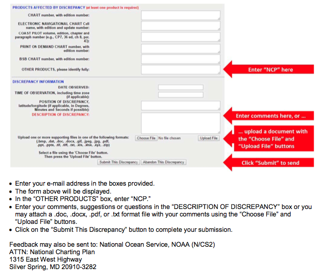
Maptech's press release is a call for users of charts to make sure they weigh on what Maptech is calling the elimination of paper charts. You can go to this site and make your comments. A graphic of how to make your comments is shown below. The comment period ends on June 1, so you will need to make your comment soon.