It was dark with a dimensionless blackness that comes at sea on a starless, humid night. Oddly Enough’s stern faced swells and rising wind. We’d been meeting them head-on an hour earlier when we left the breakwater that sheltered the harbor at Samana on the east side of the Dominican Republic. They had been the cause of our turning back instead of plowing eastward to the Mona Passage. We couldn’t see, just feel them. The blanket of black meant nothing reflected back at us, and like most of the islands we had visited, navigational marks were far apart and their purpose not easily deciphered. We were using radar to navigate our return.
We exited this harbor in late afternoon, hoping to follow Bruce Van Zant’s instructions for a thornless crossing of the Mona Passage to Puerto Rico. Van Zant is big on night sailing to take advantage of island effects that lighten the easterly winds, which blow steadily year-round. We had enough light to get to Cayo Levantado and its shoals before dusk, and our general weather outlook was good. But once out of the shelter, I wasn’t feeling good about the trip, uncertain about the reefs in the dark. Now we were slipping back into the harbor, going on my helming instincts, backed up by radar, having been out this way just a few hours earlier.
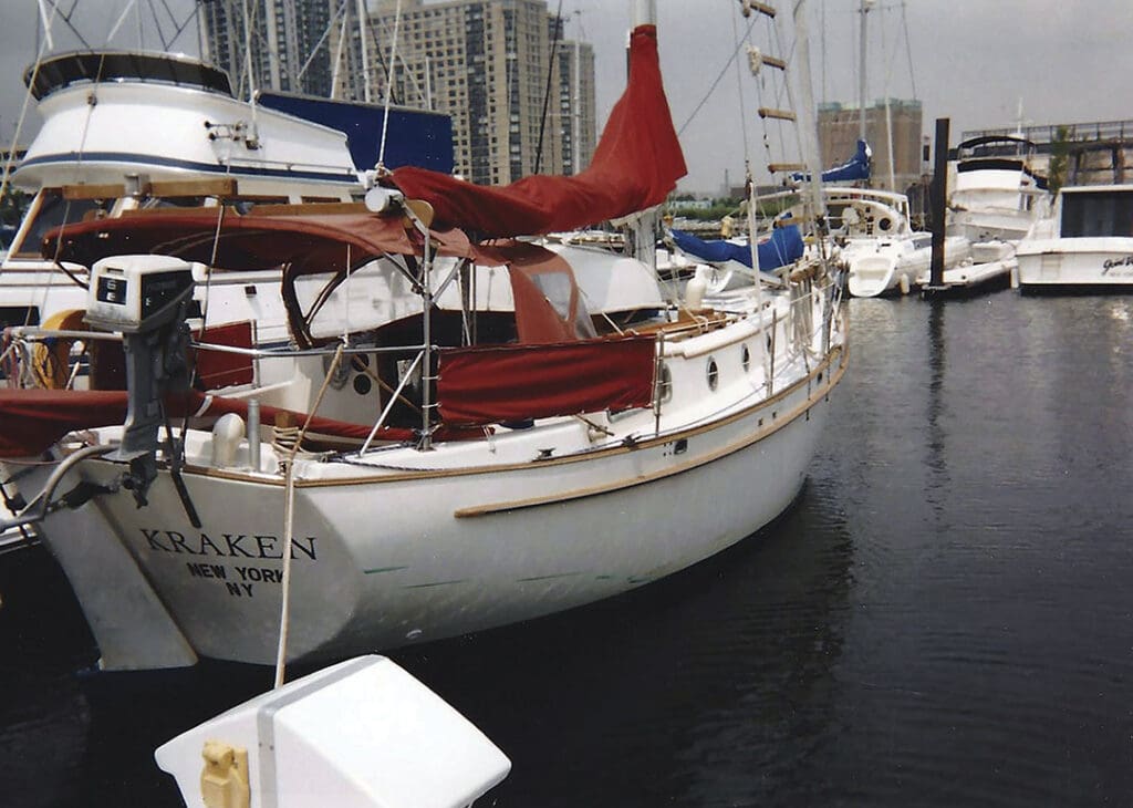
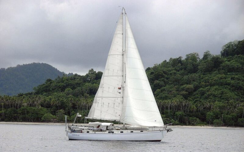
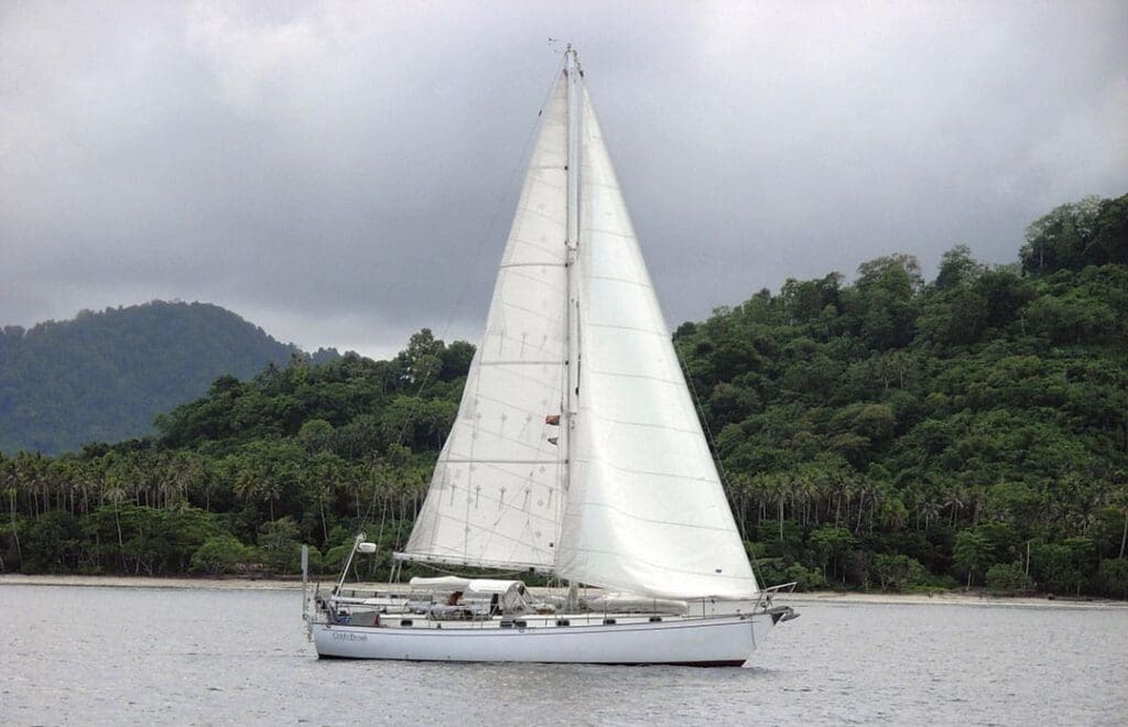
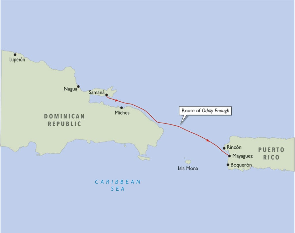
The Mona Passage is a major feature on a cruise from the U.S. East Coast to the Caribbean, except for boats that go offshore or in rallies. Known to cruising sailors as the Dreaded Mona Passage, it runs north-south, separating the East Coast of the Dominican Republic from much smaller Puerto Rico. Though 70 nautical miles wide at its narrowest between Cabo Engaño and Punta Higuero, the distance to travel between ports is much greater. Tom and I had already crossed once on Kraken, our Kaiser Gale Force 34, and now we were getting to the Caribbean in time to enjoy the islands before hurricane season and at the start of our worldwide cruise on Oddly Enough, our Peterson 44.
The Mona is typical of an ocean passage in that it connects significant bodies of water. The Northwest Passage connects the Atlantic and Pacific Oceans, the Drake Passage runs between South America and Antarctica and connects three oceans, and the Windward, Anegada and Mona passages connect the Atlantic with the Caribbean Sea. A lot of water flows through them, helping to make for treacherous sailing under certain conditions, especially in the Mona where the bottom is very uneven.
Choosing a good window for the dreaded Mona Passage helps remove some of the uncertainty of the trip. At 18 degrees north, we were in the northeast trade wind belt. The wind direction varies from southeast through east to northeast, depending on the weather, but the wind going to Puerto Rico in the Mona is virtually always going to be against you, except in storms. Those interested in a comfortable trip can hang out in Samana, watch the wind cycles and wait for the trades to ease up in speed before leaving.
My parents were flying into Puerto Rico in a week, and we had agreed to travel together on land. As cruisers well know, making promises like this can lead to trouble. Because Tom and I had gotten ourselves on a schedule, we didn’t have the luxury of waiting in Samana for a good weather window. On the trip down through the Bahamas from Florida, we’d had excellent luck; since leaving Georgetown, Exumas, the trades had died away and we motored southeast for days, expecting each hour for the wind to pick up. It never did, meaning we didn’t have to tuck behind islands to wait for weather or dodge strong headwinds underway. But by the time we reached the northeastern tip of the Dominican Republic, our diesel supply was low. Hence the stop in Samana to refuel.
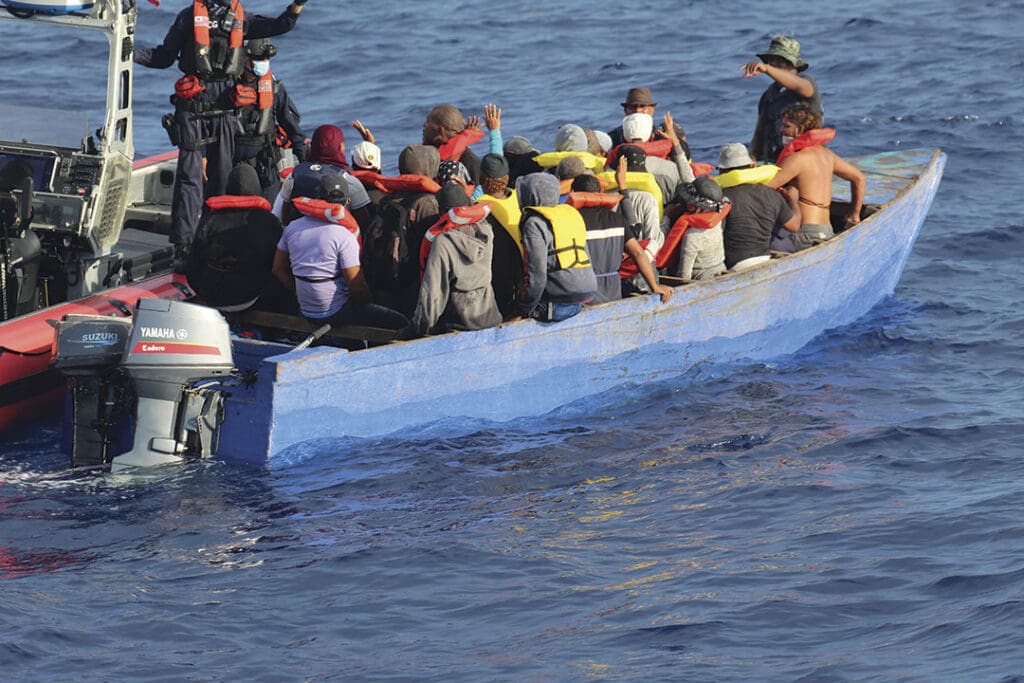
Another group of boaters also cross the Mona without the luxury of a weather window. They are illegal immigrants who leave the Dominican Republic in the dead of night in “yolas,” flat-bottomed wooden boats with single outboard motors. Yolas are similar to pangas, the fiberglass skiffs often seen in the tropical regions that cruisers travel, originally designed by Yamaha as part of a World Bank development project. Yolas are between 19 and 30 feet long, maybe up to 40, designed and built by fishermen in Puerto Rico and the Dominican Republic to launch off their beaches. “Yola” is Spanish for yawl, but boats built today are powered by engines. The yola passengers crammed into them are mostly Dominicans, some Haitians, and all are seeking a better life in the U.S.
Migrants using small boats often make the news. Currently, many of the stories highlight people trying to cross the channel from France to the UK, most of them from Iran, Albania, Iraq, Afghanistan and Syria. A steady stream of people crosses the Florida Straits from Cuba to the U.S., and the Mediterranean has its share, crossing from Africa to Europe. Because of the shifting nature of political and economic fortunes in home countries and destinations, the migrations move in waves.
The first recorded illegal trip from the Dominican Republic to Puerto Rico took place in 1972 when immigration surged following the assassination of Dominican dictator General Rafael Trujillo in 1961. The Dominican population in Puerto Rico peaked in 2010, and for a decade, Mona crossings declined as Puerto Rico became less attractive, battered as it was by hurricanes, earthquakes and a devastating financial and economic crisis that led the government to bankruptcy. Then pandemic-era restrictions and crises in Haiti led to an uptick in crossings by Haitians after 2020.
The Puerto Rican economy appears to have turned a corner, and forecasts of labor shortages in various sectors are leading to another rise in the number of boat trips of Dominican citizens. From Oct. 1, 2023, through Jan. 31, 2024, the Coast Guard carried out 24 interdictions of 780 non-U.S. citizens, mostly from the Dominican Republic, and in February another 71 migrants picked up by the crew of the Coast Guard cutter Joseph Doyle were repatriated to the Dominican Republic. Even Boat Watch has been keeping track and in April of 2021 reported an abandoned yola named Aomema showing signs of having been drifting for a long time.
Nobody knows exactly how many people cross the Mona in yolas. The Coast Guard knows only of the ones they interact with—when something goes wrong and they are called up, or wreckage appears, or abandoned migrants are found on an island, or a worried family member calls to report an overdue yola. Many yolas also successfully cross, and their passengers may be able to meld into the Puerto Rican side if not caught. Although Dominican migration developed mainly due to sociopolitical and economic factors, personal relationships and social networks established with friends and family help to propel migration.
The immigrants don’t make the trip on their own recognizance. Smugglers do the arranging, charging from $500 to $4,000 for a crossing. Even $500 is a huge amount, considering that in 2023 the minimum wage in the Dominican Republic was US$250 per month. Those who can’t pay up front are expected to work to pay off their debt and are vulnerable to sex trafficking. The immigrants must travel light, and they are usually not given life jackets, water or food for a trip that can take from a day and a half to three or four days. The yolas are built quickly, specifically for the trip, and not for long-term use. The Mona Passage crossing is roughly 110 nautical miles from Miches, a common point of departure for yolas outside Samana Bay, which is 125 miles from Nagua on the northeast coast. In reality, the trip can expand to many more miles than these straight-line distances would indicate.
On Oddly Enough, the return to Samana left us absolutely no wiggle room. We anchored well out from the wharf near the breakwater to signal to officialdom our intention to be transient and got a good night’s sleep. In the morning, we had a second visit from the official who had cleared us out the day before and arranged a water taxi to collect our empty fuel jerry jugs so we needn’t go ashore. He now said we could forgo another despacho as long as we left that day, so at 0900, off we went. This time we had the mood-lifting that daylight gives, but our inability to pick a weather window put us in the same situation for this trip as immigrants whose yola captains left the country when their boats were built—at the mercy of whatever conditions came our way.
Kraken made a much more conventional trip to the Caribbean eight years earlier, leaving Fort Lauderdale for a night crossing of the Gulf Stream then taking three months to island-hop from the Abacos through the Bahamas. We then made the final overnight sail from Big Sand Cay south to Luperón, where we left the boat in the care of a friend to return home for the holidays. In the new year, we made easting along the Dominican Republic’s north coast, following Van Zant’s advice to take advantage of the night lee. As we had no timetable we needed to meet, we hove-to outside Bahia de Samana and in morning light anchored off the crowded government dock and were promptly cleared in by the comandante’s crew, who came out to see us.
After a few weeks of sightseeing, we left Samana on Kraken at 1620 in the weakening trade winds, carried on east for an hour to pass the shoals around Cayo Levantado, then turned southeast across the mouth of the bay to the foul ground off Miches on the mainland. From there, we followed the gentle arc of the DR coast, staying in the calm of the land’s night lee until early morning. A night lee is the thermodynamic effect of differential heating and cooling of land and sea. Land cools off much faster than the ocean after a day of heating. At night, warm air over the ocean rises and colder land air flows out at the surface to take its place, creating an offshore wind. In the tropics, the offshore wind can be quite significant, holding back or even replacing trade winds. Coasting along toward Cabo Engaño on Kraken, we encountered winds of less than five knots, and even when we broke away from the coast at dawn for the actual crossing, the light wind held. There were big ocean swells, but with her full keel, Kraken under motorsail swept up and down them easily, and it was a good passage.
Unlike Kraken’s calm passage, once Oddly Enough passed outside the shelter of the breakwater, the full force of 15 to 18 knots of trade winds from the east southeast hit us, and with two reefs in the main, we slogged eastward under motor. Off Punta Balandra, a pod of whales greeted us, spouting and sounding, the morning sun sparkling off their exhalations.
Oddly Enough crashed heavily forward, making hard-won progress until evening, when the seas lay down, the trades eased, and we had a fast, night motorsail until at sunrise we passed Isla Desecheo and turned southeast to approach the Puerto Rican coast in steadily rising wind. We also missed the night lee on this coast, which we enjoyed by arriving after midnight on Kraken. I can remember the last several hours just muscling Oddly Enough as close to directly into the wind as she would motor and still keeping some wind in the main. The seas were uncomfortably close together and hit from a variety of directions, but mostly we plunged bow-on through them, causing the occasional spray to douse Oddly’s side decks. It was totally against Van Zant’s advice, and Kraken could never have done it, but once through the cut in the reefs into Bahía Boquerón, it all lay down. Sailing this part of the route by daylight, we were lucky not to encounter afternoon thunderstorms, which often build up off this coast and break off to roam out over the coastal sea.
Conditions like this in the Mona can be uncomfortable for a well-found cruising yacht but become dangerous for an overloaded open boat driven by a single outboard engine. The real unpredictability of the region comes not from the steady winds but from the movements of the water. A complex seafloor morphology results from a mix of oceanographic and tectonic forces that are actively forming and reshaping the landscape. Part of the North Equatorial Current flows over this uneven terrain into the Caribbean through the Mona Passage. Seas can build seemingly out of nowhere, especially around places like Cabo Engaño, where the ocean heaps up to cross a wide bank. Water that seems deep to a small boat can cause surface chaos, as indicated by the depths of five to 20 fathoms reported on the bank seven miles south southeast of Cabo Engaño, where strong tide rips and heavy swells are visible for many miles. It takes effort to avoid the bank on a direct crossing. Samana Bay has uneven banks on all sides and across any course. On the east side of the Mona, an extensive bank extends from the west coast of Puerto Rico, extending along the route to Mayaguez and Boquerón. There are also three small uninhabited islands. The largest, Mona Island, is a nature preserve with resident rangers but no fresh water.
Despite the winds and seas, crossing the Mona for us had its magical moments. In the middle of the passage, a pair of what looked like either female humpbacks or minke whales dove back and forth under Kraken’s keel for almost an hour, showing us the white undersides of their fins and bellies, which looked blue in that incredibly clear water. And a single dolphin came to play on the last morning and escorted us to Puerto Rico.
Isla Desecheo is a landmark for sailors turning toward Puerto Rico. “Island of Junk,” as my logbook calls it, looked rough in the morning light from Oddly Enough—360 acres of rugged rock rising to 683 feet. It is only 13 miles from Rincón, the closest point on the Puerto Rican coast and not a place of entry for cruisers; the only official one on the west coast is Mayaguez. However, it might as well be on the moon when smugglers drop people off. In May 2022, at least 11 people died and 38 others were rescued off Desecheo when their boat capsized. Under these circumstances, the U.S. Coast Guard is charged with saving people and also figuring out what to do with them. Had they made it by yola to Rincón, they still might not have survived, as many others attempting to make the landing there have died in the surf, which makes this northwest corner of Puerto Rico a mecca for American surfers. Safety risks for women on the boats is very great, and migrants who get tossed into the sea to swim to the islands risk drowning, shark attacks and even greater exposure than that on open boats.
On both Kraken and Oddly Enough, after our day-and-a-half crossings, we had the luxury to head to secure ports where we could drop anchor, rest and clear into Puerto Rico legally.