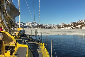
In early May 2015 there was still snow on the ground in Halifax, Nova Scotia, as we prepared our 52-foot steel cutter Bagheera for her next voyage. Our destination was Sitka, Alaska. Since we love the Arctic, we decided the most sensible way to get to our new home port was the 8,000-mile journey via Greenland and the Northwest Passage.
The weather looked favorable for the first few days of the 1,200-mile first leg to Nuuk, Greenland, but the ice edge north of Newfoundland was still a couple of hundred miles wide. This meant that we had to make a 400-mile detour up the east coast of Newfoundland to avoid the sea ice and reduce our risk of encountering large icebergs. We had a nice downwind run for the first 36 hours and then a 25- to 30-knot beam reach with slightly uncomfortable waves. One of the crewmembers became incredibly seasick and asked us to stop in St. John’s, Newfoundland, so that he could fly home. From his viewpoint, the trip was a success and he thanked Erik for saving him from spending a lot of money getting his 40-foot cruiser ready for offshore sailing.
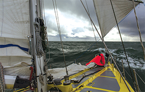
Sailing north from St. John’s, we enjoyed some glorious but cold days until the wind started to increase. At first, the wind stabilized at 30 knots, but after a few hours it continued to build. It was not the most ideal course, nor the safest, as both the wind and seas were coming beam-on, but it remained manageable and the waves did not throw us around too badly. The seas remained regular as the wind stabilized in the low 50s, and Bagheera settled into an “enjoyable” speed at 9 knots. Erik was standing watch under the hard dodger when a massive wave appeared to windward. There was just enough time for him to call out to the crew to take cover before Bagheera heeled over on the flank of the wave. Everything was covered in white water as the wave broke right on top of us and the boat rolled over with her mast underwater. It took only seconds to come upright again and the movement was so elegant that one of the crewmembers slept right through it. Luckily no one got hurt and there was no damage, but the chaos inside was incredible. None of us could have guessed how much of a mess olive oil, flour, rice, pasta, sugar, salt, hot sauce, vinegar and maple syrup can create when mixed on the cabin floor. There was no doubt that Bagheera should leave the cooking up to her crew.
Two weeks of boat work
We arrived in Nuuk early in the morning while the town was still fast asleep. When we left Nuuk two weeks later, nonskid had been added to the deck, the anchor chain was re-marked, a new heater loop was installed along with new seals on windows and hatches, and a new fuel filter system for heater and engine were in place.
 |
|
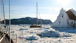
Bagheera pushing through 10/10th brash ice as seen from Snow Dragon II. |
By July we made it to Disko Bay where Bagheera was joined by Snow Dragon II, a Koopmans 49. They came from Halifax as well, but due to other obligations they could only leave a month later than Bagheera. For the rest of the season, the boats sailed together and Krystina, Erik’s girlfriend and co-skipper of Snow Dragon II, split her time between the two boats, even swapping boats mid-ocean as conditions and crew allowed.
Thousands of small, medium and large icebergs filled the waters of Disko Bay but left enough room for navigation between them. The weather was perfect, with the usual summer presence of the permanent high-pressure system providing warm, sunny days and no wind. A few miles out of Ilulissat, we encountered a humpback whale that was bottom feeding. The whale showed no interest in us, or the fishing boats sailing in and out of the harbor. The show continued for hours, and at one point the whale came close and dove only at the last moment.
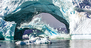
The next morning, just a few miles out of Rodebay, we encountered an enormous arch iceberg. The hole in the berg was at least 100 feet high and 150 feet wide. We have never seen an iceberg with an arch large enough to sail through — if only bergs were not so unstable.
The many cracks in the berg suggested it would collapse at any moment. After a few hours of waiting, our patience paid off, and a couple of hundred tons of ice fell off the arch into the basin underneath.
With not a breath of wind, conditions were perfect to attempt an alternate route to Vaigat. Worst case, we would have to turn around and go through the traditional route recommended by the pilot books.
 |
|
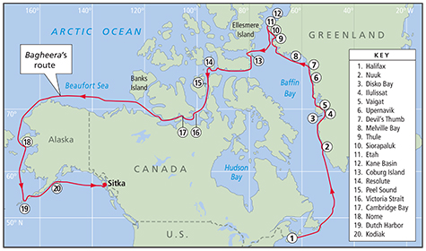
Since the authors love voyaging in the Arctic, they chose the Northwest Passage route, with an extensive visit to Greenland, to get from Halifax to Sitka. |
Further north
North we went — the objective was to pass through a string of islands that were uncharted and only roughly described in the pilot. When we approached the chain, the water was chock-full of brash ice and bergy bits. Sea ice cover is expressed as a ratio between ice and water and, in this case, we carefully avoided the biggest blocks and pushed our way through 10/10th ice. Bergy bits might not be full-size icebergs but they are still a hazard to navigation even in calm weather, and they forced us in a direction that brought us closer to an island than we’d like to be. There was only four feet under the keel and we had to be careful not to hit any of the underwater boulders that are common here. The water continued to get shallower and the remaining couple of inches under the keel disappeared. Bagheera briefly dragged through the mud. We found ourselves in open water but it wasn’t long before we were back in 10/10th brash ice. Except for right behind the boat, we didn’t see any water around us for the next eight miles — that is how compressed the ice cover was.
It was late in the evening when we approached a couple of known anchorages, but they were full of icebergs and we had to look elsewhere. The chart showed a little bay off a river valley; it was not described in any book we had on board, but the anchoring conditions proved to be perfect and the river current kept the ice away for the night.
A few weeks of enjoyable sailing followed and the only downside was the lack of wind. The average wind speed in west Greenland is extremely low in the summer, but the complete lack of sailable conditions was something none of us had seen before. Both the air and water temperatures were unusually high and on one of the hot days we gave in to the temptation and took showers under a waterfall.
Upernavik is usually the most northerly stop in Greenland for boats attempting to transit the Northwest Passage, but we wanted to go further to the Kane Basin. We had another five weeks before the passage opened up, and north Greenland had a lot to offer.
 |
|
A calving iceberg in Disko Bay. |
The narwhal hunt
We arrived in Kullorsuaq, where one of the locals gave us a demonstration of the traditional narwhal hunt with a lot of gestures and sounds, as the only language he spoke was Greenlandic. When he was done showing how his tools work, he came aboard with some of his friends and family and played the guitar and sang us Greenlandic songs. It was a fantastic show and, as a thank you, we gave him a harmonica. His eyes were wet with tears when he accepted it and his granddaughter explained to us that his great-grandmother once received a harmonica from a whaling boat that stopped by more than 100 years ago. It was played for generations by his family, but got damaged over time and did not make any reasonable sound anymore. Now their tradition could be continued and, to celebrate, he played a few tunes.
Melville Bay was an experience of its own. We crossed this part of Baffin Bay with the company of Salty, a Bruce Roberts 65 and Snow Dragon. It was flat calm for weeks and there was no swell rippling the mirror-calm water. The closest land was 60 miles away and when dinnertime came, we made the mutual decision to turn our engines off, hang fenders out, tie the boats together and have a three-course meal with the crews of all three boats. Some frivolity followed after dinner when a few of us went stand-up paddleboarding while others jumped in the icy water for a polar plunge at 75° N.
Windiest in the Northern Hemisphere
While passing Cape Alexander, the westernmost point of both Greenland and Europe, we saw ice glare on the western horizon. That meant that the ice edge was only five to six miles away. Littleton Island appeared to be the bottleneck and if we wanted to anchor for the night we had no choice but to go a few miles south to Etah. Many polar expeditions in the old days used Etah as a basecamp, as it is one of the few somewhat-protected places in the area. However, it was not a great place to anchor; the water is either too deep or too shallow and it is the windiest place in the Northern Hemisphere, according to our pilot.
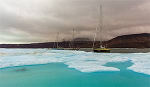
We tried all the anchoring locations described, but none of them were viable because of ice floes or wind direction. Eventually we found ourselves an anchorage on a ridge in the middle of the bay. After a few hours of sleep, we woke to find the bay slowly filling with ice. We pulled anchor and headed out of the fjord only to discover that our exit was blocked by an enormous sheet of sea ice stretching across the mouth of the fjord. The presence of the ice sheet greatly improved our mooring situation at Etah. Erik jumped onto the ice with his ax to create a little channel so that we could anchor to the ice sheet. Once Bagheera was secured, he walked a few boat lengths along the edge of the ice and chopped out another hole so that Snow Dragon could moor there in the same fashion, and then did the same for Salty. With three boats moored to the ice edge, we christened it the “Etah Marina” — complete with being able to step off the side of the boat onto the ice and go for a walk, visit the neighbors or just enjoy the Arctic experience. Instead of paying harbor dues, we each took turns keeping watch on the ice and on the polar bears in the distance. We might have spent a couple more days at Etah than we had intended, but it ended up being the most enjoyable place we stayed this season in the Arctic.
 |
|
Three boats moored against the ice, with Bagheera nearest the camera. |
In the meantime, we worked on an escape plan in case the ice sheet broke up and drifted further into the fjord. The first matter of business was generating a map of all the channels and islands in the area, as this fjord was not charted.
We created this map the old-fashioned way with the dinghy and a lead line. On each incoming and outgoing tide, we watched how the ice was behaving. In one of the channels it broke up and we managed to sneak out at 0100 on our third day there. Hours later, having negotiated very dense ice, we were forced to give up and try to make our way back to the safety of the ice marina. That turned out to be difficult, as a separate ice sheet was forcing us to go closer to shore where the ice was much denser. Before entering the channel, Erik climbed the mast to see from a higher position how the ice moved. There appeared to be a large and fairly wide channel further to the west that reached as far as the eye could see. The ice edge couldn’t have been more than 10 miles away, and the open water was just past Cape Alexander. We made it out in a couple of hours, and the rest of the sail south was easy.
Crossing to Ellesmere Island
From Greenland we crossed over to Ellesmere Island and anchored at Craig Harbour on the southeastern point of the island, as the rest was still fully covered in sea ice. It was only late July and the ice melt was not halfway completed yet, and this area was one of the last to open up. The wind picked up from the south and became very strong, forcing us to leave our anchorage and head for the protection of Coburg Island in 40-knot headwinds. We made it to the southern anchorage and had a relatively peaceful dinner. Once the dishes were done, the wind started hauling off the mountain. One gust after another was unleashed on the boat throughout the night.
The wind calmed down by morning and we headed for shore, where we found traces from various expeditions. Our imaginations went wild over why certain items were abandoned on the beach. The wind was picking up again and we were now on a lee shore. We pulled anchor and motored over to the other side of the bay to re-anchor. The wind continued to increase, and by late afternoon we had gusts that made the boat heel 30 degrees. We pulled up anchor and headed for an uncharted and unnamed bay next to Raper Point. Here we found complete protection from the wind and sea.
Before entering Lancaster Sound, we stopped at Philpots Island where we found a herd of walrus congregating on shore. One of our crew took a rifle and scouted ahead to see if we could take a more direct route back, but he rapidly returned with a polar bear in tow. We shot off a few warning shots but the bear had spent its life around calving glaciers and icebergs and was not shaken by the sound. Surprisingly, the bear did not seem interested in us, just a bit curious as to what disturbed its sleep. With one person keeping an eye on the bear at all times, we made our way back to our dinghy without the bear following us.
 |
|
Bagheera sailing downwind, part of the 2,200 miles of off-the-wind sailing de Jong and Scheller experienced on the passage. |
Once we reached Devon Island in Lancaster Sound, the weather became more stable as the Arctic high pressure was doing its work to keep the wind down and the clouds away. We made it to Resolute in day trips.
The NW Passage can roughly be undertaken in seven different routes, most of which are ice-free for a period every year. Since we wanted to take our time and see something of the country, we headed out of Resolute as soon as we had cleared customs, fueled and picked up our new crewmembers.
Two routes open
The only two routes that were open at the time of departure were Peel Sound and Prince Regent Inlet. The first one was roughly 120 miles shorter, which meant less sailing (read: motoring) and that was our preference. For us, any hour saved was an extra hour on shore. We sailed through the night and experienced our first night since May that the sun disappeared below the horizon. Frost built up on deck and in the rigging during the night and fell off in clumps with the morning sun. Ice charts were refreshed once a day and we received one while we were passing Bellot Strait that showed the ice south of us was still too dense and the wind was pushing it against the shore. It was time to find an anchorage and await the movement of the ice.
Only 24 hours later, almost half of the ice in the Franklin Strait had disappeared and we continued south in light sailing conditions. Another 24 hours showed us that the 10/10th ice cover in Victoria Strait had diminished and now varied between 3/10th and 8/10th with quite a few large patches of open water in between. If melting continued at this rate, we could easily go through Victoria Strait and save ourselves the 150 miles extra distance that it would take to sail via Gjoa Haven. Maia B, another boat of friends, had joined our small group and we sailed through Victoria Strait with four boats. Usually ice charts were not all that accurate, but this time it seemed to be quite close to reality. We regularly found large patches of sea ice. Some bands could be sailed around; others we had to do some serious pushing to get through.
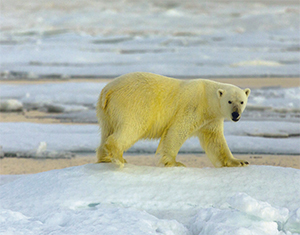
Sea ice is the hunting ground for polar bears, and during our adventures in Victoria Strait we saw several bears. On some occasions a bear was curious and came up to the boat to have a look at the creatures invading his territory. That was safe given that you keep some open water between the two.
 |
|
A curious polar bear on the ice in Victoria Strait. |
The concentration of ice got denser and more frequent as we moved south. The last band of roughly 8/10th multi-year ice extended for a half-mile and stopped Maia B. Our companion boats Salty and Snow Dragon stood by while we turned back to assist Maia B. It was the first time that we used Bagheera to extract another boat out of the ice and it was vital that we approached carefully so as not to damage their hull from the ice that Bagheera was breaking and pushing. We managed to maneuver in front of them and push a substantial block of sea ice out of the way. With Maia B now behind us, we continued through the ice, creating a new channel for them to exit and rejoin the others.
Past the ice
Once we reached Jenny Lind Island, the ice for the rest of the passage was behind us. We made more stops on the way and enjoyed the landscape. Wildlife was sparse, but beautiful. Wind was consistent and weak. When we were almost in the Amundsen Gulf, we got a weather forecast for strong headwinds. We stayed at an anchorage on the south shore while we waited for favorable winds. We still had 1,400 miles until Nome, Alaska, and practically no shelter in between — we decided to keep going.
In Nome, Erik’s crewmember suddenly had to fly home after learning that his house had been struck by lightning. It was mid-September and Erik did not have the luxury to wait and arrange for another crewmember before the winter storms. Instead, he single-handed the Bering Sea nonstop from Nome to Dutch Harbor, and then again to Kodiak with only a few stops along the way. From Kodiak to Sitka, Erik was rejoined by Krystina for the last crossing of the season.
It was early October and we departed Kodiak on the tail end of a low and made the 565-mile crossing to Sitka just as the next storm started pounding the Gulf of Alaska. It was the middle of the night, and though we could anchor off the house we bought in the spring, we have never been there by boat and there are a lot of navigational hazards. Instead, we anchored on a mudflat just off the town harbor.
Krystina Scheller co-skippers Snow Dragon II in the vessel’s home waters of Alaska. She has sailed extensively in the Arctic, including Svalbard, Greenland and Arctic Canada. Erik de Jong grew up sailing to the European waters of the far north. He designed the steel-hulled Bagheera, and built her from scratch with help from his father.

