The Maine Island Trail Association has launched a new app that lets boaters plan excursions and explore the coast from their smartphone.
The nonprofit group, also known as MITA, has updated the smartphone app for 2016. The app available from Apple iTunes and Google Play shows 217 sites on the nearly 375-mile Maine Island Trail and also shows landing areas and hiking guides for each location.
The new version features, anchorage locations, and launches and pump-outs along the coast, and other useful information. There are event listings highlighting local events along the coast and hundreds of photos.
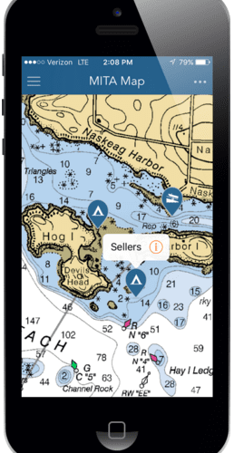
MITA’s app also features zoomable NOAA navigation charts of Maine’s coastline with trail sites and other useful resources embedded in the charts.
There is no charge to download the program onto iPhones, iPads and Android mobile devices, and boaters who are not MITA members can still view information for state-owned public islands. Current members will receive a code to view content for all locations along the trail.