At the end of the last century, Dick and Gail Barnes disengaged from the workforce and community volunteer life and began consulting while waiting for the commissioning of a new Nordhavn 50 trawler-style motor vessel. Dick was the President of a natural gas distribution company and a pipeline transmission company. When home in Anchorage, Gail remains active as a volunteer at the Alaska Native Medical Center.
Soon after moving from San Diego to Anchorage in 1966 they purchased an aluminum skiff; in 1971 they built a 19-foot rough-water river boat, and in 1991 bought a 28-foot Sea Sport cabin cruiser. The boats were used seasonally, fishing in Alaska’s rivers and somewhat protected waters of Prince William Sound and lower Cook Inlet. The Sea Sport was equipped with radar and a chart plotter which provided good night and fog navigation experience that was useful in transitioning to an ocean voyaging craft.
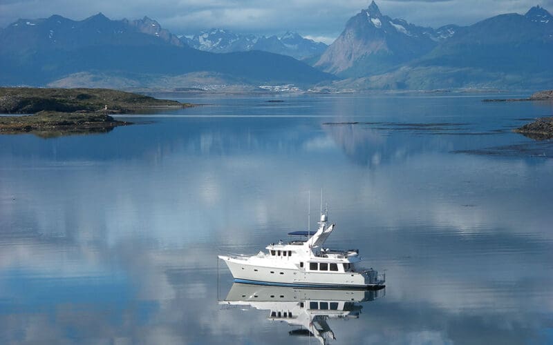
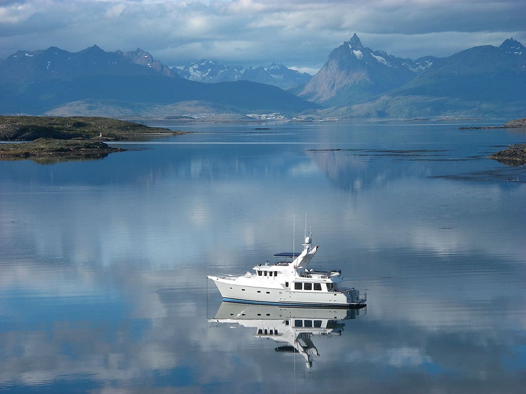
Ice Dancer, their Nordhavn 50, was delivered from Taiwan at the beginning of 2003. In 2005, they purchased Ice Dancer II, a pre-owned Nordhavn 57 with only 300 nautical miles on the hull, and sold the N50. Their ocean voyages total 114,564 GPS-recorded nautical miles, most in the Pacific Ocean bounded by the southern capes of Tasmania and Cape Horn, Marshall Islands, Attu at the west end of the Aleutian Islands and the west coasts of North and South America. Ice Dancer II is based in the Hawaiian Islands, almost equidistant and within fuel range of the Alaska, West Coast, South Pacific and Micronesia cruising grounds.
OV:
What are the top skills voyagers need to know?
D&GB:
Obtain a good understanding of your yacht’s mechanical and electronic systems and what routine and critical replacement parts and tools need to be carried on board for the intended voyage. Many destinations have scant supplies or marine support businesses.
Practice until comfortable with night-time navigation by radar. Optimal tuning of a radar requires practice. Similarly, night-time navigation and piloting skills using AIS and chart plotter equipment are important.

OV
What is your planning routine prior to a voyage?
D&GB:
Determine the optimal season and route to the destination and return, using historical pilot charts and publications. Navigating in bad weather or to weather is hard on yachts and crew.
Study the foreign government regulations and procedures for the intended ports of call. Having a scanner/printer on board is useful for providing document copies for port captains, customs and immigration officers.
If voyaging aboard a motor yacht, determine fuel availability, distance between sources, fuel burn rates and oil change timing to determine fuel and lubrication oil quantities needed on board. Carry along a complete inventory of fuel and oil filters, impellers and zinc anodes.
OV:
What is the most valuable skill you have picked up while voyaging?
D&GB:
I will list a few skills and procedures learned at sea that are valuable. First most, don’t fight head or beam sea conditions that are uncomfortable or dangerous. Bear off say 15 degrees, slow your pace and you will more likely enjoy your ride. Oftentimes the angle to seas will change within a half day and you can resume the best course to a destination or waypoint.
When dealing with beam seas using autopilot, navigate to a compass direction rather than to a waypoint. If tracking to a waypoint, a passing wave or swell will move your craft in the direction the sea is running and then, the autopilot will compensate by turning the boat closer to seas, potentially placing you in an unstable position. If the autopilot is set to a compass (or wind) direction, you will continue in the same direction, but be offset down swell. This can be compensated for by adjusting to a compass course slightly up swell to your intended course, but not over correcting.
We installed a commercial grade AIS system on our Nordhavn that displays similarly equipped ships on our chart plotter with real-time information of name, type, distance, speed, course, ship characteristics and time and distance to closest point of approach. Over the years, we have changed our speed or course dozens of times to avoid close encounters in the middle of the ocean. Having this equipment and experience using it is extremely important for safe crossings and even in situations of limited navigation like the inside passage of Alaska and dredged fairways and bar crossings.
Anchoring for the first time in a remote location can be dangerous, especially in countries that do not have updated charting or with limited vision at night. Both of our Nordhavns were equipped with commercial searchlight style underwater scanning sonar, designed for finding shoals of fish. It is like having underwater radar. Before dropping anchor, we set the sonar to 200 feet distance, about 20 feet of depth and scan a full 360 degrees around the boat. Any obstruction, even a pinnacle within that circle, will show up on screen and with an audible alarm. For anchoring at night, we have available 4,000 watts of high intensity floodlights that can literally light up an entire cove. We use the lights with some discretion, however, not wanting to ruin other boats’ ambiance.
Navigating in countries with poor charting is safer using the sonar system sweeping 120 degrees forward, 250 feet ahead and two degrees down angle. That shows any obstructions ahead both on screen and with an audible alarm. This proved immensely useful in Chile, Fiji and Australia, where we found antiquated charting and widespread rocks and coral reefs and heads.
We can carry 2,000 gallons of diesel in four tanks, two large and two smaller and draw from only one of the smaller tanks to a manifold supplying a main, auxiliary, and two generators. All the fuel in the engine chosen supply tank has been transferred through a two micron fuel filter and water separator. The fuel is filtered again en route from the supply tank to each user where it passes through a third, on-engine filter. This operational system has been successful with no clogged filters or fuel injectors.
OV:
Do you think the experience of voyaging has changed now that voyagers can stay more connected at sea?
D&GB:
Low orbit satellite internet and communication is a game changer for voyagers and a technology that will probably grow in importance. Weather information while at sea or in a foreign port continues to get better and contribute to safety at sea. The ability to get technical help, order parts and keep in touch with family has greatly improved.
OV:
Does the pressure to stay on a schedule sometimes contribute to you taking risks with bad weather?
D&GB:
Most of our voyages are crewed by the admiral and me, so, for us, there is little in the way of schedule pressure.
OV:
How do you handle provisioning? Do you have a system for determining the amount of food and water needed for a voyage?
D&GB:
We carry enough fresh food for ocean crossings plus plenty of canned and dry food for backup. While in distant ports, we take advantage of whatever local fresh food is available. We have a refrigerator/freezer plus two under counter freezers.
Our fresh water tank holds 285 gallons. We begin voyages with a full tank and our reverse osmosis water maker can replenish supplies at sea at a rate of 33 gallons per hour. We also carry a supply of bottled water for emergency use.
OV:
What do you find most challenging about ocean voyaging?
D&GB:
The most challenging aspect is late-night watches on longer voyages. Our schedule is three-hour watches from 9 pm to 6 am, local time. During the day we each take sleep breaks for as long as is needed to not be tired. Upon arrival, we do not feel overly tired and return to normal sleeping patterns.
Having a third person on watch limits the amount of late night duty. However, it introduces some additional complexity with schedules and return flights home for the third crew member.
OV:
Who or what inspired you to go voyaging?
D&GB:
Our boating has been a progression of bigger boats, but our working and child-rearing days dictated a schedule of short periods on the water and not extended voyages. The Admiral commented how it would be nice to visit other parts of Alaska, such Kodiak and Southeast Alaska. They were just the words a Captain loves to hear. At the time, I had been following adventures of others in cruising, voyaging and passage making publications, so when retirement time arrived, I was primed and ready.
OV:
What are your future voyaging plans?
D&GB:
Years ago, a good friend related that his father told him that many in their 60s are cruising, a few in their 70s, but hardly any in their 80s. We are staring at our 80s, but still have a few good voyages left. Our next run will likely be from Hawaii to revisit the Aleutian Islands, the South central and Southeast areas of Alaska, down the West Coast to Southern California, maybe a side trip to Puerto Vallarta, back to San Diego and return to Hawaii. We have enjoyed versions of this 6,000 to 9,000 nautical mile trip before.