Having made 20 or so trips up and down the Intracoastal Waterway (ICW) from Virginia to Florida I may be mistaken for an incorrigible ditch digger, but on almost every trip south I have combined offshore runs with ICW segments. Why you ask? Because it makes sense to utilize the best of both worlds.
My first trip south was on a tight schedule and I needed to get from North Carolina to Florida in a couple of weeks. It’s 1,090 or so statute (land) miles of Intracoastal Waterway from Norfolk to Miami. Averaging 50 miles per day, you’re looking at three straight weeks of motoring all day, every day. And that assumes you don’t have any mechanical breakdowns or get stuck behind a broken swing bridge that won’t open, and don’t spend much time ashore except for when you need to stop to purchase fuel.
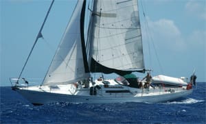
The ICW wasn’t looking like the best option for making it to Florida in two weeks, so I began popping in and out of the Waterway using safe inlets and running offshore when winds and weather were favorable. The first day of some of those offshore jaunts could be a bit rough, with 8- to 10-foot seas and big following winds, but the sailing was fantastic and we roared down the coast making excellent time going 24 hours a day.
That long-ago trip was when I first took advantage of using the Ditch and offshore runs together to speed up a passage south and to make for a safer and more enjoyable trip. There are many reasons to do the same.
Too deep and tall?
The first problem many voyagers encounter is that the ICW has height and depth restrictions that can be problematic for larger vessels. Between Norfolk and Miami, the theoretical overhead clearance set by numerous fixed bridges is a maximum of 65 feet, but anyone who needs more than 62 feet will find themselves slowed up during times of high tide. Onshore winds sometimes drive water into the waterway, limiting clearance at fixed bridges for days.
So you wait for low tide to clear the bridges, right? Unfortunately, a further complication for the bigger boats is that many areas in the Ditch have less than six feet of water at low tide, even though the official depths are supposed to be much greater. Numerous websites, guidebooks and online discussions are devoted to the latest reports of shoaling and how to deal with it. The bottom line is that anyone with a boat drawing more than six feet should plan on doing most of the route on the outside, or plan on digging your own ditch.
Straighten the curves
A casual glance at a chart of the East Coast will indicate the distance advantage to be found in taking shortcuts offshore from major inlet to major inlet. Headed south, the general trend of the coastline is an angle from the northeast to the southwest. From Cape Hatteras to northern Florida you will voyage approximately six degrees west in longitude, but the coastline is not a straight line. The northern part is formed mainly of large curves to the west, punctuated by points that reach out towards the Gulf Stream while leaving plenty of miles between the edge of the stream and shore.
The Gulf Stream is a major consideration when headed either north or south. It parallels the coast with its inner edge generally 60 miles or more offshore. With two knots or more of northeast-flowing current, a boat headed southwest to Florida needs to stay inside the stream, but a vessel headed out to Bermuda, the Caribbean islands, or the Bahamas will need to cross the stream at some point. This critical point often defines the basic route south.
The Bahamas are almost due south of Beaufort, N.C., but following the rhumb line would mean long days of fighting the Gulf Stream and the prevailing winds. The most practical route is to stay inshore of the Gulf Stream until Florida is reached, then head across to the islands. That route also shortens the offshore segments, lessens the time away from safe havens during hurricane season, and avoids long slogs to windward. Another practicality is that you will have the opportunity for a last-minute stock-up of fresh food, water, fuel and other stores, which are much more expensive in the Bahamas, if available at all.
The alternate route is to head southeast across the Gulf Stream at a right angle from some port north of Charleston; then, when out of the current, start angling back southwest. I prefer to leave from a point as close as possible to the stream in order to speed the crossing before the next front comes through. That makes Beaufort the most logical port of departure.
This often becomes a long, hard windward beat with the prevailing southeast to southwest winds, and even when east of the Gulf Stream one will be assaulted by the occasional strong cold front sweeping off the East Coast. I endured one of my worst offshore gales when on a course from Beaufort to the Virgin Islands in November. Despite being well past the Gulf Stream, we had Force 9-10 winds, 30-foot seas, and it was so cold that we were wearing ski hats and heavy fleece under our foul weather gear. It is easy to say that you will avoid these fronts by careful monitoring of the weather, but in the prime south-bound sailing season of November, fronts often arrive every three or four days, meaning you will get hit with one unless you are very lucky or very fast, or both.
Ports in a storm
Even if you have a very tall boat and/or a deep one, you can take advantage of several ports along the coast when utilizing the inside-the-Gulf Stream route. Many big boats make a run around Cape Hatteras to Beaufort and then keep heading south until the weather threatens before ducking back in. Deep inlets with no overhead clearance problems include Beaufort, Cape Fear, Winyah Bay, Charleston, Port Royal, Savannah/Wassaw Sound, St. Mary’s River and the St. John’s River. Headed south after that, the Florida coast has limited inlets and begins to trend to the east, nearly touching the Gulf Stream south of Palm Beach. Cape Canaveral is a good one to shoot for. Choose your weather wisely when running south down the coast, as it is mostly a nasty lee shore beach with a northeast gale.
Even if you are a dedicated offshore sailor, I highly recommend having onboard charts or a chartbook for some of these strategic ICW ports. Yes, they have well-marked and dredged inlet channels, but once inside you encounter numerous cross channels, poorly marked shoals, and the winding channel of the ICW. It can get confusing fast, with or without a chart. Keep in mind too that even if you are not blocked by low bridges, side channels are frequently crossed by power cables that may be within reach of your masthead. For boats that can negotiate the ICW comfortably, good mileage can be made heading south if the weather prevents you from sailing offshore. Numerous inlets allow you to pop back outside when conditions turn favorable.
 |
|
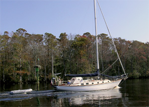
When the offshore option doesn’t work, duck inside and use the ditch. |
You won’t always find it easy to get to a marina, a fuel dock or even an anchorage in the Ditch with a deep and high boat. Again, guidebooks for the ICW will explain all. For example, though Winyah Bay entrance is deep and well marked, it is miles up-channel to Georgetown, which has a rather small and shallow harbor, and limited facilities for larger boats. The same goes for Port Royal Sound, unless you can clear 65-foot bridges and/or negotiate some of the ICW down to Hilton Head. Wassaw Sound south of the Savannah River is the approach to Thunderbolt where there are numerous big-boat facilities, but again it is many miles to get there and without ICW charts and guidebooks, you might need to call for help getting in. Savannah is a nice place to visit upriver and a big boat can get there, but marine facilities are limited to waterfront dockage — enjoy the town, but don’t expect to find repairs or supplies convenient.
Strategy
Since a trip south is likely to be made in November, the aforementioned cold fronts are a major factor. Some of these can pack a punch with winds up to gale force along with severe thunderstorms and very gusty conditions during the frontal passage. My preferred tactic is to wait in a safe port until the frontal passage has gone by to avoid both the thunderstorms and gusts, and to get a real-world sense of the intensity of the system. Weather reports are not specific to your harbor and local conditions may often be 50 percent different than the forecast. Sometimes just waiting for an hour or two after the frontal passage can help avoid sailing in 30- to 40-knot winds, and instead you will be romping south with a nice 20-knot northerly. Other times, the forecast 25 to 30 knots becomes 40 knots for several hours or even a day. In the fall, while waiting for weather in Beaufort, you will see boats limping in with shredded sails after a bad experience off of Cape Hatteras — don’t be one of them!
The second tactic is to go long and hard when the going is good and then sit for a few days until the next system comes through, or make your way south via the protected waters of the ICW. Use the in-between time to see the sights, get some rest, fuel up, etc. Frontal passages will be foretold by the wind gradually clocking to the west and then the northwest as the front gets close. Obviously, you want to get close to an inlet before it goes northwest or you will be trying to make port into the teeth of a gale. The good news is that you will be gradually moving toward shelter and not onto a lee shore if caught in these conditions. The deeper inlets are generally safe in bad weather, though smaller boats may want to avoid an approach when the tidal current is running into a strong wind, creating very rough seas at the entrances.
Hug the coast as close as you dare, thereby avoiding the Gulf Stream current; get some shelter from the coast and shoals with north winds and be in a good position to duck back inside before the next front hits. This often means making course from major sea buoy to sea buoy instead of taking a long straight shot from, say, Beaufort to the St. Mary’s River at the north border of Florida. It may add a few miles to the sailing, but often results in a faster, better passage. To ease the navigation chores, set your course angle in closer to shore during the day when you can see things then make sure the course angles well offshore at night, giving you extra sea room and less likelihood of having to deal with shoals, fishing boats or unlit markers.
Using this approach, you’ll find that your passage speed is often better than those who stay purely offshore enduring whatever weather comes along. Several times I have left Beaufort in the company of bigger boats, ducked back in when the weather turned bad, and then popped back out only to meet up again with the big boat in Palm Beach where they were getting sails repaired and fixing other damage from enduring a gale offshore. The straight line is not always the fastest route between two points.
John J. Kettlewell is the author of The Intracoastal Waterway Chartbook: Norfolk, Virginia to Miami, Florida.