Satellite observation of the atmosphere has been a powerful tool for meteorologists since the first weather satellite was placed into orbit in the late 1950s. The Geostationary Operational Environmental Satellite series (GOES) has been the backbone of operational meteorological satellites since the first in the series was launched in 1975. The most recent GOES satellite — designated GOES-R when it was launched in November of 2016 and now known as GOES-16 — represents a significant leap in data gathering and observational ability.
Early satellites provided only limited data compared to today’s coverage, but by the late 1960s and early 1970s, satellites had become more reliable. More regular observations allowing better tracking of weather systems became possible with the advent of geostationary satellites, which orbit the Earth at a speed equal to the Earth’s rotation, remaining over the same geographic location and at an altitude of more than 22,000 miles, allowing the observation of nearly an entire hemisphere at once.
GOES-16 (also known as GOES-East), began providing data in 2017, first in a testing mode, then transitioning to a fully operational mode in December. The improvement in the images sent back by the satellite is obvious, and the images are available online at the following website: www.star.nesdis.noaa.gov/GOES/index.php.
 |
|
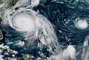
A GOES-16 GeoColor image shows hurricanes Lee and Maria, taken in Sept. 2017 while the spacecraft was being tested. |
The resolution of the images provided by GOES-East is much higher, which allows greater detail of smaller-scale weather phenomena to be observed. The imager also works much more quickly than the previous satellites, and this allows for a full hemispheric image every 15 minutes as opposed to every 30 minutes for the prior GOES-East satellite, and images of the U.S. are generated every five minutes. Animating (or looping) these images, which can be done on the website, gives much greater insight into the development of weather features. There is also the ability for the imager to zoom in on a smaller area of interest and gather images every minute. This allows better observation of rapidly developing weather systems, such as squall lines and tornadoes, and also improves the ability to observe tropical cyclones (tropical depressions, tropical storms and hurricanes) during periods of time when rapid changes are occurring.
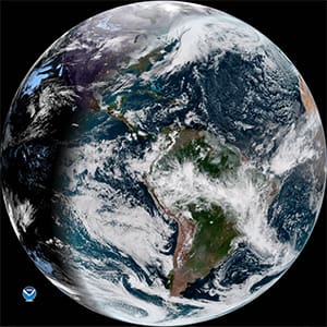
By going to the website referred to above, users can examine several different types of images and animations. On the front page of the website, you can see a hemispheric GeoColor image. This is a product that is designed to have the Earth look approximately as it would when viewed with human eyes from space during the daytime hours. At night, different sensors are used, which include infrared imagery to allow clouds to be observed based on their temperature.
By hovering over the different “View” menus along the top of the front page, in addition to the GeoColor option, there are 16 different “bands” that can be selected. These represent different wavelengths of energy that are emitted by the atmosphere and observed by the satellite. These bands have different uses, such as measuring the amount of water vapor at different levels in the atmosphere, determining the temperature of cloud tops and observing the presence of clouds at different levels. Collectively, using all the bands helps meteorologists to determine the state of the atmosphere. After clicking on a given band, a page with animation of that band will be brought up. At the bottom of each of these pages, a link is available that provides detailed information about the data included in each band and its most appropriate use.
 |
|
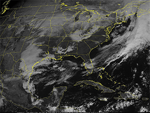
A Band 2 (Visible-Red) image of the continental U.S. taken about an hour and half after the full hemispheric image (shown above). |
For casual users, the bands of most interest are likely Band 2 (Visible-Red) and the GeoColor image. The Visible-Red band is best during the daytime as it represents visible light reflected from the Earth and captured by the satellite. It is essentially like having a regular black-and-white camera image. The resolution of this band is the finest at 0.5 km, meaning that great detail in the cloud features can be seen by zooming in on the images. This band does not provide useful information at night since it requires the availability of sunlight to reflect off the clouds to be observed. At night, infrared (IR) imagery is needed, which senses the temperature of the clouds (or other surfaces) being observed. There are many different IR bands available and information from several of these is amalgamated into the GeoColor image, so this makes a good nighttime image to rely on.
Going to the website and looking at the images is fun and informative, but for vessels offshore, limited Internet bandwidth may make this difficult. So how can ocean voyagers benefit from these great new pictures? The answer to this question gets to the most important aspect of this new satellite: the improvement of forecasts. Higher-resolution data and more frequent images will allow more accurate and timely forecasts to be issued. During the busy 2017 Atlantic hurricane season, GOES-16 data was used to help forecasters determine the strength and track of many of the devastating storms that impacted several regions and, accordingly, provide better warnings. The ability to observe hurricanes much more frequently than in the past will help to determine rapid changes in strength, which is one of the areas of hurricane forecasting that needs improvement. Also, the capability for more precise tracking of smaller-scale squall lines and thunderstorm areas will allow more lead time for warnings to boaters in near-shore waters. And over time, the collection of data will form a better database for researchers to increase our understanding of weather systems. So though it may not be possible to look at the pictures all the time, this new satellite will be benefitting all mariners for years to come.
The next GOES satellite (GOES-S) is scheduled for launch in March 2018 and will bring the same technology to the western U.S. and the central and eastern Pacific as it becomes GOES-17 and replaces the current GOES-West satellite.
Ken McKinley is a professional meteorologist and the owner of Locus Weather in Camden, Maine.