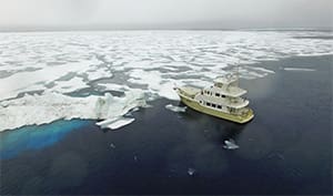
Migration’s stainless steel-clad stem came to rest gently against the polar ice pack, a mere 520 miles from the North Pole. To memorialize the moment, I photographed the GPS display’s latitude readout: 81° 27.7’ N. The crew shared a round of congratulations and posed for a photo on the bow, it being that much closer to the pole. While there were leads that would allow us to venture further north, the vessel’s master and crew agreed that we would go no further; we were confident we had set a record for the highest northern latitude achieved by a fiberglass power vessel, and would ask no more. With a fiberglass hull, regardless of its heft, we were tempting fate amid this much ice. Shortly after turning about and pointing our bow southward, however, our jubilation turned to dread as it became obvious that our plan was flawed: The path we took through the ice was no longer there. The leads, as they are wont to do, had closed.
The Svalbard archipelago is a land of extremes — extreme cold, extreme light and extreme darkness. During our month-long passage, the sun never set, while in mid-winter it never rises. The archipelago carries a host of “the northernmost” superlatives: continuously inhabited civilian settlement, post office, railroad, chain hotel (a Radisson with excellent Wi-Fi, thanks to an undersea fiber optic cable used to relay satellite data to the mainland; Svalbard boasts outstanding Internet connectivity), supermarket, phone booth, coal mine, etc.
 |
|
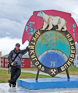
Steve D’Antonio in the once-booming Soviet mining colony of Barentsburg, now a ghost town. |
Svalbard, Norwegian for “cold coast,” is also known by its former Dutch name Spitzbergen (also an apt title, it means “sharp mountains”). The islands are located roughly midway between Norway and the North Pole and are well off the beaten path, particularly for cruising vessels and especially those of the power variety. Other than tourist charters, we encountered no others during our sojourn. Under special and seemingly peculiar treaties established in 1920 and 1925, Svalbard belongs to and is administered by Norway, although other countries are permitted to, and have, established settlements and commercial concerns here. No visa is needed to visit, and anyone can come here to work without the usual permits. Technically, while part of Norway, it’s not part of the European Union.
Built for high latitudes
Our vessel, the late model Nordhavn 68 Migration, is owned and operated by clients and longtime friends, a couple from Georgia. Experienced cruisers, they, along with their goldendoodle Gulliver, took delivery of the vessel in Florida in 2010 and then cruised to the Bahamas twice. Later they voyaged from Florida to Newfoundland (where I cruised with them in 2011), circumnavigating the island as a shakedown in preparation for a subsequent trans-Atlantic crossing. Their route included Newfoundland, Labrador, Greenland (where I also cruised with them in 2014), Iceland, the Faroe Islands, Scotland, Ireland, the U.K. and Portugal. Migration was built specifically for high-latitude and cold-weather cruising, and has served her owners well.
 |
|
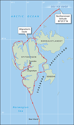
Passage began at Tromsø, Norway, then continued to Bear Island, the West Coast of Spitsbergen, north to the ice edge and then south along the East Coast. |
Our voyage north started at Tromsø in Norway. We slipped our lines at 2330 and moved into the Tromsø ship channel. Located well above the Arctic Circle on Norway’s far northern coast, Tromsø is a center for the Norwegian fishing fleet and the last resting place of the German battleship Tirpitz, sunk nearby by RAF bombers in 1944. We departed at that late hour in order to make a perceived but somewhat tenuous weather window; winds were forecast to be light, however wave heights at times could be significant — as much as 9 feet. The forecast thereafter only deteriorated and we opted to proceed, a decision we’d soon regret.
Migration was soon in the Langsundkjeften channel, an inshore passage between the mainland and outlying islands that leads to the Barents Sea. During the five-hour trek, fog alternately descended and lifted, while light rain sprinkled the windshield. Yet, in spite of the late hour, it remained bright — albeit in ethereal shades of gray.
Tough run to Bear Island
After 43 hours and 256 nm, we made landfall at Bjørnøya, or Bear Island. The passage qualified as one of the most miserable I’ve ever undertaken: 8- to 12-foot short-period waves on the bow and, contrary to the forecast, a steady 25 knots of wind. Although her bow periodically disappeared in a pearlescent explosion of seawater, Migration took it in stride. All systems performed well and there were no failures — her crew on the other hand was laid low for much of the journey. There was one saving grace: Because of our high latitude it never got dark, which meant while we could do little to avoid them, we could see and prepare for every oncoming wave.
 |
|
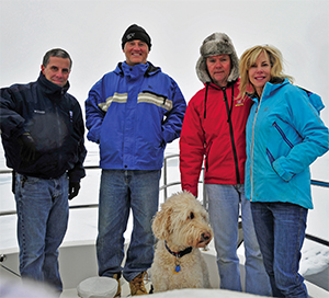
The crew of Migration celebrate their furthest north milestone. |
Upon our arrival at Bjørnøya we sought shelter in Sørhamna, located on the southeast tip of the island. It would be generous to call it a cove; it’s more an indentation in the lee of northerly winds. It was foggy and a cool 37° F, compared to 53°F when departing Tromsø. Shortly after we arrived, the fog intensified, making the shoreline — which was no more than 75 yards away — for the most part invisible. Still, determined to get some fresh air and stretch our weary limbs, Migration’s master and I launched the smaller of her two tenders and cruised the cove. We motored along cliffs festooned with nesting fulmars and puffins; the water around us was filled with bobbing birds. Most weren’t shy — some swam within a foot or two of Migration’s swim platform, a portent of things to come. We were careful, though, not to lose sight of the mothership for fear of not being able to find our way back — or worse, drifting out to sea.
We were afforded little time to lick our wounds, as we had a weather window that called for our departure in just a few hours. And so, with deep regret, we departed without going ashore. We took hot showers — never underestimate the restorative power of a steamy shower — ate for the first time in two days, and caught up on chores before weighing anchor and getting underway once again.
 |
|
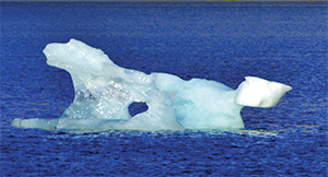
One of nature’s own ice sculptures. Due to numerous calving glaciers, floating ice is common around the Svalbard archipelago. |
Migration raised Sørkappøya, the southernmost tip of Svalbard, 24 hours and 174 nm after departing Bjørnøya. Mercifully, the conditions were far better than the first leg. Waves were just 4 to 5 feet with winds a scant 5 to 15 knots.
Neptune got the last word on this leg, however. The final few hours had winds up to 47 knots, the sea boiled and visibility dropped to a few hundred yards in mist and spume. Waves broke over Migration’s bow, the spray pelting the windscreen relentlessly, until we were at last in the lee of Svalbard’s Vesle Svartkuven peninsula. In spite of making the lee of the mainland and mountains, Migration encountered katabatic gusts in excess of 55 knots. Thankfully, the wind did offer some respite, blowing out the fog and cloud cover to reveal an azure sky and brilliant sunshine reflecting off snow-capped peaks and a trio of nearby coastal glaciers, which represent a small sampling of Svalbard’s 2,200 rivers of ice, including the world’s third largest.
 |
|
The lower section of a growler, an iridescent blue through the clear Arctic waters, exemplifies how much ice remains below the surface. |
Protection from the ice
After entering Hornsund fjord, the wind finally abated. We completed a slow cruise along the face of the Hansbukta glacier, at the end of which we opted for a diminutive anchorage called Kamavika. It was barely large enough to allow Migration adequate swinging room but it afforded us protection from both waves and a sea of growlers and bergy bits — plus SUV- and truck-sized chunks of ice — that were continuously cast off by the glacier. During the night we felt Migration rock periodically, the result of calving ice falling into the bay.
After two nights there, we departed Hornsund. The vistas grew more enchanting with each passing mile as Migration plied her way further north. Swirling mist enveloped moss-covered hillsides and an impossibly rugged and unforgiving coastline as sprawling glaciers, one after the other, filled our starboard-side bridge windows. Clutches of black guillemots and the occasional eider duck dotted the glassy calm surface as we slipped by. The air had a scrubbed crisp scent, a mixture of cold sea salt and pristine land far from the effects of civilization. The cycle of three or four days of heavy winds, rain and fog — the price to be paid for one or two days of magnificently clear weather and placid seas — would repeat over the next 25 days. Because they represented a minority, we came to savor the calm blue-sky days.
 |
|
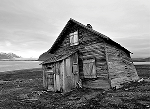
The cold, comparatively dry, low-bacteria environment preserves wooden structures. |
Migration’s circumnavigation of the archipelago included more than 20 anchorages, each one of which afforded her crew (numbering between three and five, as two flew in to join us after our arrival) unforgettable land and seascapes, and a wide range of wildlife encounters, including magnificent tusked walruses, whales, reindeer and tens of thousands of birds, all of which were migratory save for one, the Svalbard rock ptarmigan. And, of course, there was the archipelago’s star attraction: polar bears. If other regions of the world, places that are easily accessed, are likened to alloys — meaning they represent an amalgamation of civilization — Svalbard and locales of this ilk are elemental, the most basic, and the Earth’s few remaining wild places.
Named for a Bostonian
Though mostly deserted, Svalbard’s western shoreline does include grand fjords, towering snow-wreathed mountains and the few vestiges of population including the capital of Longyearbyen (named after a Boston, Mass., coal-mining magnate), along with a handful of scientific outposts, two active coal mines (one Russian and one Norwegian), two large abandoned mines and a handful of smaller mines, now defunct, nearly all of which we sampled. Most guidebooks consider this the “interesting” coast, and indeed it’s where most of the smaller Longyearbyen-based tour charter vessels travel.
 |
|
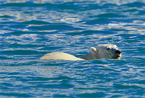
Polar bears are Svalbard’s apex predators and extreme caution must be used whenever going ashore to avoid and deter bear encounters. |
The eastern coastline is, in my opinion however, equally if not more enticing. While it lacks the picturesque fjords and high peaks of the western shore, it is truly deserted. There are no active settlements or scientific outposts; days go by without so much as a sighting of another vessel or even an AIS target. It is also virtually bereft of protected anchorages, which calls for careful cruise planning. We paid the price for experiencing this magnificent desolation once again, spending several nights in damnable open roadsteads, which induce incessant rolling.
In addition to our trek north to the polar ice pack, two of the voyage’s most unforgettable days unfolded as follows:
We were at Sallyhamna anchorage at 79° 48’ N latitude on Svalbard’s West Coast. Over lunch in the pilothouse, Migration’s crew took note of a sailing vessel a half-mile away; as it departed a nearby inlet, it abruptly altered course. We spied a white object in the water just ahead of it, and speculated it might be a beluga whale. We quickly realized, to our delight, that it was in fact a swimming polar bear traversing the mouth of the fjord. Two crewmembers and I jumped in the tender and headed out for a closer look. We chose what we considered a safe distance and one that we were certain would not stress the animal. As we neared this majestic beast, we gaped in wonder. He looked and swam much like a gargantuan snow-white Labrador retriever. We loitered several hundred yards away and watched as he reached shore. He casually looked back at us before majestically and nimbly climbing over the rock-strewn shoreline. He shook off, once again as a dog would, and then lumbered up to a nearby glacier where he rubbed his face in the snow. Then he rolled onto his back, sticking all four paws skyward, arching and scratching. He was roughly 8 feet long and, based on his generous belly, I guessed him to weigh 1,500 pounds. It was a truly awe-inspiring moment.
 |
|
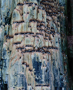
The bird cliffs of Alkefjellet are home to thousands of Brünnich’s guillemots. |
Sea bird cliffs
We detoured from our southbound route through the East Coast’s spectacular Hinlopen Strait to stop at a series of cliffs called Alkefjellet. These tower above the sea on the west side of the strait and are home to thousands of nesting Brünnich’s guillemots and a smaller contingent of kittiwakes. We maneuvered adjacent to the sun-splashed vertical face and loitered there for nearly two hours, taking in the mass of avian life. The sky and the sea, both on the surface and beneath as the guillemots dive and swim underwater, were so crowded with birds it was a wonder there weren’t regular collisions. Chicks could be seen and heard, their plaintive high-pitched cries a stark contrast from the adult bird’s raucous squawks. While most birds were busy feeding or tending young, some fought, occasionally to the death as evidenced by the handful of loser’s carcasses floating on the glassy surface. In a wildlife photographer’s life there are moments seared into his or her memory. I vividly recall each one of these, such as capturing images of Galapagos giant turtles, of Antarctica’s great wandering albatrosses and of Heligoland’s Atlantic gannets. To these I add Alkefjellet and the Brünnich’s guillemots.
Thinking back to when we were at the edge of the Arctic ice pack north of Svalbard, searching in vain for a southbound lead, I got the tiniest inkling of what Shackleton’s men aboard Endurance felt when beset in the Antarctic ice. There is a visual phenomenon of the sea ice called “ice blink.” It’s an iridescent white haze that hangs over the ice field. Ice blink is brighter where the pack ice is denser or where it completely covers the dark waters on which it floats. The absence of ice blink denotes open water. We used this feature, much like Shackleton and countless other polar seafarers have, to look for ice-free water. After what seemed an eternity but was, in fact, no more than 45 minutes of probing the pack, we at last found a promising lead parallel to but east of our route. With this exit strategy established, the tension level in the pilothouse dropped perceptibly. Looking back, like a ray of sunshine, the brilliant white line of the pack’s margin was visible in all its glory. With it in our wake, it is resplendent.
Steve D’Antonio is a writer, photographer and marine systems expert who after working for Zimmerman Marine, started his own consulting business in 2007.

