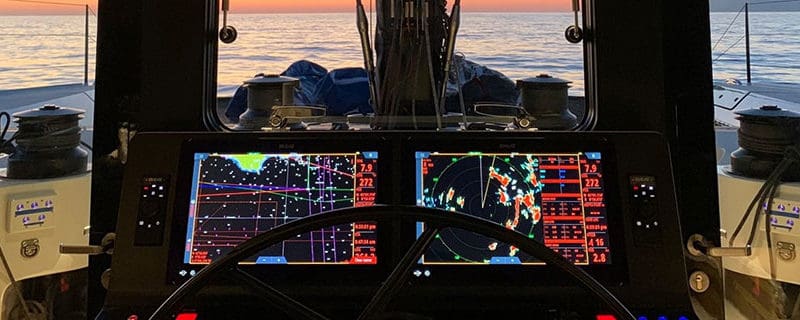
If you are planning an offshore cruise under sail, you need access to as much vessel data as possible in one single place. A multifunction chartplotter display is the nerve center of the modern offshore cruising vessel, bringing together chart navigation, radio communication and a variety of other inputs onto one screen to inform you of the overall performance of the craft while underway and at anchor.
Before committing yourself to a particular model of chartplotter, you need to consider several factors: vessel size, deck layout, planned location of monitor installation and of course, your own specific needs and tastes. Generally, a large monitor is located on a bulkhead in the nav station, but some boats offer plenty of room closer to the helm under a hard dodger, or even on a swivel mount at the helm itself.
On larger yachts, you have more options available from which to choose. You can opt for two complete systems, one above decks and the other below decks, both of them ensuring you have constant navigational control, no matter where you are on the vessel. And with the automatic operation and ease of use offered by the latest in navigation technology, keeping one nav station as a backup ensures navigation and communication capability in the event of system failure.
When sailing in inclement conditions offshore, it’s comforting to have a relatively quiet, well-lit place below decks where you can study charts and alter course periodically as needed. With a large monitor in the nav station, you can cross-reference with paper charts and jot down notes without seas crashing on your work.
And remember, regardless of how fancy your electronics, carrying paper charts to cover all cruising grounds is still a must. That may seem silly and old-fashioned to younger skippers, but there are still significant navigational advantages to paper charts. As you may have noticed, even a large-scale paper chart indicates shallows and obstructions not always visible in all elevations of electronic charts.
With reports of groundings on “uncharted” offshore shoals occasionally popping up in sailing news, we are reminded of the quality and authenticity of government-issued paper charts. It is almost certain those shoals appear on paper charts of the ocean areas in question. They may also appear on different elevations of the electronic charts.
All the same, this is a good, common-sense rule: while sailing offshore, use electronic charts to stay on track while referring to paper charts occasionally to have both a broad picture of your corner of the ocean and the security of being able to anticipate submerged shoals and rocks. When close to shore in familiar waters, use electronic charts but periodically refer to paper charts, just to be on the safe side.
Another ancillary navigation tool is a hand-held GPS or a small, binnacle-mounted chartplotter to keep you on course while either hand steering or making adjustments to the autopilot or windvane self-steering. Redundancy in navigation systems goes a long way toward ensuring a safe passage.
For the main array of GPS, charting and communication control, a wide assortment of packages and options is available to the aspiring cruising sailor. Large chartplotter displays all generally offer the same basic features, including a color monitor, a starter set of built-in charts and NMEA connectivity for a variety of inputs. Where they may differ is in monitor size, graphic resolution, quality of construction and to some degree, price. Expect your choice to offer connectivity to radar, sonar, AIS and autopilot. Other desirable features are WiFi connectivity and NMEA 2000 network capability.
Furuno TZtouch3
The Furuno TZtouch3 line of MFDs comes in four full-color screen sizes: nine-inch, 12-inch, 16-inch and 19-inch. TZtouch3 incorporates a quad-core processor for faster scrolling, panning, and zooming in/out. And the screens are touch-capable with edge-swipe features and single-tap menu options. And it’s possible to both plan and navigate in a 3D environment.
The TZtouch3 MFDs also have the Personal Bathymetric Generator (PBG) capability that allows you to create custom high-resolution shaded relief charts of the seafloor. Bottom images are drawn with shaded relief, depth contours, and variable colors. As for charts, the TZtouch3 units can access C-Map or CMOR or 3D Data or vector or raster charts or satellite photos with satellite fusion capability.
And it has a PIN code lock feature that keeps your data secure against theft. You can create routes at home using TZ Navigator, a web browser, or TZ iBoat iOS App. Then you can retrieve them from the cloud and download this and other data to your TZtouch3 MFD.
TZtouch3 incorporates a powerful internal 1kW TruEcho CHIRP depth sounder which can be upgraded to a Deep Impact (DI-FFAMP), a high-powered 2kW/3kW amplifier, or an even more powerful 5kW or 10kW transducer.
Raymarine Axiom Plus
Raymarine has recently released its Axiom Plus multifunction display, which is equipped with a powerful dual quad-core processor, enhanced data storage over previous units and upgraded Raymarine LightHouse Charts, along with Navionics and C-MAP.
The Axiom Plus’s 8.4-inch display offers access to charts, sonar, radar, weather and video in color that Raymarine claims is “twice the resolution of traditional displays.” Raymarine’s signature HydroTough nano-coated, impact-resistant glass screen repels water, oil and smudges for enhanced viewing and faster response through touch controls.
Also contributing to greater viewing capability are what Raymarine claims are wider viewing angles and sharper contrast than seen in other recent technology.
Simrad NSS9 evo3 S
One of the latest evolutions of Simrad’s line of multifunction displays is the NSS9 evo3 S, a unique name for a distinctive evolution in depth sounder technology. The NSS9 evo3 S takes off where its predecessor, the evo3, left off by splitting processing time in half and ensuring faster transitions and page loading.
The all-weather touch screen monitor with high-resolution color graphics can be viewed within an 80-degree angle in any direction. The “multi-touch” screen is protected by an “oleophobic coating” allowing for easy cleaning of fingerprints.
The sonar transponder, sold separately, includes DownScan and dual-beam viewing, multi-frequency operation and a sensor for water temperature. The transducer’s depth-measuring capacity exceeds 1,000 feet, a handy asset when fishing while underway. The latest “compressed high-intensity radiated pulse” (CHIRP) technology enables its highest range at mid to high settings, or 300 feet in down scan capability and 300 feet side scan.
Other features include NMEA data connection plus wireless connectivity, enabling monitoring via cellular device for remote viewing and navigation control. This model is rated waterproof IPXC6 and 7 and carries a two-year warranty.
Garmin GPSMAP 8610xsv
For those of us who were weaned on the early days of GPS and chartplotting with Garmin gear, the Garmin GPSMAP 8610xsv multifunction display is the latest evolution in a long line of navigation systems.
Offshore sailors and serious sport fishers alike will enjoy the Garmin 8610xsv’s 10-inch full HD PS touch screen monitor, which offers superior clarity and readability in sunlight, even with polarized sunglasses. And, like some of its competitors, multiple screens can be displayed individually for enhanced detail and viewing or edge-to-edge on the touch screen display for quick cross-referencing of data.
The GPSMAP 8610xsv comes preloaded with BlueChart g3 coastal and LakeVü HD maps featuring Navionics data. The system also offers Bluetooth connectivity, Wi-Fi networking and ANT technology, which is a proprietary, open-access, multicast wireless sensor network designed by Garmin subsidiary ANT Wireless. ANT technology enhances connectivity within the Garmin network, permitting faster digital switching, lighting and stabilization in the various systems linked to the monitor screen.
Pair up the GPSMAP 8610xs with a Garmin Panoptix LiveScope Scanning Sonar System transducer for viewing activity in real time up to 200 feet. Garmin’s Attitude Heading Reference System (AIRS) stabilizes sonar viewing on the chart plotter screen, even in rough conditions. Other optional peripherals may be connected to the monitor via NMEA 0183 and NMEA 2000 ports.
Lowrance HDS Live 12
If you demand a larger monitor screen, especially for bigger vessels where greater viewing distance is required, you will appreciate the centerpiece of the Lowrance HDS Live 12 multifunction display, which is a 12-inch horizontal monitor screen with 1280 x 800 resolution and full color.
Included in the HDS Live 12 package is an Active Imaging 3-in-1 transducer, along with CHIRP technology, which enables side scan and down scan capability up to 150 feet at 800kHz and up to 300 feet at 455kHz.
Pairing up with your cellular device enables the HDS Live 12 to display onscreen text messages and call notifications and offers full smartphone integration, permitting you to view video, Google Maps and data on your display. The HDS 12 offers a high-resolution SolarMAX HD screen, allowing you to view images from any angle, even in direct sunlight.
The HDS Live 12 package costs a few hundred dollars more up front than some of its competitors, but with the inclusion of the transducer, the overall cost of the multifunction display and transducer combo competes favorably with other products in its class.
B&G Zeus 12
The B&G Zeus 12 multifunction display with C-Map cartography is another high-quality chartplotter navigation system.
The Zeus 12 high-visibility SolarMAX HD display incorporates an all-weather multi-touch screen, which you can use even when it is wet. It is amazing how the fine sensors in the glass can tell the difference between saltwater and skin moisture, but this technology has become a mainstay among leading GPS manufacturers. Just for good measure, the Zeus 12 monitor also gives you the option of non-touch mode to ensure worry-free operation when the clouds unleash the worst of their fury.
Another key feature of the Zeus 12 is WiFi capability, which B&G provides through its GoFree Internet hotspot. Use your smartphone or tablet to view charts and control navigational functions from anywhere on the vessel.
B&G’s ForwardScan sonar and MARPA target tracking with AIS overlay give you a high degree of control, whether you are picking your way through shoals in the Tuamotus or racing around buoys in home waters. Zeus connects with a wide assortment of other sensors and instruments, including radar, sonar and remote GPS.
Choosing a chartplotter
When we are faced with the big question as to which chartplotter to choose for our offshore sailing palace, we must address a number of supporting questions, such as whether to purchase all the same brand of electronics as a kit, how and where to install the main nav system and backup, and ultimately, which company’s product line will ultimately provide us with the best overall service and quality.
First, for whichever GPS system you select, you should add an external antenna, if it is available, to ensure proper reception.
As for price, the range is not extremely wide, at most a few hundred bucks among units of the same size and capacity. Pick the unit best fitting your needs and tastes, and remember to always carry, at the very least, a handheld GPS as a backup, and if funds allow, a backup chartplotter system in case of main system loss due to lightning. Happy cruising! n
Circumnavigator-author Bill Morris is a frequent contributor to Ocean Navigator and the author of The Captain’s Guide to Alternative Energy Afloat (Seaworthy Publications, 2019).