I recently purchased a Samsung Galaxy Centura (an Android-powered smartphone) for my wife Thelma. They are truly amazing high technology devices, but what’s more amazing is the multitudinous apps that can be downloaded either free or for a nominal fee. I found one that cost only $9.99 from Google Play that has the potential to save one’s life.
Boat Beacon-AIS Marine Navigation is surely a must-have app for boaters who do not require AIS carriage (<300 tons) and do not want to spend the money for one, but would like AIS traffic information. Boat Beacon is available for both iPhone and iPad and for Android-based phones and tablets.
With this app you can receive real-time AIS ship information, over the horizon collision, SART and MoB detection from harbors, ports and coastal areas up to 15 miles out to sea. Such information includes bearing, range and closest point of approach (CPA) calculations. If a potential collision course is detected, an alarm goes off and bearing and distance information to the other boat is provided along with speed, course, location, name and length. This is all received on your smartphone/tablet with no VHF AIS receiver, transponder or antenna required. You will need GPS and an Internet connection.
You will be able to use the transmit option which transmits your boat’s position, speed and heading to global AIS systems (such as Marine Traffic, ShipFinder or AIS Hub) and other Boat Beacon users. Remember, however, that you will not be visible to other ships on their AIS systems unless they also use data from the same land based AIS networks. If you want to be seen on global AIS systems like Marine Traffic, ShipFinder or AIS Hub you will need to have and use an MMSI number. These numbers are free and can be obtained from the following websites: www.boatus.com/mmsi (the USCG approved agent) or in the U.K. visit ask.ofcom.org.uk/help/spectrum/mmsi.
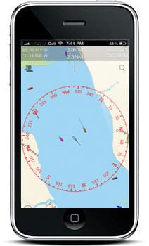
This app has a live map view with compass overlay that rotates with you so you can look in the direction of the ships on the map to locate them. You can share your boat’s track and position with friends and family instantly and in real time via e-mail, Twitter or Facebook. You can also be followed on AIS systems like ShipFinder or any others that have a free Web viewer. So much for the app itself, now we will give a few cautions about its use.
First: This app is only meant to be a help and should not be relied upon to determine precise locations, proximity, distance, or direction. In other words, IT IS NOT FOR NAVIGATION!
Second: Navigating a vessel is an exercise in multi-tasking and you must not let the Boat Beacon app distract you from your many other duties while conning your boat.
When I was flying small aircraft we were trained above all else to fly the plane, especially during an emergency.
In spite of all the tasks that need attending to during an emergency such as communicating the situation to the FAA, the primary task is to stay in control of the aircraft, since if you stall and crash nothing matters anyway. The same thing applies to staying in the control loop of your boat, so conn the boat and keep up your situational awareness. Don’t let an app distract you from staying in control.
Third is to keep your head on a swivel and continuously look around for other traffic, flotsam, etc.
These apps are a wonderful adjunct to our mariner tool kit and in closing I will mention just a few more that are very helpful for boaters and these are free from Google Play and include: TideApp, Boat Ramps, Boating Weather, Radar Now!, and Color Flashlight. There are similar apps available on the iPhone and iPhone as well. Next newsletter I will have some more helpful things that can be done with a smartphone, such as controlling equipment.

