Only a few decades ago your best chance for rescue at sea was an emergency broadcast on your HF SSB at 2182 kHz. If the propagation conditions weren’t right and/or no one picked up your transmission, you were likely out of luck. That changed with the introduction of the automated, satellite-based Cospas/Sarsat system in 1982. The system has seen steady improvement since then and now we are set for a leap forward with the latest iteration of satellite rescue called MEOSAR.
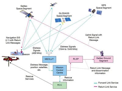
According to NOAA, the MEOSAR approach will provide: “near instantaneous global coverage with accurate independent location capability; provide robust beacon to satellite communication links, with high levels of satellite redundancy and availability; and the possible provision for additional (enhanced) SAR services, such as a ground to beacon return link.” A return link to EPIRB users would be particularly attractive to mariners in distress as it would inform them that their distress signal has been received.
The Cospas/Sarsat setup began with an agreement between the U.S., the Soviet Union, France and Canada in 1979 (the consortium has now grown to 42 participating nations). Cospas/Sarsat did not launch any satellites of its own, but instead used instrument packages that rode aboard Soviet and American global-orbiting weather satellites. These spacecraft orbited in 500-mile-high low Earth orbit (LEO). For weather satellites, this is valuable since it allows the satellite to pass over the entire Earth. The early system used 121.5 MHz as an operating frequency for distress messages. When an EPIRB switch was flipped, a passing Cospas/Sarsat-equipped satellite picked up the signal. The Doppler shift of the signal was used to determine the EPIRB’s position on the Earth (the low Earth orbit element is called LEOSAR by NOAA, which operates Cospas/Sarsat for the U.S.).
In many real world cases, the system worked well. There were drawbacks, however. The chief issue was poor specifications for the analog EPIRB 121.5 transmitters, resulting in sometimes off-frequency, low-power EPIRB signals that were difficult for the satellites to receive. A second issue was one of coverage. Since the satellites were fairly close to the Earth in LEO and the constellation was limited, the area the satellite could “see” was constrained and the gaps between satellite passes could be sizeable — not a good situation in a desperate emergency.
The first problem was tackled with the introduction of a new digital frequency, 406 MHz, and more rigorous specs for tighter “on-frequency” operation. The 406-MHz frequency was mandated and manufacturers quickly introduced 406-MHz units. As of February 2009, the Cospas/Sarsat system no longer used the 121.5-MHz frequency.
EPIRB position accuracy was further enhanced when GPS positions were encoded into the EPIRB transmit signal. With EPIRBs transmitting their position via GPS, there was no longer a need to rely solely on the less accurate Doppler shift locating method.
The at-times spotty coverage provided by polar-orbiting LEO satellites was enhanced by adding Cospas/Sarsat instrument packages to geostationary satellites (this element of the system is called GEOSAR). This added coverage reduced or eliminated coverage gaps (except for high polar areas).
The system as originally deployed and then with the various enhancements has been a huge part in saving lives of mariners, downed aviators and people lost or in distress on land. According to Cospas/Sarsat the system has saved more than 35,000 lives since 1982.
So far, LEOSAR/GEOSAR has been a tremendous boost to search and rescue capabilities. The next evolution of the system is to install Cospas/Sarsat instrument packages on medium Earth orbiting satellites (MEOSAR). And, much like the LEOSAR packages hitching a ride on polar-orbiting weather satellites, MEOSAR has a waiting ride into orbit: GPS, Russian GLONASS and European Galileo satellite navigation spacecraft.
One of the big advantages that MEOSAR will provide is near instantaneous EPIRB signal detection. There will be many more GPS, GLONASS and, eventually, Galileo satellites simultaneously in view to an EPIRB on the surface than is possible with the limited number of LEO polar-orbiting satellites with their restricted view of the surface due to their low orbits. Each of the three systems (GPS, GLONASS, Galileo) will have 24 active spacecraft, plus spares, in orbit. Thus, the chances are high that no matter where an EPIRB is located on Earth, there will be multiple satellites in position to pick up the 406-MHz distress signal. Since the satellites will be in approximately 10,000-mile-high orbits, they will also have a high probability of having an Earth station in view, allowing them to downlink the EPIRB signal. (In the MEOSAR approach, the instrument packages on board the spacecraft will operate as “bent pipes.” No processing will occur in space, EPIRB signals will simply be retransmitted back to the surface.)
And unlike geostationary satellites, which don’t change position relative to a stationary EPIRB on the surface that might have its signal blocked by an obstruction, MEOSAR satellites all move relative to the Earth’s surface, so a blocked signal could become visible from another angle.
Finally, with MEOSAR satellites, the possibility exists for a return link to the EPIRB from the satellite. Galileo satellites will reportedly be the first of the MEOSAR spacecraft to have this capability. After a user sets off his or her EPIRB, he or she will receive a return signal informing them that their distress message has been received by SAR forces and a rescue effort is being launched.
MEOSAR is currently in a demonstration and evaluation phase and is expected to have initial operational capability in 2016 and full operational capability by 2018.

