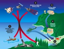
It’s an odd situation when high tech search and rescue technology can be foiled by something as simple as not filling out a form or a miskeyed registration number. Yet that unpleasant situation could occur should your emergency position indicating radio beacon (EPIRB) be improperly registered in the National Oceanic and Atmospheric Administration (NOAA) database. Evidently, this is not a freak occurrence as, according to some NOAA reports, up to 30 percent of EPIRB activations come from unregistered beacons.
The dangerous possibilities of mis-registration were made real recently when Lady Mary, a fishing vessel dragging for scallops off the New Jersey coast, sank early in the morning of March 24. Lady Mary‘s crew activated their 406-MHz EPIRB signal and it was picked up at 0540 by a geosynchronous NOAA GOES-12 weather satellite equipped with a Cospas-Sarsat transponder. The 406 EPIRB in question was built by the ACR company. “It was one of our beacons, called a Satellite 2,” said Chris Wahler, director of marketing for Cobham Life Support, ACR Products. “But it was not a GPS-equipped unit, so latitude and longitude data were not included in the signal.” Thus, the NOAA did not know which rescue coordination center (RCC) was the closest to the mariners in distress. What was included in the signal, however, was the beacon’s registration number, a vital clue that could help determine the operating area of the vessel in question. With the vessel’s registration number in hand, NOAA watchstanders can perform the simple task of calling the boat’s owner on the phone. This allows them to immediately determine if the EPIRB signal is a false alarm or if it is a serious emergency.
The EPIRB signal hit was ultimately relayed to the U.S. Coast Guard’s Portsmouth, Va., RCC. When the EPIRB’s registration number was checked, however, there was no vessel match. Even though the EPIRB had done its job, the Coast Guard couldn’t act on the alert. The RCC personnel didn’t know the identity of the boat or its location. There also was the possibility that the signal was a false alarm. The only course left open to them was to wait for the NOAA’s polar orbiting weather satellites to pick up the EPIRB signal. These satellites, which circle the earth every 90 minutes, have Cospas-Sarsat transponders onboard and can determine, via the Doppler shift of the EPIRB signal as the spacecraft passes over, the latitude and longitude of a broadcasting EPIRB.
At 0707, 87 minutes after the first EPIRB signal was received, RCC staffers finally got a fix on Lady Mary‘s EPIRB based on the polar satellite data. The EPIRB was off the New Jersey coast. A Coast Guard helicopter was immediately dispatched. When it arrived at the scene the helo’s crew discovered that only one crewman had survived the sinking. Six other crewmen, including the boat’s captain, drowned in the accident.
Later investigation by the Coast Guard revealed that Lady Mary‘s EPIRB registration number had been properly provided by Lady Mary to the NOAA. The number, however, had been miskeyed into the database by a private contractor hired by the NOAA to perform this function. The number manufactured into the beacon and the number in the database matched except for one digit. Had the number in the database been correct, the Coast Guard RCC would have known at 0540 the name and home port of Lady Mary and could have determined its likely operating area. The search could have commenced immediately, rather than nearly an hour and a half later.
Every EPIRB owner who registers his or her unit with the NOAA receives a sticker that must be placed on the EPIRB unit. This sticker is printed with the beacon’s registration number. EPIRB owners need to check the unit’s manufactured ID number against the number on the sticker provided by the NOAA. Wahler, of Cobham/ACR agrees, “What we’re saying to beacon owners is just double check. Make sure the ID the system has for you is the same as the ID number on your beacon.” If the numbers don’t match, that means your beacon is not properly registered. An incorrect registration (or no registration &mdash amazingly, up to 30 percent of emergency beacons are never registered by their owners) means added time that could elapse before SAR forces come to your rescue. To register your beacon, go to http://www.beaconregistration. noaa.gov/.
Another aspect of the fishing vessel sinking that has Coast Guard investigators scratching their heads is the lack of response to a reported VHF mayday call from Lady Mary. According to Lt. Tim Marriott of the Coast Guard’s Delaware Bay sector, the Coast Guard’s VHF network did not pick up a mayday call from the vessel. “We did not hear any call on our system,” Marriott said. “However, some vessels that were in the area did say they heard something.”
There were reportedly as many as 22 vessels in the immediate vicinity, including a merchant ship and another fishing trawler that passed Lady Mary within 1.5 miles. Yet, apparently, none of these vessels made an effort to respond or offer assistance to the vessel in distress.
You might think that the distress signal from a GPS-equipped emergency position indicating radio beacon (EPIRB), which provides a lat/long position to the National Oceanic and Atmospheric Administration (NOAA), would be all that is needed to perform a search and rescue operation. But that is not the case according to Lt. Shawn Maddock, Sarsat operations support officer at NOAA’s National Environmental Satellite, Data and Information Service (NESDIS) facility at Suitland, Md.
Maddock explained that although a GPS position-encoded signal is immensely helpful, the Sarsat system still uses the Doppler shift approach for finding a victim’s actual position. “Even if a signal is GPS encoded,” Moddock said, “we would do the Doppler shift method anyway. We always rely more on Doppler.”
A GPS-encoded EPIRB signal allows NESDIS operators to identify the general search area more quickly. It also allows them to use their polar orbiting satellite-based Doppler shift data more effectively.
As a satellite passes over a beacon, it uses the Doppler shift of the EPIRB’s signal to determine the beacon’s rough position. But because of ambiguities involved in this method, the satellite derives two possible positions, one to either side of the satellite’s ground track. At this point, however, NESDIS operators know enough to alert the rescue coordination centers (RCC) nearest to the two first pass positions. Sometimes one position is at sea and the other is on land. In that case, both Coast Guard and Air Force RCCs receive an alert on a possible search and rescue mission. To eliminate the two-position ambiguity, a second satellite pass is needed. The second pass also produces two positions to either side of its track. One of those positions, however, will coincide with one of the two positions obtained from the first satellite pass. The two positions that match will be the EPIRB’s actual position. If GPS data is available, that is used as an added cross-check.
Tim Queeney