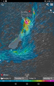
To the editor: We are currently in New Zealand aboard our Tayana 37 cutter Anna. We pay close attention to the weather and have observed some interesting patterns. Weekly frontal systems and their complex spin-offs occur here with uncanny regularity.
It is one of the elegant, albeit chaotic, algorithms found in nature, which in essence describes a recursive function embedded into our global weather patterns. It is a truly remarkable natural phenomenon, yet frustrating for a small sailboat trying to get from point A to point B at the wrong instant in time.
For anyone interested in the dynamics of global weather patterns, you can take a peek at windy.com and see how these patterns integrate as they morph and endlessly recur. We use Windy as one of our weather-planning tools when we have Internet access. Windy displays the grib (gridded binary file) output from both the ECMWF (European) and GFS (NOAA) computer-generated weather models. We have found both models quite useful — and increasingly more accurate — as long-range planning tools. We have found the European model somewhat more accurate in its output for short-range localized projections, possibly because it is a higher-resolution model and that helps with localizing weather. Nevertheless, we are talking about mathematical models that are tasked with trying to interpret and interpolate what is often unpredictable (nature’s extreme chaos) and that should be kept in mind when relying on mathematical models with 10-day projections of highly complex global weather systems.
If you look at a series of outputs from any of the global models (e.g., you download a grib file once every six hours) as a frontal system is approaching your area of the world, chances are that each instance in the series over the next 24 hours will look surprisingly different than the previous one. We would expect some difference between runs, but we also would expect some overall consistency in the model output in order to have any level of confidence in its projections. Models can let us see something forming or growing in intensity (like a cyclone) 1,000 ocean miles away, and models can project how that system will develop and where it might be, more or less, at a given point in time based on a combination of real-time surface and upper air flow data as well as historical analogues of data that resemble the current conditions. But these are still only projections; it’s highly educated guesswork when it comes to complicated weather system predictions. It’s still a broad brushstroke when it comes to pinpoint accuracy.
We’ve been out in conditions we never would have gone out in had that high-confidence forecast got it right. You learn pretty quickly that complex weather is still pretty much unpredictable. Very small variations in the paths of distant weather systems can result in inaccurate local forecasts. But thanks to mathematical computer modeling of global weather, we can now at least see a broad representation of what may be coming our way, which definitely helps us to plan a reasonable departure date when setting out on a passage, or determine which anchorage may be best suited for riding out a potential storm. When all the models agree (not something that occurs often), we have a higher level of confidence in what may be in store.
—Rich Ian-Frese, a retired research engineer, lives aboard Anna with his wife Cat. They are currently at New Zealand’s North Island and plan to venture to the South Island soon.

