Editor’s note: For this article, contributing editor Jeff Williams teamed up with Kiwi native and experienced passagemaker, John Martin. Martin has made the passage between New Zealand and the tropics over 35 times, “All of them great, except the first.”
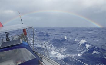
For the Coconut Milk Run voyager seeking a safe cyclone haven for the Austral summer, the passage to New Zealand is often viewed with equal parts longing and fear of big seas and bad weather.
It doesn’t have to be that way! In all of his trips, Martin only had one bad passage — his first. For Williams, there was one tough one too — the one with an imposed schedule.
Wisdom is just experience disguised and so here we attempt to pass along some of this hard-won knowledge without the gales of wind and boarding seas.
The big picture
New Zealand lies just west of the Dateline about 1,000 miles south of the tropical island nations of Tonga, Fiji, Vanuatu, and New Caledonia. Positioned far enough south to avoid most cyclones, New Zealand is — just as important for cruisers — far enough east to keep upwind in the trades for repeated trips to and from these idyllic cruising grounds.
 |
|
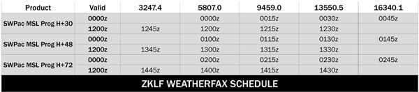
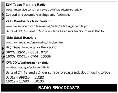
Schedules for receiving weather data from the New Zealand Met Service and the U.S. Coast Guard in Hawaii. |
Opua, near the North Island’s top end, is an excellent arrival and departure point for voyagers with New Zealand Customs and Immigration, a major marina and boatyard, two chandlers, and all services. The surrounding Bay of Islands is a superb cruising ground in its own right and voyagers can choose to begin their exploration of NZ from here or safely store a boat for extended travel home.
Most passages between NZ and the tropics are made on the cusp of cyclone season. Cruisers start leaving the tropics in late October and most have left by mid-December. Passages back to the tropics begin in mid-April and are generally finished by the end of May.
 |
|
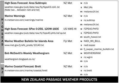
The key for the far right column is: w for Winlink, s for SailMail, and m for MailASail. |
New Zealand weather
Lying south of the normal tropical tradewinds belt, NZ weather is dominated by passing high and low-pressure systems in the mid-latitudes. High-pressure areas move west-to-east, separated by low-pressure systems, fronts, and troughs.
Wind circulates counter-clockwise around a high in the Southern Hemisphere, so as a new high invades from the west, southerly then southeasterly winds blow between NZ and the tropics. As the high passes the wind tends easterly. The back of the high brings northeasterly then northerly winds.
Between the exiting high and the next high-pressure area, a cold front likely extends into the tropics from a low-pressure system farther south. As the cold front approaches, the wind will tend northwesterly and is likely to increase in intensity. At the front itself, a sudden shift to the southwest announces the frontal passage as a “southerly change.” Blustery winds follow the front until the next high begins to assert itself with southerly and southeast winds.
On a (roughly) 1,000-mile passage between NZ and the tropics lasting six to 10 days, one is likely to see the passing of at least one cold front between adjacent highs. The secret to a pleasant trip is to time the route to take the best advantage of the moving weather systems while avoiding the worst wind or sea conditions.
Highs and lows are only the beginning; there are a lot of influences on weather conditions. Some excellent resources for a better understanding of New Zealand weather in particular are:
Mariners Met Pack, South West Pacific by Bob McDavitt, NZ Met Service.
The New Zealand Weather Book by Erick Brenstrum, Craig Potton Publishing.
Sailing to New Zealand and Weather for the Yachtsman by David Sapiane (download from www.pangolin.co.nz/node/59).
General passage guidelines
High-pressure systems migrate according to the seasons, tracking more northerly in the winter and southerly in the summer. Under the center of the high, there will be an area of little or no wind. Any passage to or from New Zealand is likely to encounter these conditions and fuel management will play a crucial role in departure/arrival timing. Plan on at least 48 hours of motoring.
 |
The top of a high reinforces the easterly tradewinds in the tropics. Generally, the higher the central pressure of the high, the stronger the trades will be as the high passes. Also with higher highs, the following trough or front is likely to have stronger winds associated with it. For passage planning, a forecast high of 1025 hPa (millibars) or less is preferred; anything over 1030 hPa needs to be watched carefully.
The cold fronts associated with passing lows tend to be much stronger south of 30° south latitude. Since most passages will encounter one front, it is best to meet these fronts at or slightly north of 30° south. In doing so, the frontal conditions are mitigated. On a passage to New Zealand, you minimize the remaining distance to run and increase your likelihood of arriving before the next cold front.
Tropical lows are to be avoided at all costs. If a closed isobar forms in the tropics or is forecast, beware! Cyclones can deepen quickly; storms can “bomb” under the right conditions. New Zealand may lie in the path of a re-curving cyclone as the storm leaves the tropics. (East Coasters, think “Bermuda” and “hurricane.”)
 |
Weather forecasts
Begin watching the sub-tropic region between NZ and the tropics several weeks before your intended passage. This will allow you to recognize the fundamental weather patterns — the speed, location, and intensity of highs and lows. You will also become familiar with the specific weather products you are likely to use during your passage.
The best overview of Southwest Pacific weather for sailors is Bob McDavitt’s weekly “Weathergram” issued most Sunday evenings (Saturday evening east of the Dateline). McDavitt discusses the major features likely to influence the weather in the coming week. He offers suggestions for timing passages between island areas and between the islands and New Zealand. Weathergrams are free and can be received by subscribing to an e-mail list-server at Pangolin or by downloading from Winlink or SailMail servers.
The best weatherfax products for this area are broadcast by ZKLF New Zealand twice daily beginning at 0000z and 1200z. Southwest Pacific weather charts for one, two, and three days into the future are followed by analyses for the Tasman and SW Pacific areas. Area weather charts for larger islands are broadcast from KVM70 Honolulu at 0701z and 1901z.
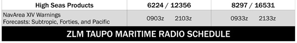
Text forecasts are available for download from the NZ Met Service and from the U.S. National Weather Service. These same forecasts are broadcast by ZLM Taupo Maritime Radio at 0903z, 0933z, 2103z, and 2133z and by NMO USCG Honolulu at 0005z, 0600z, 1200z, and 1800z, respectively.
———–
Jeff & Raine Williams circumnavigated and then some, ending up in New Zealand in 2010 with their J/40 Gryphon. Jeff is now involved in undersea research and exploration while Raine has been working with conservation groups in NZ focused on protecting native flora and fauna. Gryphon is nearby, waiting patiently.