With the recent loss of HMS Bounty in Hurricane Sandy, let’s revisit the story of another ship that was unable to survive the forces of nature.
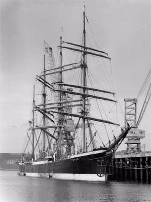
Similar to Peking, which we wrote of in our last issue, the barque Pamir was one of the famous P-Line ships built and operated by F. Laeisz of Hamburg, Germany. Pamir was the last of the Laeisz Line ships to round Cape Horn, in 1949. The four-masted barque was built at Blohm & Voss in Hamburg and was launched in July 1905. The steel vessel was 375 feet on deck, with a beam of 46 feet, and drawing 23.5 feet. Pamir carried 40,900 square feet of heavy canvas.
Like Peking, Pamir worked the nitrate trade, sailing regularly between Europe and the western Chilean port of Valparaiso. At the conclusion of World War I Pamir was handed over to Italy as a war prize. Laeisz bought the vessel back in 1924. Once again Pamir sailed to Chile around Cape Horn. The ship was again sold in 1931 and was used in the Australian wheat trade. During World War II Pamir was seized as a war prize by New Zealand. After the war it was purchased by a German industrialist and fitted out as a sail training, cargo vessel.
Pamir made regular passage to Argentina where she was used as a bulk grain carrier. On her last voyage, the regular captain, Hermann Eggers, was replaced by Johannes Diebitsch, who sailed on Pamir as a youngster and skippered sail training vessels, but who lacked experience as a master of cargo carrying ships. On Aug. 10, 1957, with 86 crewmembers, 52 of whom were cadets, Pamir departed Buenos Aires bound for Hamburg. The ship was carrying 3,780 tons of loose barley, but due to a dock strike the holds were filled by the untrained crew. Diebitsch erred in filling the ballast tank that ran the length of the ship with loose barley.
Even though Pamir was equipped with radio gear, it sailed right into the middle of Hurricane Carrie, with steady winds of 95 mph. In the midst of the hurricane with more than 150-mph gusts and 40-foot seas, the cargo shifted and Pamir began listing to port. The sails couldn’t be dropped fast enough and crew rushed around the vessel with knives slashing at the heavy canvas. Had the ballast tanks been empty Capt. Diebitsch could have flooded the starboard tank and possibly regained stability. Pamir had time to send distress signals at 13:03, Sept. 21. The vessel capsized and drifted keel up for 30 minutes, 600 nautical miles west southwest of the Azores. Only six crew, including two cadets, were rescued. As none of the officers and captain survived, the reason for the capsize remains unknown. The loss of Pamir was a national tragedy in Germany and it ended the days of cargo-carrying sail training.
Let’s join the captain on the quarterdeck somewhere in the South Atlantic when the weather was still balmy and beautiful, homeward bound, thinking of family and friends.
The day is Aug. 22 — we will use the 2012 Nautical Almanac. The DR of the vessel is 33° 25’ S by 30° 15’ W. We are doing a morning sun line and the time of the sight is 10:27:30 GMT. This is a lower limb sight of the sun and the Hs is 21° 33.8’. The height of eye is 35 feet and there is no index error.
A. What is the Ho?
B. Using H.O. 249, calculate intercept and plot.
C. What is the EP?
ANSWERS:
A. Ho is 21° 41.7’
B. Intercept is 15.3 nm away
C. EP is 33° 25’ S by 30° 15’ W or the same as the DR.
Extended solution
More practice in observation of the lower limb of the sun for finding an LOP of that celestial orb. The vessel is at a DR of 33° 25’ S by 30° 15’ W. Height of Eye is 35 feet. Time of sight 10:27:30 GMT. Hs of the sun is 21° 33.8’. We are using the 2102 Nautical Almanac.
GHA @10 hrs 329°18.1 Dec. N11°34.2’ (d)-.9
Min and sec 6°52.5’ – .4
GHA 336°10.6’ Dec. 11°33.8’.
-Ass Long 30°10.6
LHA 306°
Hs 21°33.8’
-dip 5.7’
App alt 21°28.1’
3rd cor + 13.6’
Ho 21°41.7’
HO 249 Vol 2 Contrary Declination to Latitude. Use Assumed Latitude S 33°
Hc 22°20’ d -41 Z 121° convert to Zn= 59°
S lat >180° ZN= 180°-Z
Table 5 -23’
Hc 21°57’
Ho 21°41.7’
Intercept 15.3nm Away
After plotting the Estimated Position is the same as the DR 33° 25’ S by 30° 15’ W