The National Oceanic and Atmospheric Administration (NOAA) has made great strides in improving hurricane and tropical storm forecasts. Supercomputers and satellites have changed the game and allowed for better accuracy in tracking and predicting the paths of these storms. But the technology and techniques continue to improve. This hurricane season, researchers at NOAA’s Office of Oceanic and Atmospheric Research have some new tools, ranging from an autonomous surface craft to drone aircraft, that will provide new data sets on hurricane formation and behavior. Improved hurricane prediction is obviously good news for ocean sailors.
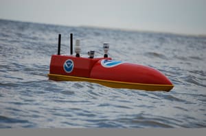
Voyagers with anything less than a 100-foot yacht might think their boat is too small to take on the fury of a hurricane. But NOAA’s new hurricane research device, an unmanned surface vehicle (USV) called EMILY, is just 5.4 feet long. And this diminutive craft is designed to plunge into the maelstrom of a tropical cyclone, head to the hurricane’s eye and gather data. It is equipped with a gasoline-fueled engine and can also use battery power for propulsion. EMILY can reportedly operate for 10 days before needing to refuel. The unit is internally divided by watertight bulkheads, said Justyna Nicinska, EMILY project manager. “It consists of four independently sealed bulkheads that contain the motor, electronics and navigation, fuel tank and forward sensors respectively.”
The unit’s low center of gravity helps with stability. “The payloads and internal components have been configured to provide a low center of gravity well below the deck and waterline,” Nicinska said. “The gasoline motor is fed through a series of air boxes that minimize the ingress of water and a pump continuously expels water that is collected internally through the air intake and exhaust. Additionally, the pipes for the air boxes are equipped with flow regulators that close when the platform is inverted.”
On board the EMILY unit is a suite of sensors that can record barometric pressure, air and sea surface temperatures, salinity, wind speed and wind direction. EMILY is also equipped with a high-definition camera that can relay images back to NOAA scientists. EMILY has an onboard satellite link that can relay data gathered from the eye of a storm.
Such surface level data from inside hurricanes has been difficult to attain, since most vessels, both commercial and recreational, do their level best to avoid hurricanes. And if they did get caught in one, most voyagers would likely have other things to do rather than record weather data.
EMILY was originally developed by Hydronalix Inc. for a variety of uses, including assisting lifeguards in choppy seas. NOAA researchers had the idea of modifying an EMILY unit for hurricane research. Hydronalix was able to develop the hurricane version using a Small Business Innovation Research grant with funding support from the NOAA Unmanned Aircraft Systems Program Office. The EMILY concept vessel was tested in the Channel Islands National Marine Sanctuary off the California coast.
Another new tool for studying hurricanes are drone (unmanned) aircraft. NOAA and NASA are collaborating in a program that uses Global Hawk drone aircraft to fly into storms. Two of these 44-foot-long, 25,000-pound unmanned aircraft are operating out of NASA’s Wallops Island, Va., base as part of NASA’s Hurricane and Severe Storm Sentinel (HS3) program. These are large aircraft, with a 115-foot wingspan and they can fly at nearly 65,000 feet for up to 28 hours while gathering hurricane data. The Global Hawk drones participating in the HS3 program will carry a variety of instruments based on the type of data researchers wish to gather. Instruments that will be mounted on the Global Hawk aircraft to examine the environment of the storms include the Scanning High-resolution Interferometer Sounder (S-HIS), the Advanced Vertical Atmospheric Profiling System (AVAPS) also known as dropsondes, and the Cloud Physics Lidar (CPL) (Lidar is an acronym for light detection and ranging). Another set of instruments will fly on the Global Hawk when researchers are focusing on the inner region of the storms. Those instruments include the High-Altitude Imaging Wind and Rain Airborne Profiler (HIWRAP) conically scanning Doppler radar, the Hurricane Imaging Radiometer (HIRad) multi-frequency interferometric radiometer, and the High-Altitude Monolithic Microwave Integrated Circuit Sounding Radiometer (HAMSR) microwave sounder. Most of these instruments represent advanced technology developed by NASA that in some cases are precursors to future satellite sensors.
A major part of the Global Hawk drone’s efforts will be to deploy up to 500 dropsondes. These are sensors that the drone drops at preset times. They radio back data and provide a vertical profile of the storm.
Both the EMILY surface unit and the Global Hawk drone should provide substantial useful data and help answer one of the prime questions that scientists have about hurricanes: Why do some storms gather speed and intensity and others do not? Knowing the answer to this question could help improve current hurricane computer models and develop the next generation of models.
In addition to the EMILY and Global Hawk drone tools, NOAA has a few other new tools to also improve storm prediction. One of these is an improved sensor on board NOAA’s NPP polar-orbiting satellite. In order for meteorologists to initiate computer model runs and to start to make forecasts about a storm system, they first have to locate the center of the system. This can be a challenge even during daylight. At night, this task becomes even more challenging. Now NOAA scientists are testing a new sensor called the day-night band sensor. This device is so sensitive, it can see in the dark using reflected moonlight. This allows the centers of storm systems to be identified and the process of running computer models and making forecasts can begin, instead of having to wait until daylight.
Other developments include smaller drift buoys that can be dropped from a wider variety of aircraft, not just the large C-130J hurricane hunters; improved techniques for merging satellite and aircraft observations to generate highly accurate maps of surface winds at 10-meter resolution; and a new software approach to forecast the seasonal hurricane frequency in the North Atlantic.
With these and other develop-ments mariners should have better hurricane forecasts that will enable them to avoid these storms and be ready when one does come ashore.