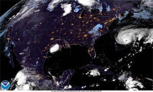
The 2019 Atlantic hurricane season has been rather active so far, and the historic peak of the season, which is Sept. 10, is two weeks in the rearview mirror at the time of this newsletter. We have seen Dorian produce unimaginable destruction and significant fatalities in the northern Bahamas, as well as significant impacts along the Carolina coast of the U.S. And, at the time of this writing, Humberto is bearing down on Bermuda with hurricane conditions imminent there.
Prior to reaching Bermuda, though, Humberto passed nearly right over a NOAA weather buoy, and this provided an excellent opportunity to examine the impact of the hurricane. So, this newsletter will be rather short on words and will allow the data to speak for itself.
 |
|
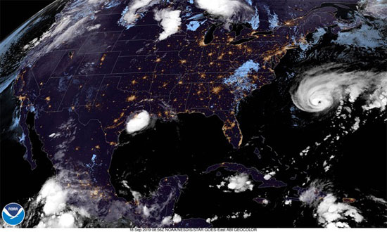
Fig. 1: GOES-16 geo-color satellite image from 0856 UTC on Sept. 18, 2019. |
NOAA buoy 41048 is located in the Atlantic about 240 nautical miles west of Bermuda. At about 0930 UTC on Sept. 18, 2019, the eye of Hurricane Humberto passed almost right over the buoy. Figure 1 is a geo-color satellite image from 0856 UTC on Sept. 18, 2019, and the eye of Humberto is quite obvious.
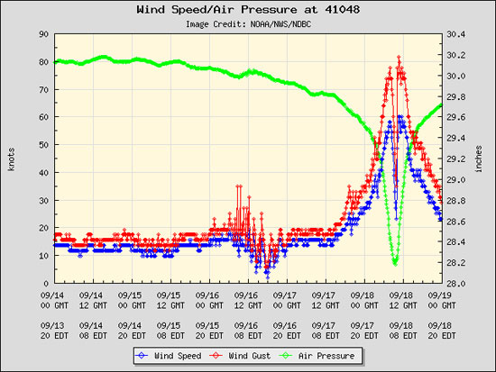
Figure 2 shows a combined plot of sustained winds, wind gusts and pressure from the buoy. The green data points show the pressure and illustrate very clearly the sharp drop in pressure as the hurricane approaches the buoy, followed by the sharp rise as it departs. The minimum pressure recorded by the buoy was 28.18 inches of mercury, which is equivalent to 954.2 millibars. The rapid change in pressure indicates a very tight pressure gradient (lots of isobars over a short distance) and this will produce stronger winds. Therefore, it is no surprise that the wind speed plots increase dramatically during the periods of rapid pressure change. The maximum sustained wind speed measured by the buoy was 60.2 knots, and the highest wind gust recorded was 81.6 knots, both occurring about an hour after the eye went over the buoy. Similar wind speeds were recorded in the hour or so before the eye reached the buoy.
 |
|
Fig. 2: Data plot of sustained winds, wind gusts and surface pressure from NOAA buoy 41048 from Sept. 14 through Sept. 19, 2019. |
As impressive as the strong wind speeds and the pressure plot are, notice the remarkable drop-off in wind speed as the eye passes over the buoy. The sustained winds dropped to just a bit above 20 knots.
A couple of final comments on Figure 2: First, it is quite possible that the wind instrumentation may not able to measure stronger winds and gusts as accurately as lighter winds. The accuracy parameters are 10 percent of the measured wind speed, so it is quite possible that the winds were even stronger than the data shows. But the trends are accurate, and that is most of the story. Second, it is likely that the eye of the system did not pass exactly over the buoy, but it was very close. If the eye had gone right over the buoy, the wind speed may have dropped off even more than the data showed.
 |
|
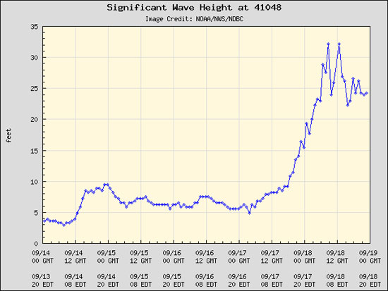
Fig. 3: Data plot of significant wave height from NOAA buoy 41048 from Sept. 14 through Sept. 19, 2019. |
Figure 3 shows the sea state, measured by the buoy as significant wave height. This is defined as the average of the highest one-third of all the waves present, and the software on the buoy is able to calculate this from the rising and falling of the water. The wave heights at the buoy peaked at 32 feet with just a slight dip as the eye passed. It is important to note that the wave heights began to increase earlier than the wind speed, which shows that the large waves of the hurricane will arrive before the strong winds. Also, the waves stayed high even after the wind began to drop off.
 |
|
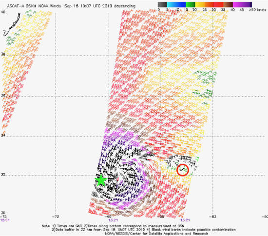
Fig. 4: Data plot from ASCAT satellite radar scatterometer from 1321 UTC on Sept. 19, 2019. |
A final piece of data comes from the ASCAT satellite, which is able to sense the ocean roughness with a satellite-mounted radar instrument and translate this data into wind speed and direction. Figure 4 shows ASCAT data from a satellite pass at 1321 UTC on Sept. 18, 2019, or about four hours after the eye had moved over the buoy. The green star shows the approximate location of buoy 41048, and the red circle shows the location of Bermuda. The circulation around Humberto is quite obvious.
The data sources that are now available (buoys, advanced satellite observations and state-of-the-art scientific aircraft) allow us to learn more and more about these powerful weather systems, and continue to yield better and better forecasts.

