The navigation station in today’s offshore sailing vessel is bound to be equipped with a chartplotter linked to GPS, AIS, a radar, a depth sounder and other inputs. But what about those little shore adventures in the dinghy, or hikes among hills through thick foliage on a tropical island leading perhaps miles away from your main vessel? This is where a hand-held GPS unit with a chartplotter can be a powerful navigation tool, enabling you to more fully enjoy your cruising career.
The market for hand-held marine GPS 20 years ago attracted a variety of manufacturers, including Magellan and Standard, to compete for our business. As a nod to Magellan, its current selection of land-based GPS handhelds is impressive, featuring detailed maps with trails and offshore roads for the ardent hiker, mountaineer and cyclist. But the field today for hand-held GPS coupled with ocean chartplotting has narrowed to one company known for producing highly dependable marine electronics: Garmin.
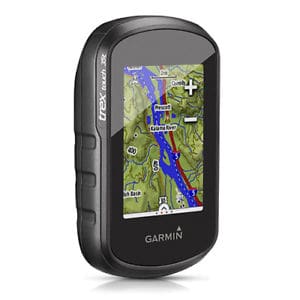
One hand-held GPS popular with cruisers is the Garmin eTrex Touch 35 hand-held GPS with world basemap. A unique feature of the eTrex Touch 35 is its access to Russian GLONASS satellites in addition to standard GPS satellites. GLONASS contacts permit faster lock-on speeds while the GPS unit receives added precision from standard GPS contacts.
The eTrex Touch 35 offers a “built-in, three-axis, tilt-compensated electronic compass” allowing you to follow a trail while leaning on a bicycle or bouncing over swells in your dinghy while staying faithfully on course. Beyond the worldwide basemap cartography, you can add charts to the unit through either the USB or microSD port.
With sensors for heart rate, ambient temperature, bike speed and bike cadence, plus a battery life of up to 16 hours, the eTrex Touch 35 is a great tool for cruisers who require a go-anywhere, multifunction navigation tool priced at less than $400.
The eTrex Touch 35t is virtually identical to the Touch 35 with the added benefit of 100,000 U.S. topographical maps for those cruisers who also have a penchant for hiking and mountain climbing. The Touch 35t also features 8GB of additional memory allowing you to upload more charts.
Garmin’s eTrex Touch 25 offers most of the features of the 35 and 35t but for roughly $100 less. You will find the same USB and microSD ports for uploading charts, plus the same fast access to both GPS and GLONASS satellites for fast, accurate GPS positions anywhere at sea or on land. The only thing you give up for that difference of 100 bucks is the sensors for heart rate, ambient temperature, bike speed and cadence (dinghy dance?), which the average cruiser probably doesn’t need anyhow.
All three of these Garmin hand-held GPS units — the eTrex Touch 35, Touch 35t and Touch 25 — come with 250,000 preloaded geocaches from Geocaching.com. For those who are scratching their heads at this last item, geocaches are spots around the world where there are hidden containers, sometimes zip-lock bags or Tupperware bowls, containing small gifts or trinkets to be traded anonymously with individuals who locate the hidden containers. How this could enrich your oceanic life is beyond me, but hey, you may find this tantalizing.
Find the hand-held GPS chartplotter best fitted to your needs, and add one more fun way to enjoy your cruising life!
Circumnavigator-author Bill Morris is the author of Sun, Wind, & Water: The Essential Guide to the Energy-Efficient Cruising Boat and is a frequent contributor to Ocean Navigator.