In the middle of June, a 60-mile-wide belt of ice still stretched from the Strait of Belle Isle northward, as it does every early summer in the western Labrador Sea. Frances B, our Mason 44, had meandered her way through scattered icebergs piled against the coast of Labrador. Out in the open seas, light variable airs wafted the boat over prominent long swells from the southeast. The nights grew shorter as we climbed up the latitude ladder on the 750-mile-long passage from St. Lewis Sound to the mid-coast of western Greenland. Now, only rarely did the radar bring a flash of a target — surely a distant iceberg, since few ships pass this way.
On the third day out, a grib file from Saildocs via our SSB radio brought a hint of imminent excitement. The isobars formed a huge hourglass with well-defined lows imbedded at the top and bottom of the system. Soon a good southerly breeze let me boom out the genoa for a wing-and-wing run and Frances B took off. By the next afternoon, punched by a muscular southeasterly wind, our usually stable boat was doing its best imitation of a Volvo racer: decks awash in heavy water, the main boom dragging through the sea, the crew soaked like drowned cats. At 50 miles from the west coast of Greenland, the air — heavy with fog and spume — was also bone-cracking cold. We couldn’t see more than a few waves away, but the radar picked up targets. Stationary, they had to be iceberg stragglers drifting north from the southern tip of Greenland.
 |
|
A dismally dark morning as Frances B runs wing-and-wing toward Greenland. |
The wind reached the booming whine that comes at more than 40 knots. Anxiety mounted. I crawled to the mast to crank down the ultimate defense: the fourth reef in the mainsail. It helped for a while until the seas became even more aggressive. We finally hove-to under this little scrap of sail, and the world instantly calmed down. Now that we had become more spectators than cannonballs, the Davis Strait seas looked beautiful — rows of rolling hillocks with their tops, when not breaking, shining translucent green against a lowering steel-blue sky.
Wind with a vengeance As the southern part of the system went through, the wind eased. We were sailing again happily, though quite unsteadily, over the remaining seas when the wind came back with a vengeance. But now, boosted by a momentary glimpse of high black land wearing a white cap, we pressed on excitedly, sliding down great long waves.
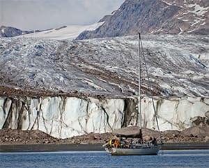
 |
|
Returning to the boat after a hike at Agpat anchorage. |
A few hours later, islands of bare stone and a lighthouse flew by. Gradually waves turned to mere sea wrinkles. The entrance into Færinghavn, narrow and rock bound, led us to the inner harbor. With my wife Nancy on the bow, I swung this and that way, looking for reasonably shallow anchorage, when she yelled, “Rock, rock!” Our heavy boat doesn’t stop instantly, even with full reverse, so with a bang the bow rode up, aiming for the sky, then slipped backward to free ourselves. Chastised, I decided that 50 feet would be a fine depth for our 400-foot chain and we finally swung at anchor. Snow streaked the ancient-looking land of rounded hills to windward. Now and then, gusts slid down to rough up the anchorage, flocks of large gulls stood sentry on the cliffs and a raft of ducks hove-to in the lee nearby. We slid the hatch shut, fired the heater and began thawing out.
The sky had cleared into pure blue when the wind began to turn against us on the way to Nuuk, Greenland’s capital. To starboard, the land grew higher — the beginning of the fjords that lead inland for a good 50 nautical miles, well past the city. In port, ships and boats of all sizes crowded the wharves; rafting alongside local boats is the only way to moor here. We chose Auvek, an ex-walrus hunter built of oak in Denmark almost a century ago and now, with its harpoon gun still on the foredeck, used as a pleasure craft. Nuuk began its existence as a port when the Danish pastor Hans Egede arrived in 1721 on his sadly successful campaign of destroying the native culture. From a prominent hill, his statue dominates the bay near the old town — a bit of the 19th century in this modern city of 16,000 Kalaallit (Greenland Inuit) and Danes. A small cultural museum nearby tracks Greenland’s human history with outstanding exhibits from Greenlanders’ lives.
 . . |
|
Homes in the town of Aasiaat overlook the southern shores of Disko Bay. |
Kayak skills preserved
Outside I wandered past cauldrons once used for melting blubber for oil, and I stumbled onto a rack of kayaks of strictly Inuit design. Now made of plastic, they belonged to a boat rental business. I had thought we could only see them in the Kunstmuseum in Nuuk, depicted in paintings by a few long-gone Danish artists. Later we would witness how several kayaking clubs preserve the skills of kayak handling. In the most remote northern villages, men are still harpooning seals, walrus, narwhals or belugas from kayaks.
Nuuk has all the advantages of a large city: modern groceries with European goods, machine and electrical shops, marine electronic repairs, a large boatyard and air connections to Europe via Iceland and Denmark. The weather there is infamously wet and windy. We soon escaped, heading toward the Arctic Circle at 66° 33’ N.
 |
|
Frances B’s route during the Greenland voyage. |
Thick fog and a light southerly changed to a brisk northerly a few hours after passing the circle, where we did the Arctic Circle dance and issued certificates to Ash Buchanan and Nick Brenner for sailing with us. Conveniently, the suddenly clearing air revealed mountainous shores as well as low islands at the approach to Sisimiut, Greenland’s second largest town (home to about 5,000 inhabitants), which sits on a protected harbor basin. A shoal in its middle forces all vessels toward the harbor edges already crowded with local craft. Rafting alongside is accepted and we promptly grappled Sisak IV, a good-size rescue vessel moored right on the deep inner side of the breakwater.
A maze of islets
A maze of thousands of islets and islands flank Greenland’s western coastline, from Prince Christian Sound in the south all the way to Disko Bay. Between them run sparsely marked passages sheltered from ice and ocean swells. With our 7-foot draft, we knew we would have to scamper inside with caution. Ten hours after Sisimiut, bound for Aasiaat Harbor on the south side of Disko Bay, we headed in through curtains of damp whiteness that gradually thinned inland. The midnight sun wanly sketched the way ahead, a very welcome aid since the radar wouldn’t be able to tell the difference between ramparts of rock and equally invincible monuments of ice trapped in the narrow channels.
 |
|
Crewmember Nick Brenner cools off in Disko Bay by doing his signature backflip near a giant iceberg. |
We powered on, often passing towering icebergs anchored to the bottom hundreds of feet below. Typically some 90 percent of a berg’s total volume lies under the surface. In those 80 miles of sheltered waters, we had the choice of anchoring off wild islands or a village. The Danes bring bright colors to Greenland; in Kangatsiak, with its population of 600, small wooden homes of bright red, green, blue or yellow spread like a quilt over a background of rock walls and boulders.
Say “Disko Bay” and most inveterate world tourists think “icebergs.” Two major glaciers spill mounds of ice the size of New York City blocks from the Greenland ice cap into the southeast end of the bay. This ice drifts out toward Baffin Bay, transformed in shape and size into a stupendous sort of art created by Earth itself. From Aasiaat, we planned to sail north and eventually to Vaigat, a narrow strait between northwest Disko Island and the mainland. The first anchorage at Grønne Islands, 25 miles northeast from Aasiaat, resounded with the shrill calls of thousands of Arctic terns breeding there. On the far horizon, between the low islets, loomed what looked like a distant continent of white cities. As Frances B moved north, this parade of icebergs firmed and thickened. We changed course to northeast, hoping to bypass this ice barrier and visit mainland anchorages farther north that — on the chart, at least — promised anchorages in dramatic scenery.
 |
|
Fellow crewmember Ash Buchanan joins Nick. |
A funnel of ice
Gradually, brash ice around icebergs thickened into a gruel of crumbled ice cakes and chunks of shattered bergs. The leads of open blue water narrowed. Were we heading into a tightening funnel of ice? Relaxed by calm water and everlasting daylight, I carried on until both the radar and my eyes showed a solid line of hummocky ice ahead and to port. Forget steering west to get free — or northward, for that matter. We pointed the bow east into Langebucht, a long cleft in the mainland, hoping to find an ice-free place to anchor.
A couple of hours after midnight, the sunlight intensified into a painful glare that hid growlers in the glittering sea. The headwind rose to 20 knots, spitting a river of thick ice from the fjord ahead. At 5 a.m., after hours of dancing with the ice, we had to turn back. Around 7 a.m., we shot westward between bergs afloat in looser ice floes and went for the Disko Island shore. But there was no clear passage northward there either; the escape route led southward.
The two of us were taking one-hour watches of unwavering concentration. After 40 hours of this, we were ready for real sleep. Fortune Bay on the south shore of Disko Island looked promising, and only large scattered bergs loomed ahead. The approach to the bay called for vigilance. Good visibility held, but small, grounded bergs confused the radar picture. I plotted a GPS fix on our paper chart (the last survey having been taken in 1976) and it didn’t agree with the digital version. A conspicuous cairn on the hill to port marked the channel, I hoped. Then it moved and changed into a large husky dog. The best clue came from the charted mid-channel rock awash that popped into view. We slipped into a spacious bay in the shadow of an enormous red cliff.
 |
|
Once a busy harbor for fishermen from the Faeroe Islands, today Faeringhavn provides a refuge for yachts like Frances B. |
The sea off western Disko Island brought total enchantment. Icebergs — a castle here, a cathedral there, arc de triomph next — floated peacefully by. Massive mountains of the fjords spoke of millenniums of solitude, their spines flattened and their flanks ribbed by the ice ages. No ice barred the mouth of Disko Fjord. Heading into one of its arms, Frances B passed a headland with a small village, a dwarf spirit’s abode under titanic cliffs.
Frances B moved northward of Disko Island on a gently breathing Baffin Bay. Umanak Fjord opened with a dramatic saw-toothed skyline of peaks at more than 6,000 feet high. Rivers of icebergs streamed out of several secondary fjords, the bergs pulling wakes of growlers and ice debris. Taking advantage of a rising tide, we slipped over a rocky bar into the inner pool of Qeqertat anchorage, its water smooth under the strong northeasterly that sprang up suddenly and died a few hours later.
 |
|
The way to anchor safely in Disko Bay is to put some land between between icebergs and the boat. |
High-latitude sunshine
The vast Umanak Fjord dished out the best of high-latitude weather: sunshine, no fog, gentle airs and a gallery of fast-moving icebergs. For a dramatic bird’s-eye view, we crawled up the steep hillside overlooking the bowl of an anchorage under vertiginous cliffs at the southeast end of Appat Island. Ten miles away, the incisor-sharp peaks of Umanak Island dominated the southeastern part of the fjord. From an anchorage on the island’s west side, we walked to the town of Uummannaq. Adrift from a nearby tidewater glacier, immense walled ice islands menaced the small harbor already full of bergy bits and growlers grinding against a fleet of wooden fishing boats. The surrounding shoals seemed to be the only thing preventing the imminent destruction of this otherwise thriving community of long standing.
The Arctic summer of 2016 brought temperatures warmer than any in our previous trips. Ash and Nick took regular dips in the sea, preferably near icebergs. In this latitude higher than 71° N, the sun swung around and up and down, never setting. It seemed the summer would never end; yet the comfortable sailing season there would be over in a month. Frances B faced about 4,000 nautical miles to get back home to Georgia. We turned south at the beginning of August, all set to cruise one more spectacular part of Greenland.
 |
|
The rays of the sun carve revealing shadows into the cliffs enclosing Agpat anchorage. |
Orange stone pyramids
“Some of the sharpest, tallest, most conspicuous mountains mark Hamborgersund entrance, one so unmistakable that old whalers called it Kin of Sal,” I quoted to Ash and Nick on the way there. Much too soon, coastal fog began to turn thick enough to slice with a hatchet. Feeling our way in to the islet-bound anchorage at Agpamiut, we could barely see the bow. In the evening, stone pyramids with their snow patches tinted orange from a distant sunset emerged above the banks of dark gray vapor — it wasn’t false advertising after all.
One of the outlets of the Greenland ice cap slides into Sermilinguaq Fjord, which lies farther inland. Moving toward the fjord, Frances B passed rookeries of herring gulls and kittiwakes set up in the crags on the cliff walls. We stopped the engine and drifted under them, awash in a raucous voice of thousands of birds. Two predatory jaegers swooped down and a gale of white birds rose aflutter against the dark mountainside.
A river of cold air flowed from the glacier as we dropped anchor on the submerged tongue of the moraine of sand and gravel. Only a few chunks of ice floated by since most of the broken pieces fell into a lake under the glacier’s snout. Walks around it brought us to roaring subterranean torrents of melt water. In the mornings, the cold from the ice, the high mountains and the shadowy canyon of a fjord combined to create wildly gyrating fogs shot through with swirling, scintillating shafts of light.
 |
|
Towering red buttes rise over Fortune Bay, a sheltered anchorage on the south coast of Disko Island. |
The town of Maniitsoq, almost in the heart of this network of fjords and mountains, is also the only port in Greenland where deep-draft foreign yachts can tie up at a floating dock. With 2,500 inhabitants, Maniitsoq has two good grocery stores, a marine store and a convenient fuelling dock — a great place to arrive after a long voyage or to prepare for a departure like ours across Davis Strait to Labrador. When a large area of low pressure began a slow drift southward, we cast off.
We motorsailed westward toward a strong northeasterly that gave us two days of fast running. In the fog, the wave crests loomed in and out of sight; fulmars, our usual companions, came and vanished like ghosts. A family of pilot whales kept station nearby, with one fussing over a curious young one. Eventually the sea went gentle smooth, and the sun went down like a fuzzy red ball. The radar woke up to targets again — icebergs scattered in the Labrador Current. Then, during a dawn of unlimited clarity, the mountains around Nachvak Fjord thickened the horizon ahead, swelling blue against pink rosy skies.
Tom Zydler is a freelance writer, photographer and yacht captain.