In the summer of 2011, my wife Mia Karlsson, our friend Clint Wells and I sailed Mia’s and my 1966 Allied Seabreeze yawl Arcturus trans-Atlantic to Northern Ireland. My dad, who loves to sail, was unable to join us on the trip but still wanted to be involved. From his house in the Pennsylvania countryside, he and my mom became our weather routers. Together we made extensive use of GRIB weather files for dealing with North Atlantic weather.
The staging point for our July 31 departure was the French island St. Pierre, poised at the edge of the deep end so to speak, 10 miles south of Newfoundland.
Earlier in the year, my dad and I had purchased an Iridium satellite phone not only for the crossing, but also for the offshore deliveries we occasionally undertake. The satphone was for use as a portable long-range communication device to share between Arcturus and his boat Sojourner. The $1,500 investment was steep (not to mention the per-minute charges), but considering the unit’s portability and worldwide coverage, it seemed reasonable. We never seriously considered the competitors on the market, as our sailing would ultimately take us north of 60° latitude (we are bound for the Baltic), where the Iridium boasts excellent coverage closer to the poles.
Arcturus’ gear is very basic — we have two handheld GPS units, one integrated into the Standard Horizon VHF/AIS unit, paper charts, a mechanical wind vane self-steerer, hand- and foot-operated water pumps and no shower. The satphone was easily the most sophisticated piece of equipment on the boat. I did not want to invest in a modem and download GRIB files myself — my laptop was put in a hard Pelican case and did not emerge again until we reached Ireland.
We devised the following plan: My dad would download GRIB files on his home computer, get our position from our daily SPOT transmissions, and communicate with us via satphone with both the weather forecast and routing suggestions. This was very rudimentary weather routing — Arcturus’ theoretical hull speed is only 6.5 knots, a far cry from the unbelievable daily runs of some of the big ocean racers who use routing to a real advantage, picking their way through weather systems. Our goal was to stay clear of the gales and avoid the calms. If we encountered either, we hoped also to know in which direction to sail to get out of the pattern. At the very least, chatting with “home base” about the weather would ease the mental strain that accompanies uncertainty.
After returning to the U.S. after hauling the boat in Bangor, Northern Ireland, for the winter, I investigated our crossing in hindsight, to see how well we played the weather and how we could have done better. The beauty of the ZyGrib program my father used is that it automatically saves the files for each date. Since I setup the SPOT to post positions directly onto my website, which are stored in the site’s archive, I can go back and pull up both a position from the SPOT and a GRIB file for almost every day of the crossing. Correlating this with the logbook, I was able to review the weather situation during the crossing.
August 2, day 2
We left St. Pierre on the evening of July 31, following the passage of a cold front and a welcome clearing that we took as a good omen. It had been wet, foggy and gray for the three days we were anchored there, so we took advantage of a rare bit of sunshine and a brisk westerly wind. All three of us were anxious at the start, and I noted in the logbook that shortly after clearing the sea buoy, I joined Mia in one of the seaberths and was “feeling lousy.”
Looking at the GRIB files from Aug. 2, three days after our departure, the low just east of Newfoundland that gave us our good start is in evidence. The problem was by then a big high-pressure had filled in on top of us. I wrote in the log that “by nightfall (on the 2nd), the sea was absolutely smooth. The stars — even the Milky Way — were reflected on the surface. Watches were rather uneventful.” The best course we could make in the light wind was southeast, so we took what we could get.
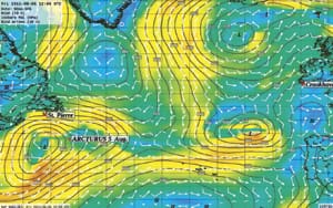
Sailing southeast was not part of our passage plan — we intended to go east, passing just south of Virgin Rocks on the Grand Banks and then putting a bit of north in our course and following the great circle route straight to Ireland. As it were, the wind would not let us go that way anyway. A low-pressure system was forming to the west of us, which had caught my dad’s attention early on, and looked to be tracking south of normal. By Aug. 5, we were well south of our intended course, getting light southerly winds to the east of the now-visible low. My father thought we could outrun its center, and get the westerlies south of it. On the Aug. 5 GRIB file (Fig. 1), you can see how far south the Azores High is — near 33° north — one of the reasons the approaching low was tracking farther south than we would have liked.
August 8, day 8
Three days later, the low had developed into a huge system spanning more than half the North Atlantic from west to east and some 1,500 miles north to south. We did manage to get on the correct side of it, and enjoyed three days of fast downwind sailing, recording three 24-hour runs in excess of 140 miles. But then, on the Aug. 8, we sailed directly into its center, and were becalmed in a horrendously confused sea. This marked the psychological low point of the trip for me. I was rousted from a fitful sleep with the sails slatting horribly, and scurried to the foredeck to stow the pole, cursing it all the while. Mia was on watch, the boat going nowhere despite her efforts at hand-steering in the light air, and the jib sheet block, situated exactly above my head, banged around enough to prevent any ideas I had of getting any sleep. Finally Mia called it quits, furled the sails and climbed into the bunk with me, trying to get some rest. Clint was sacked out too, so Mia set the alarm to go off every 30 minutes to look for ships and check the AIS.
Meanwhile, as you can see on the GRIBs for Aug. 8 (Fig. 2), to the south of us it was blowing west-southwest in the 20s. North of us, where we actually had planned to be on our great circle course, it was gusting to 30 and from the northeast. Farther north still showed winds of more than 40 knots, all easterly. Aboard Arcturus, after three phenomenal days of hull-speed broad-reaching, we had unwisely set the pole and sailed wing-on-wing, speeding downwind directly into the calm eye of the depression. Had we stayed higher on the wind on starboard jibe — and by doing so, keeping more to the south — we could have ridden the westerlies on the bottom of the low for perhaps a few more days.
August 13, day 13
After a harrowing attempt to set the gennaker in a brisk quartering wind on Aug. 10, the wind eased again and we were in light and variable wind for some days. Arcturus was stuck in an irregular area of high pressure, centered again way down near 33° north. We were closing in on our estimated halfway mark at the 32nd meridian (Fig. 3). “Mentally the last 24 hours have been a real challenge,” I wrote. “We change sails every few hours it seems, and the uncomfortable rolling during the calm spells could make for a legitimate form of torture.” By Aug. 13, another small low was forming far to our west, but on the weather map my father counted seven ‘H’s’ between North America and Europe. There was not much we could have done, north or south of our position, and would just have to uncomfortably wait out the weather.
August 19, day 19
Four days before our landfall, we finally had some fast downwind sailing, the type of conditions we had expected on our northerly crossing. Arcturus, sailing under her heavy small jib set to windward on the spinnaker pole, and the double-reefed mainsail out on the opposite side, was regularly surfing at more than 12 knots in the large following seas (Fig. 4). Since the halfway point, the days had gotten nicer, the sun coming out and warming the air enough that Mia donned her bikini and Clint and I were in board shorts. My midnight watch from 0000-0300 on the 20th was transcendent. We were bang on course, having just crossed the 20th meridian and sailing incredibly fast, double-digit surfing on every third or fourth wave. Polaris was high in the sky to port, and I noticed the Great Bear seemed bigger than I had ever seen him. Orion was on the rise, the sky so clear that he simply appeared over the black horizon. The air was crisp, but not too cool that I needed socks, and I remained in the cockpit barefoot.
The GRIBs indicated a nasty double-barrel depression far to our north, spanning the entire far-north Atlantic just south of Greenland, with northeasterly winds topping 50 knots near the notorious Cape Farewell. We were in a perfect spot to the southeast of the system’s two centers and riding the northwesterly wind straight towards Crookhaven. Dad had told us to stay near the 48th parallel to avoid the stronger winds to the north. Looking back at the GRIBs, this was perfect advice.
August 21, day 21
Arcturus had her best day’s run of 140 miles by 1800 on Aug. 21; the magnificent sailing continuing as we approached Europe. On the GRIBs at 1200 UTC on the 21st (Fig. 5), the low that gave us such good sailing the night before disappearing to the northeast. Behind it, and to the west of our position, an enormous area of high pressure began to fill in. Crossing 50° north was a big milestone for the crew. But it came with yet another calm, this time the longest of the voyage thus far, as the high moved east and overtook us. The wind died early in the morning on the 22nd, again during my 0000-0300 graveyard shift. We tried hand-steering and following the cats paws that morning, but they disappeared as the sun came up. It remained so dead flat calm that by noon that day the sea was a mirror. The heaving Atlantic swell, sometimes quieted but rarely silenced, was altogether gone. For 15 hours we drifted, watching dolphins play near the bow. Without the breeze to disturb the surface, the water was so clear we could see them some 30 feet down.
Finally, late on the 22nd, a low caught up with us (barely visible far to our northwest on the GRIBs for the 21st). The isobars extended just far south enough to give us fine sailing conditions, in 10 to 15 knots, for the duration of the sail to Crookhaven. We sighted land some 50 miles off at noon, and raced the sunset, finally anchoring after 23 days at sea, just as the sky darkened and the stars came out.
Conclusions
According to the August pilot charts and Jimmy Cornell’s book World Cruising Routes, we should have experienced westerly winds around 15 knots for most of our crossing. We ended up much farther south than the great circle route we had planned for, but in the end, we had to be there, as the depression track was more south than usual. Had we been farther north, particularly near the beginning of the crossing, we would have experienced strong easterlies.
The Azores High dominates the weather patterns in the north Atlantic during summer. It’s anticyclonic (clockwise) rotation sends depressions spinning off to the north of it, and the high’s position north or south more or less determines the tracks of these storms after they form on the eastern seaboard of North America (in conjunction with the cyclonic rotation of the Icelandic Low, the dominant feature farther north). It’s position east-west helps determine the track of tropical cyclones, and whether or not they will make landfall on the U.S. coast. A particularly large or strong low can disrupt this high, an example visible on the Aug. 8 GRIB image, showing the high split into western and eastern areas, with the enormous low squeezed in the middle.
The large areas of high pressure in the mid-Atlantic were situated to the south during the summer of 2011, sometimes near the 32nd parallel, thereby letting the lows slip farther south, and giving us the variable weather we experienced. As the summer progressed, the high moved north, and the lows intensified. By Aug. 19, the high had finally become more regular, and had moved north of 40° north. We were riding the bottom of a low by then — where it was supposed to be — and enjoying the best sailing of the trip.
On Sept. 10, long after Clint had left us, Mia and I were well into the Irish Sea, making our way up the east coast towards Belfast. The remnants of Hurricane Katia, still blowing in the 40s according to the GRIBs, were storming like a freight train across the north Atlantic. With a high-pressure centered at 35° north, the storm was following the more typical path and we were thankful not to be there.
The satphone weather routing worked excellently for us, most notably during the first part of the crossing. My dad had said ‘go south’ right off the bat, and it worked, actually panning out for the duration of the crossing. Had we stuck to the great circle route as planned, we would have had a totally different experience, and by the look of the GRIBs, I’m convinced a more uncomfortable one.
Oh, and if you don’t happen to have a dad eager to do weather routing for you, there are, of course, weather routing services who can be engaged to provide you with a variety of routing options.
Andy Schell is a freelance writer, a boat rigger and delivery captain along with his father. They are based in Annapolis, Md.