Bring a voyager forward in time from the 1950s and they would likely be amazed at the ease and instantaneous availability of navigation via GPS. A similar technological evolution is underway in the field of emergency signaling. EPIRBs and PLBs are on the verge of attaining a similar level of user friendliness and reliability as GPS. A key component of this evolution is a shift in the location of the listening stations to higher ground.
The first emergency position indicating radio beacons used the frequencies 121.5/243 MHz. A big part of the early EPIRB concept was the idea that aircraft such as commercial airliners would be available to pick up the 121.5-MHz emergency signal and then alert search-and-rescue forces. This aviation segment of early EPIRBs proved ineffective. The more important part of EPIRB emergency signal reception was the job performed by satellites. These satellites were in low polar orbits. For people in distress near the equator, an hour and a half could pass before a satellite was in position to receive an EPIRB distress signal. And the only way to determine the position of the EPIRB was via analysis of the Doppler shift of its transmitted signal.
This frequency-shift location method raised an important issue. Since Doppler shift analysis looks for the shift in frequency to determine the EPIRB’s position on the earth, in order to perform an accurate analysis, the EPIRB needed to broadcast a steady unwavering frequency. Early EPIRBS, however, were not manufactured to a rigorous standard and the frequency they transmitted sometimes slewed around a bit. The result was that sometimes SAR forces knew someone was in trouble, but the inaccuracy of the system meant SAR elements had a large area in which to search.
This problem was greatly reduced by the introduction of the 406-MHz frequency EPIRB. The 406-MHz transmitter specifications were more tightly written than the previous 121.5/243 standard. This means 406 EPIRBs broadcast a signal that allows for better Doppler analysis. The search area for a 406 EPIRB is smaller than for previous versions.
The next step was to place a GPS receiver into the 406-MHz EPIRB package. The GPS unit determines position and that information is encoded in the 406-MHz signal. So at this point we have an emergency signaling system that can accurately determine position via Doppler shift and via an embedded GPS position. The developments didn’t stop there, however.
A further improvement was to place SARSAT receiver packages onto a few geosynchronous communications satellites. Geo birds, of course, are 22,000 miles out and traveling at orbital velocity, so they seem to hang over one spot on the earth. This gives a geo satellite a view of nearly an entire hemisphere. Any 406 EPIRB that transmits in that coverage area will be picked up. The one drawback to using a geo sat, however, is that it is — by definition — not moving, so Doppler shift position-finding doesn’t work. The only way for SAR authorities to know the position of the EPIRB is if it has an embedded GPS unit.
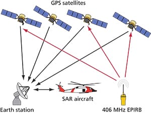
The next step beyond that was to find a satellite platform that was both moving in relation to the surface and at a high altitude so each satellite had a large view area. The solution was to use GPS satellites in medium earth orbit (MEO). They are 10,000 miles high and they also move in relation to the surface. Plus, there are 24 of them so their system coverage of the Earth is complete. And since multiple GPS satellites will be above the horizon at any one time, the Doppler shift of an EPIRB signal can be processed by two, three or four GPS satellites at once so the Doppler shift positioning will be more accurate. The SARSAT transponders on GPS satellites will also pick up GPS positions embedded in EPIRB signals.
To make the SARSAT system even more redundant and reliable, SARSAT transponders will also be placed on each replacement GLONASS satellite (the Russian satellite navigation system) and on each Galileo satellite (the European version of GPS). This approach is called MEOSAR and it should mean that EPIRBs will be as reliable as using GPS on your smartphone.
And there’s one more wrinkle that will be included on the European Galileo satellites. Those units will have the ability to not only receive EPIRB signals, but they will be able to send a “message received” return signal that will register on the EPIRB’s screen — a great sight if you’re sitting in a life raft.
Some EPIRB manufacturers are also adding AIS capability to their EPIRBs. McMurdo, for example, recently announced the “four frequency” Smartfind EPIRB. It supports 406 MHz, 121.5 MHz (121.5 is still used for localized homing), GPS and AIS. The AIS frequency lets nearby ships see you on their MFDs.