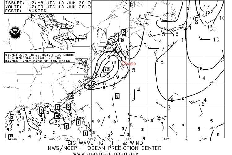
Voyager Peter Stoops is currently sailing the S&S designed Swan 40 Chase from the U.S. East Coast to the Azores. And they are anticipating a big storm catching them tonight. Here are Stoops’ comments delivered via Iridium satphone:
All battened down – looks like it may hit us earlier than expected, according to herb. So, don’t be surprised if you see us in one place, hove to. Forecast calls for storm conditions, sustained 40’s gusts into 50’s. have practiced with all sails and lines, and have cleaned up pretty good. Not like it wasn’t without warning. So, hopefully, come tomorrow pm we’ll turn the corner and head east – looking for strong sw going to nw. cooking right now on the east side of a warm eddy – 4.6 boat speed, 8.2 over the ground. So, that will help us get a bit further south which will help.
[Have] seen tons of whales, some dolphins, and a view of the milky way like I haven’t seen in years. No moon until 0200, when a little slice comes up, blood red. Looks like someone’s running light. AIS working perfectly – warned us of impending collision way early on with a tanker this a.m.
These guys are doing well – getting along well and pitching in. John cooking up a storm. All learning. We’ll see how it looks in 36 hours!
Ken McKinley of Locus Weather provides this analysis of Chase’s situation:
It looks like Chase will indeed take a pounding this evening and tonight, and probably tomorrow, too.
A fairly intense low is tracking east along about 40°N, and will continue this course through the next 48 hours, then it accelerate to the northeast later Sunday.
Satellite data shows the low center near 40°N/68°W at 1815 GMT this afternoon (2:15 PM EDT). It will likely pass about 64°W at 0000 GMT (8PM this evening), then will reach 60°W sometime around 1600 GMT tomorrow (noon EDT)
Winds through the late afternoon and into the early evening will be S or SSW at 32-38 knots with frequent gusts over 50 knots, and seas will be building to 12-16 feet. A cold front extending south from the low will pass the yacht near or a bit before 0000 GMT with a wind shift to W likely behind the front, and similar wind speeds. Later at night winds will veer to WNW and NW with speeds easing 26-31 knots, but gusts still near 40 knots. Seas will become confused with the wind shift, but will begin to subside a bit late at night. Frequent heavy squalls are likely ahead of the front, then partial clearing is likely behind the front.
Tomorrow winds will become more northerly as the low moves farther east, but with the low intensifying as it moves way, wind speeds will become stronger again, likely 30-35 knots with gusts over 40 knots at times. Seas will tend to run 10-15 feet through the day.
Wind speeds and seas will begin to ease a bit tomorrow night.
The most difficult conditions are likely to be ahead of the front due to the squalls, but the yacht will continue to deal with strong winds and heavy east through tomorrow.
The best strategy will be to endure the frontal passage, then to slow the boat down, perhaps heaving to for a while, or to head a bit more to the south (mainly to avoid going east). Letting the system run out ahead of the boat will allow the boat to see winds and seas diminish a bit earlier than would be the case if a continued easterly course was held, thus keeping the boat under the influence of the low longer.

