
Often you can explore the ocean by yourself but not at the 2,000-meter depths where strange and wonderful creatures live — like bacteria that feed on sulfur at deep ocean vents and are eaten by other animals. You need someone else to go down for you; for instance, the CAPSTONE expedition. It stands for Campaign to Address the Pacific monument Science, Technology and Ocean NEeds. Okeanos, an ocean research vessel run by NOAA, is on a three-year mission to explore deepwater U.S. marine protected areas in the Pacific using remotely operated vehicles and high-definition video cameras. This enables scientists on ships and shore to survey the bottom and water column without worrying about the logistics of sending humans down so deep. This year they’ve been in the Mariana Islands looking at seamounts. The dives are streamed live through the Ocean Explorer website, which means citizen scientists can follow as the expedition crew see things, sometimes for the first time ever.
This isn’t just another YouTube viewing. The expedition is conducted like an online chat room. On the ship Okeanos, two lead scientists run a play-by-play description of what the cameras show, direct the ROV crew based on their observations and those of scientists scattered around the world, and talk about fish and rocks and mud volcanoes when the action slows down. Sometimes we hear dive planning meetings where scientists and mappers go over the bathymetric pictures they used to choose a dive site, and identify or argue about new species. At the dive’s end, recorded video is streamed again so those like me can wake up the next day to finish off what we missed, but after that the website offers only highlights, which don’t have the personal touch and feeling of immediacy.
On screen, the bryozoans, crinoids and black corals bend their heads and wave bravely in the current; they look like flowers but there is no flora here. I have a lot of experience both snorkeling and scuba diving and in my excitement I talk to the screen, telling them, “There’s a fish!” or, “Pick up THAT rock!” It’s addicting. As I write I am waiting for 4:30 p.m. when the ROVs get underway; the dive starts a couple hours later when it reaches bottom and the lead scientists start their narration.
On Dive 3, Okeanos sent Deep Discoverer down 470 meters on the northeast flank of Maug Island in the Northern Marianas. The live feed was full of sea creatures, many with shapes similar to ones I’ve seen but in amazing colors and variations. The ROV’s lights flooded the ridge, the camera was calibrated to be accurate color-wise and the video zoomed inches from creatures, far closer than I get on a dive. I wondered what fish and octopus eyes made of the bright light. The shipboard crew documented Kulamanamana, a precious gold coral once used for jewelry now banned in Hawaii because of its rarity. It can live for thousands of years.
 |
|
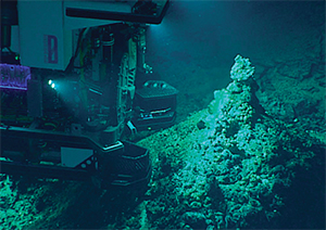
One of the ROVs on the bottom. |
|
NOAA |
The Mariana Islands sit near the eastern edge of the Mariana Plate where the Pacific Plate pushing underneath creates the Mariana Trench. The Challenger Deep here is the deepest place on earth at almost 11,000 meters. I once dropped a penny in the 8600-meter Puerto Rico Trench as we sailed over it and speculated how long would it take to reach the bottom.
Most people are going to armchair sail here, even experienced cruisers. The Pacific is a huge ocean scattered with island chains in a wide arc. Those at the northwest end don’t have the cache of the South Pacific and are far from the coconut milk run. Many were fought over in World War II. The Northern Mariana Islands are among the furthest flung, and perhaps least visited, but they are a U.S. Commonwealth with U.S. services and if you are a U.S. citizen there’s no limit on your stay.
Sailors stop in the islands occasionally before continuing on to Japan or the Philippines. The Marianas Yacht Club in Apra Harbor, Guam, has moorings for transient sailors and a welcoming membership and clubhouse. Supplies and services are generally available and re-provisioning is good, especially for U.S. foods. The Mariana Island chain runs 400 nm north along 145 degrees east longitude from Guam at 13 degrees north latitude through 14 Northern Mariana Islands that are mostly inactive volcanoes with few harbors or towns. Boats must stop in Saipan for entry permission to the Northern Marianas. The northern hemisphere trade winds meet the Asiatic Monsoon here. In winter the two weather patterns reinforce each other to produce steady northeast to east winds. In summer the winds may also come out of the south to west, and it’s rainy with thunderstorms. On average, one tropical storm per year originates in or passes over the Mariana Islands.
At the end of the dive at Maug, the Okeanos crew lifted Deep Discoverer off the bottom and cruised on to the next dive site overnight, a 6,000-meter ridge in the Mariana Trench itself — the deepest the ROV could go. Through September 2016 the ship continues in the Western Pacific, diving and mapping between sites including Wake Island, 1,300 nautical miles east of Guam and one of the most isolated islands in the world where there’s the potential to identify not only new life species but Underwater Cultural Heritage sites associated with World War II battles. The activity then shifts to the Central Pacific for 2017. You can follow each leg of the expedition live from the NOAA website.