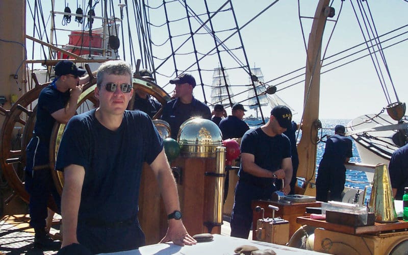
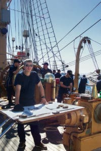
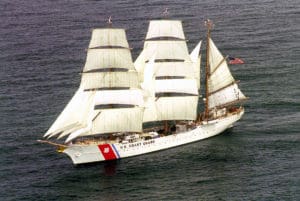
For the past 13 years, I have had the honor, and privilege, of serving as a qualified Quartermaster of the Watch (QMOW), on board the U.S. Coast Guard’s training vessel Eagle, a 295-foot square rigger (technically a barque) that serves as the Coast Guard’s primary platform for training cadets and officer candidates. In my capacity as QMOW, I stand navigational watches, and help to instruct the trainees in piloting, celestial and electronic navigation.
The Commanding Officers of Eagle have been big proponents of celestial navigation and like to offer challenges for the trainees. As an example, while on passage from Boston to Prince Edward Island, the vessel’s GPS units mysteriously “malfunctioned” and the cadets had to navigate Eagle by primarily using celestial navigation.
Since the cadets were being offered a challenge — GPS failure — I decided to up the ante for myself. What would we be able to do if, for example, the cadets dropped all the sextants overboard or, even more ominously, if we needed to suddenly abandon ship with no chance to gather any navigational instruments or references? Quite a bit, as it turns out. In fact, as long as you are wearing an accurate watch (ideally set to UTC time) and have
memorized a few key facts, it is possible to determine your position to within about 300 miles anywhere on the Earth.
Basic principles
In the standard reference on the subject, Emergency Navigation (available at starpath.com), the author, Dr. David Burch, explains a variety of techniques for instrument-free (or improvised instrument) based navigation. The following is a distillation of some of the techniques described in the book.
Determination of Latitude: In the Northern Hemisphere, the altitude (i.e., angle) of Polaris, above the horizon, is equal to your latitude. Although this is a bit of an approximation, for emergency navigation, the accuracy is more than adequate (well under a degree of imprecision). As long as Polaris can be identified, and as long as the horizon can be seen, then the altitude of Polaris — and thus your latitude — can be measured using your hands (see below).
Polaris is not visible in the Southern Hemisphere and nor is there an equivalent southern pole star. However, if you have memorized the declination of appropriate zenith stars (stars which will pass near or directly overhead), and you know how to identify them, then you can determine your latitude. The basic idea is that if a star passes directly overhead (i.e., at an altitude of 90 degrees) then its declination is your latitude. Even if a star does not pass directly overheard (the vast majority won’t), it is still possible to use it to calculate latitude: e.g., if a star passes 2 degrees south of your zenith, then your latitude is 2 degrees north of the declination of the star.
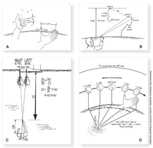
Measurement of Altitude (of Polaris or zenith stars): The gold standard for measuring altitude is, of course, the sextant. In an emergency, however, your hand can be used to measure angles within a reasonable degree of precision. Typical angles are as follows. (For each of these measurements, it is critical that your arm be fully extended.)
• Thickness of finger is approximately 2 degrees
• The distance between each of your knuckles is approximately 3 degrees
• If you wink, your finger will move by approximately 6 degrees
• A fist (with your thumb hidden) subtends an angle of approximately 10 degrees
• For an outstretched hand, the angle between your thumb and index finger is approximately 15 degrees
• For an outstretched hand, the angle between your thumb and pinky is approximately 20 degrees.
To increase precision, it’s possible to “calibrate” your body parts. One technique is to compare your subtended visual angles with the same angles determined by a sextant. Another option is to measure with a tape measure and use simple right angle trigonometry. Of course, this calibration would need to be done in advance of an emergency and the numbers memorized.
Determination of longitude: In order to determine longitude, it’s necessary to have an accurate watch. In this case, “accurate” means that the watch is either set to UTC (Greenwich Mean Time) or has a known offset from that time (e.g., a particular zone time). The basic idea is that, because the Earth is rotating on its axis, time is longitude, and longitude is time. In addition, the time of Local Apparent Noon (LAN) is the same along every meridian of longitude (e.g., LAN at 65 degrees west will occur at exactly the same time, regardless of your latitude).
Unfortunately, it is extremely difficult, if not impossible, to observe the time of LAN, even approximately, without suitable instruments (e.g., a sextant). However, it is relatively easy to observe the time of sunrise and sunset and, as long as you are not moving fast (which presumably would be the case in a life raft), then LAN is the arithmetic average of the time of sunrise and sunset.
The determination of your longitude is based on comparing your observed time of LAN (based on sunrise and sunset) against the predicted time of LAN. Due to tilt of the Earth’s axis, and the nature of the Earth’s rotation, LAN does not occur at exactly 1200 every day at Greenwich. In fact, the time of LAN will vary by as much as 16 minutes, depending upon the specific day. This difference is known as the equation of time, and daily values are listed in the Nautical Almanac. If you were in a lifeboat without the Nautical Almanac, would you be out of luck (at least navigationally speaking)? Not at all. In Emergency Navigation, a makeshift prescription for calculating the equation of time is provided, based on memorizing four key dates (Halloween and Valentine’s Day being two of them). The Barefoot Navigator (by Jack Lagan) also contains a poem (credited to Tony Crowley) to remember the dates: “14 minutes late around St. Valentine’s Day, 4 minutes early in the middle of May, 6 minutes late near the end of July, 16 minutes early when Halloween nigh, The differences last about two weeks, Around these pairs of troughs and peaks.”
Once you have “observed” the time of LAN (using the arithmetic average of sunrise and sunset) and calculated the predicted time of LAN (using either the Nautical Almanac, or the mnemonics above), the difference between them enables you to calculate the offset of your longitude from the prime meridian (one minute of time = 15 minutes of longitude).
Pragmatic considerations
It is, of course, best to learn and practice these techniques before they might be needed in an actual emergency. A number of pragmatic considerations will help to improve accuracy and safety.
• Due to “stacking” of clouds (i.e., looking through the atmosphere at a horizontal angle), it may be difficult to observe sunrise and sunset. However, as long as the time is measured with the sun at equal altitudes while rising and setting — e.g., a finger’s width above the horizon — the arithmetic average of the time will be LAN.
• When measuring angles with your hand, your arm must be fully extended.
• In general, the greatest accuracy in estimating altitudes (e.g., of Polaris) is when the objects are between approximately 5 degrees and 20 degrees above the horizon: below 5 degrees the objects may appear dimmer or be obscured by stacked clouds and above 20 degrees you will need to overlay multiple hand angles, thus increasing the likelihood of error.
• Do not stare directly at the sun — even when it is low on the horizon. Even with sunglasses, this could lead to serious vision loss. Quick peeks, however, in the general direction, are enough to determine the time of sunrise, or sunset.
• The technique for determining longitude works even if the watch is set to zone time (as opposed to Greenwich Time). In this case, the offset of longitude is applied to the zone’s standard meridian.
• For obvious reasons, it is important to know your watch error and compensate accordingly.
• I was not able to experiment with zenith star techniques — on Eagle, when you stand watch, you really are standing (lying on the deck is frowned upon). In general, the observation of zenith stars for latitude determination will be much more difficult than the observation of Polaris and it may well be necessary to lie down on the deck and observe for prolonged periods of time (e.g., an hour or more) before a zenith transit is observed. Moreover, a rough sea state may make these observations impossible.
This article originally appeared in the U.S. Coast Guard Auxiliary District 1SR Magazine Over The Bow (Spring 2021) ν
Steve Henkind, MD, PhD, is the president of SafeNav Marine, LLC in Tampa, Fla. He teaches navigation, sailing, and seamanship locally, nationally, and internationally.