Integrated performance systems that display inputs like wind direction, heading, depth, position, etc., have been available for decades. Most recently the multifunction display has become the go-to device for combining all that sensor data in one place. Now an Oxford, Nova Scotia-based company named iNav4U has released a product called Wayfinder that not only integrates the display of sensor information but goes a step further and uses rules-based artificial intelligence (AI) to analyze the data and provide warnings and make recommendations to the vessel operators about how to proceed.
Wayfinder was developed by Olivier Hendrikx, an experienced Swiss voyager who has sailed more than 100,000 nautical miles, including in the North Sea, Mediterranean, Atlantic, Cape Horn and across the South and North Pacific.
The impetus for Hendrikx to develop Wayfinder was his realization that boats were becoming ever more complex with multiple pieces of electronics, all of which provided their own stream of plentiful data to a boat’s operators. And in Hendrikx’s eyes this was leading to information overload. At one point in his exploration of this idea he spoke with an aerospace engineer who observed that pilots faced the same issue and that aircraft and avionics designers are always working on ways to reduce data overload and improve situational awareness.
“We should have the same for boats,” Hendrix said he thought at the time. “Something to diminish the workload.” According to Hendrikx this is what his new product does. “With Wayfinder you can really focus on the overall situation on the boat and also enjoy nature.”
Hendrikx had a longtime interest in software programming so as he sailed he began to automate many of the systems onboard his boat. His partner Brenda Robinson, who had experience with developing enterprise business software, saw the automation scheme that Hendrikx built and realized that he had a viable product. Together they launched iNav4U in 2015 to work on what would become Wayfinder.
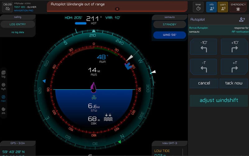
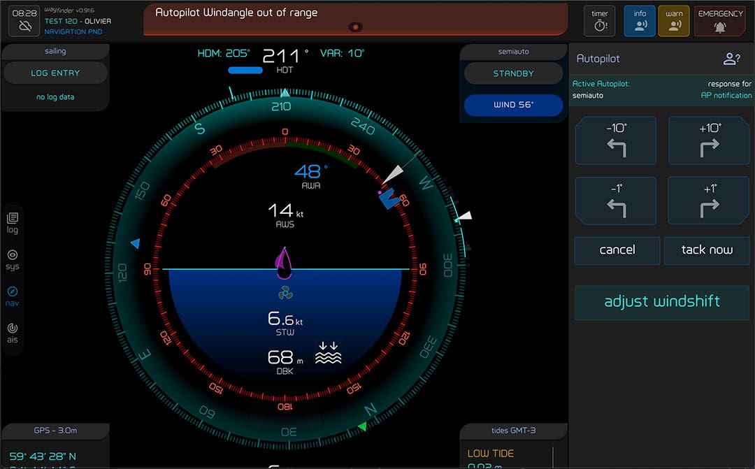
So how does Wayfinder integrate all the input from a boat’s sensors and other equipment? The company explains this to users by giving names to parts of its software, calling two of the modules the Analyzer and the Validator. These modules take the streams of data that arrive via NMEA 0183 and NMEA 2000 and then apply a set of hierarchical rules using what Hendrikx calls its rule engine. “The Wayfinder unit takes data and applies rules to it,” Hendrikx said. “The same way that any skipper makes decisions when sailing.” Then, should certain data be outside set parameters, the unit will advise the operator to take action. “The basic idea is that you don’t have to stare at the instruments,” Hendrikx said. “It diminishes the workload on your brain.”
The heart of Wayfinder is an aluminum black box that includes the brain chipset running on the Linux operating system. Also inside the box is built-in Wi-Fi and also various connectors for NMEA 0183, NMEA 2000, USB, Wi-Fi antennas and power. The unit can operate on either 12-volt or 24-volt DC.
While the brains of the Wayfinder system is its black box CPU, access by users is actually via web browser. Wayfinder puts all the data a user needs into the form of local network website with a distinctive 360 circular display of the data. Users can employ a browser on a smartphone, tablet, laptop or other browser-equipped Wi-Fi-capable device to interact with the system. Multiple users on board can access the Wayfinder screens anywhere on the boat. While Wayfinder does use the internet to download updates and send notifications via SMS, it doesn’t need to be connected to the internet to function — the AI rule engine runs autonomously.
The system has a long list of capabilities in addition to its central navigation and hardware integration functions including a continuously recording log book; anchoring support that takes into account depth data, freeboard, the amount of rode paid out, anchor position and anchor alarm; collision avoidance via AIS; sail management; engine monitoring; weather and tide data; emergency support; document management; automatically-generated repair lists and more. According to Hendrikx, Wayfinder’s weather capabilities are set to expand; and the software team will be adding a celestial navigation module for calculating sight reductions and determining an estimated position or fix.
Two intriguing examples of how Hendrikx has focused on the details is the way the system is set up to differentiate between salt water and fresh water in the bilge and its ability, should you lose GPS, to use AIS data from nearby vessels to triangulate your position.
Wayfinder has a price of $1,680 for the hardware and software, plus a $360 annual subscription for extended customer support. Currently, new Wayfinder buyers will receive six months customer support free.
As for Hendrikx and Robinson, once they get iNav4U running to their satisfaction, they plan to buy a boat and get back to voyaging again — no doubt assisted by some cockpit AI.