When a marine electronics concept achieves big success, it often migrates across multiple platforms and products until it becomes a nearly omnipresent part of the marine electronics environment. This happened with GPS and is now occurring with the automatic identification system (AIS). AIS is now embedded in multiple products and has grown far beyond its original implementation.
In its fledgling years, GPS, for example, was confined to bulky, dedicated receiver boxes. The screen on early GPS receivers gave you a readout in latitude and longitude. You had to manually plot the numbers on your paper chart — imagine that! Early receivers sometimes had only a single channel to receive GPS signals from the multiple satellites in view. The receiver had to lock onto one satellite at a time and work its way through each satellite solution before combining them into a fix. Eventually, receivers came onto the market with multiple channels so that signals from all the satellites in view could be received in parallel. GPS receivers also got ever smaller and were interfaced with chart plotters so that your position was presented on an electronic chart. No more hand plotting required.
Eventually, electronics companies managed to incorporate all the circuitry needed for a multichannel GPS on a single chip. This receiver on a chip technology allowed just about any marine electronics product to have its own onboard GPS capability. This is highly desirable for equipment like 406 MHz EPIRBs, for example. With an onboard GPS unit, the EPIRB can not only broadcast a homing signal but it can also send your GPS position to search and rescue units.
AIS has undergone a similar development. Initially, AIS was conceived as strictly an anticollision system for commercial vessels. The technical requirements for AIS were put forward by the Radio Technical Commission for Maritime (RTCM). The idea was for a VHF-based system that would allow the radios of ships to talk to each other while in range, providing info on each vessel’s name, position, heading and speed. This data would be number crunched by both radios and they would be able to determine if a risk of collision existed given that both vessels maintained their course and speed. In this way, AIS performs the same function as a human operator plotting positions on a radar screen or on a rapid radar plotting sheet and determining the closest point of approach (CPA) and the time of closest approach (TCPA). But the AIS system does this with no need for human intervention. (To be fair, radar systems have also been developed with automatic radar plotting aids that also can perform this function without a human operator needing to manually plot positions).
The technical details of AIS as devised by RTCM were tweaked as they went through the process of ratification by the UN’s International Maritime Organization (IMO) and became a worldwide standard. Under the Safety of Life at Sea (SOLAS) convention, IMO required all commercial vessels larger than 300 tons to carry and operate an AIS-equipped radio. These vessels were mandated to carry Class A AIS units with specific requirements for reporting times. Here’s the spec from the USCG AIS web page: “Class A stations report their position autonomously every 2-10 seconds dependent on the vessel’s speed and/or course changes (every three minutes or less when at anchor or moored); and, the vessel’s static and voyage related information every 6 minutes.”
A second class of AIS is a Class B unit: “Similar to Class A stations, they report every three minutes or less when at anchor or moored, but, their position is reported less often and at a lower power. Likewise, they report the vessel’s static data every 6 minutes, but, not any voyage related information.” Smaller vessels and yachts are most often equipped with Class B units.
But collision avoidance turns out to be only one application of AIS. Over time more uses have emerged for this automatic capability. AIS can be used for vessel tracking, an application that was greatly enhanced when it was determined that AIS signals could be received by satellite. This meant that marine commercial traffic for the whole globe could be received, assembled and displayed on a website (see MarineTraffic.com). The Coast Guard has investigated the possibility of attaching AIS units to Aids to Navigation like buoys, daymarks, and lighthouses.
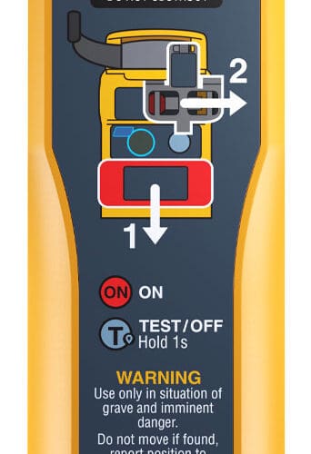
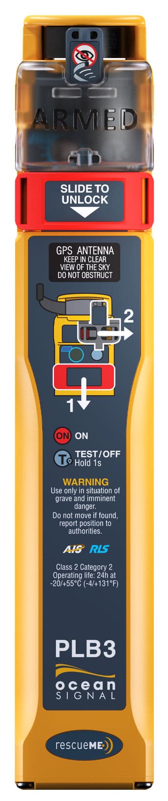
One of the more intriguing uses for AIS is in the field of safety. Devices like the McMurdo Smartfind, Ocean Signal RescueMe MOB1 and ACR AIS Link are all small AIS units that you attach to your life preserver. Should you go overboard, you activate the unit and it broadcasts an AIS signal that allows the crew on your boat to find and rescue you. Ocean Signal has also introduced the PLB3, which is a combined personal locator beacon (PLB, a small, personal EPIRB) and an AIS unit — it won the overall 2022 DAME award at the the big European marine show METS. The dual PLB/AIS capability not only alerts search and rescue services of an emergency but also allows the boat crew to home in on the person in the water. An application for AIS technology that likely was never contemplated when the system was first designed. What new applications of AIS will emerge in the years to come? n