My last newsletter spoke about the coming El Nino and its possible effects. An even earlier newsletter, “In Hawaii, Hurricanes Hardly Happen,” published one year ago at this time, talked about the relative infrequency of hurricanes in the vicinity of Hawaii.
In early August, not one, but two hurricanes affected the Hawaiian Islands. This is very uncommon, as indicated in the earlier newsletters. Let’s take a look at what happened.
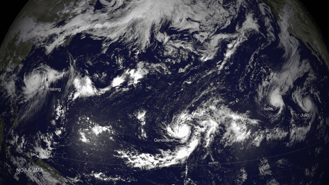
The first system to impact Hawaii was Iselle. This system formed as a tropical storm in the eastern Pacific on the last day of July more than 600 miles southwest of Cabo San Lucas, Mexico. It then tracked generally toward the west-northwest and became stronger, reaching hurricane strength on the 1st of August. It peaked in strength on August 4th as a category 3 hurricane, but was still about 1000 miles away from Hawaii. It continued west-northwest with very slow weakening through the next few days, dropping below hurricane strength just before making landfall on the Big Island on the evening of August 7th. The high mountains of the island caused major disruptions to its circulation and the system weakened quickly, becoming just a remnant low to the west of the Big Island within 24 hours of its landfall.
Even though Iselle had weakened to a tropical storm when its center made landfall, its circulation was still producing hurricane force winds when it began to impact the Big Island. Significant damage to buildings and infrastructure occurred due to the winds and also storm surge and large waves impacting the coast. Heavy rains produced significant flooding in many areas. Even though the storm weakened after moving over the Big Island, and its center remained south of the rest of the Hawaiian Islands, impacts of heavy rains and strong winds occurred on most of the other islands, although not as severe as on the Big Island.
The second system to impact the islands, although not as dramatically, was Julio. This system formed in the eastern Pacific as a tropical depression just a few days later than Iselle on the evening of August 3rd. It, too, strengthened while moving west-northwest and reached tropical storm strength early on August 4th, then became a hurricane early on August 6th. It peaked as a category 2 hurricane on August 8th, more than 600 miles west of the Big Island. It followed a track more to the north compared to Iselle, though, and passed north of the islands with its center never closer than about 250 miles. This meant that the impact for Julio was limited to large surf impacting the islands from the north, even though it maintained hurricane strength through this period. At this writing (August 13th) Julio was still classified as a hurricane (after a brief drop below hurricane strength) and was heading north in the central Pacific with an expected turn to the northeast accompanied by weakening and loss of tropical characteristics within a few days.
It’s worth exploring what allowed this unusual situation to evolve. The first place to look is El Nino. While it still appears that an El Nino will develop in the coming months, the data now seems to indicate that it may not be quite as strong as initially expected. Still, though, the sea surface temperatures in the eastern and central tropical North Pacific are running higher than normal at this time of year. Typically temperatures in the waters east of Hawaii at Hawaii’s latitude are not warm enough to sustain tropical cyclones, but they are this year. This allowed these systems which developed in the eastern Pacific to survive and even strengthen as they moved westward where in a typical year, they would weaken and dissipate over colder waters long before they reached Hawaii.
Interestingly, another system (Genevieve) that developed as a tropical storm in the eastern Pacific in late July moved west into the central Pacific and weakened, even losing its classification as a tropical cyclone for a time as it passed well south of Hawaii. The weakening was mainly due to unfavorable upper level winds, despite the fact that the sea surface temperatures along its track remained warm enough to support a tropical cyclone. In fact, it was likely the warm water temperatures which kept the system from dissipating entirely during this period, and it began to strengthen again as it approached the dateline, attaining hurricane strength early on August 6th and rapidly intensifying into a category four hurricane later the same day as it crossed the dateline. Once crossing the dateline, its classification changed to a typhoon, and it quickly strengthened to a super typhoon with sustained winds with sustained wind speeds of more than 140 knots. Slow weakening then occurred as it moved north over cooler waters through the ensuing several days.
In addition to the warmer than normal sea surface temperatures, the location and extent of the subtropical Pacific high has played a role in the systems affecting Hawaii this year. This high is typically centered northeast of Hawaii in the eastern Pacific most of the time, and in fact that has been the case this year as well. Often, though, a ridge extends west or west-southwest from the high just to the north of the Hawaiian Islands, and this tends to steer any tropical systems approaching from the east to the south of the island chain. Over the past month or so, the high center has been a bit farther north than usual, and also has not extended as far west as usual. This has created a steering pattern, which along with the warmer water temperatures, has allowed the systems to approach Hawaii.
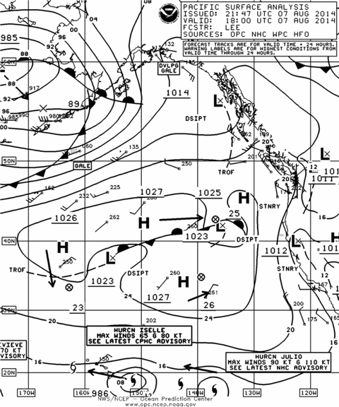
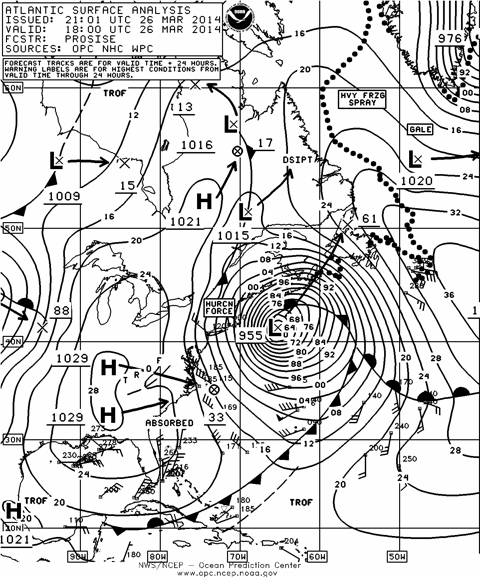
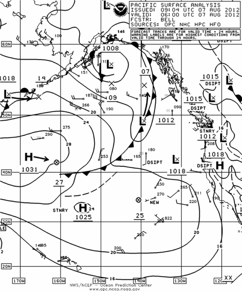
This can be illustrated by looking at Figure 1, which is the surface chart for August 7th of this year, showing the high center near 35° N to the northeast of Hawaii, and also showing both Iselle and Julio. Compare this to figure 2, which is a chart from the same date last year. Notice the more southern location of the high center, and also that its circulation extended farther west. Notice also that hurricane Henriette appears on this chart. After moving east-northeast for a very short time after the valid time of this chart, Henriette then moved west-southwest due to the presence of the high, and weakened (moving over colder water) while passing well south of Hawaii, and was classified as just a tropical depression once it reached the longitude of the Big Island. Figure 3 is a chart from the same date in 2012 and shows an even more extensive Pacific high with its circulation extending farther south, and there was very little tropical cyclone activity in the central Pacific during that season.
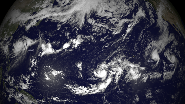
And finally, since a picture is worth a thousand words, Figure 4 is a satellite photo from August 6, 2014 which shows Iselle and Julio to the east of Hawaii, and also Genevieve off to the west near the dateline. In addition, at the same time, Typhoon Halong was moving north in the western Pacific, having weakened from super Typhoon status a few days earlier.
