The title of this newsletter sounds a bit like a medical device or a healthcare plan, but it actually refers to a weather system that can form in the Mediterranean Sea and cause strong winds, heavy rains and very rough seas.
The term is derived from a combination of “Mediterranean” and “hurricane.” True hurricanes do not form in the Mediterranean Sea because the conditions required for their formation (extensive areas of warm sea surface temperatures, uniform and light winds through the entire atmosphere, upper level outflow and surface convergence) rarely all exist together, and even if the conditions did coincide, the proximity of land surrounding all portions of the Mediterranean would mean that any system that began to develop would encounter land in fairly short order, and its development would be cut off.
Once in a while, however, conditions are favorable for a subtropical storm to develop. Subtropical storms have some characteristics of tropical cyclones but also some characteristics of mid-latitude lows, so they are a hybrid type of system. Like tropical cyclones, subtropical storms generally form within one air mass and as a result usually have no fronts, though at their initial formation there may be some slight contrast in air masses present and thus some weak fronts in their vicinity. The size of subtropical storms is similar to that of tropical cyclones. The main difference between subtropical storms and tropical cyclones has to do with their upper level structure and their method of development.
Tropical cyclones typically begin with a surface disturbance that initiates upward motion leading to thunderstorms; if all of the conditions above are met, then the upward motion will be sustained, surface pressures will become lower and the rotary circulation of the system will develop as it moves along within the overall atmospheric flow. The rising air in the center of the system will lead to significant release of latent heat as water vapor condenses, and the system will have a warm core at upper levels.
A subtropical storm typically develops underneath a nearly stationary upper level low, which represents a region of colder air. If the upper level low remains over warm water long enough, its circulation will work down to the surface and lead to a low developing at the surface. This will lead to upward motion that will promote shower and thunderstorm development, and so the subtropical storm will have a cold core aloft. When these systems develop over open ocean with plenty of warm water — and if they persist long enough — they often will transform into a warm core system by either moving away from the upper low or by the upper low weakening and dissipating, therefore transitioning to a tropical cyclone. In fact, this has happened several times in the Atlantic during the 2018 hurricane season with tropical storms Debby, Ernesto and Joyce as well as Hurricane Leslie all starting out as subtropical storms.
As noted above, subtropical storm development can occur at times in the Mediterranean provided that an upper level low stalls in the right place, meaning over open water away from land. There are only a couple of spots in the Mediterranean where the expanse of water is large enough for this to occur, and this development is most likely to occur in the late summer and early autumn when water temperatures are warmest. Unlike the open ocean, if these systems begin to move, they will generally run into land fairly quickly, so there is no opportunity for them to transform into tropical cyclones. However, a subtropical storm can still produce tropical storm-force winds, and because they bear a resemblance to tropical cyclones, the colloquial term “Medicane” has been coined when these systems occur over the Mediterranean.
 |
|
Figure 1: Surface pressure chart valid at 0000 UTC 28 September 2018. |
|
Source: UK Met Office |
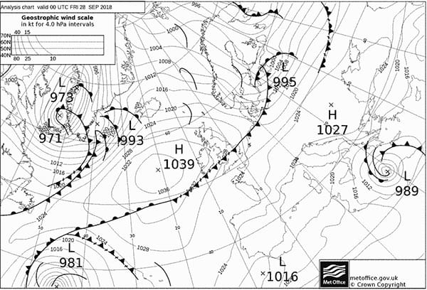
One of these “Medicanes” developed in late September of 2018 southeast of Sardinia and north of northeastern Libya in the Ionian Sea region of the Mediterranean. Figure 1 is a surface chart showing the system at 0000 UTC on Sept. 28. The central pressure of the system is indicated as 989 millibars, and though the chart shows a couple of fronts within the circulation, they are not connected to the center of the system. This indicates that there is little air mass contrast near the center. The isobars are nearly circular — similar to a tropical system — and the system is not very large, though the pressure gradient around it (as indicated by the tight spacing between isobars) is rather steep. Figure 2 is a surface chart 24 hours later, this time showing no fronts within the system. The system is not quite as deep as in Figure 1, but the tight circular pattern of the isobars is still evident. The system moved very slowly for the 24-hour period between the two charts. It eventually turned northeast through the subsequent two days, moving across southern Greece and into the northern Aegean Sea.
 |
|
Figure 2: Surface pressure chart valid at 0000 UTC 29 September 2018. |
|
Source: UK Met Office |
 |
|
Figure 3: Satellite image from 1200 UTC 28 September 2018. |
Figure 3 is a satellite image from 1200 UTC on Sept. 28, so halfway between the two surface charts in Figures 1 and 2. This image clearly shows the circular circulation pattern and the bands of precipitation surrounding the system, very similar to the precipitation pattern of a tropical cyclone. Figure 4 is a satellite image from 0900 UTC on Sept. 29, and by that time the cloud pattern is not as symmetric with most solid cloud north of the center. The circular pattern can still be seen extending south to the coast of Libya even though the cloud cover is much less extensive than to the north. At this time the circulation of the system was interacting with land, so it was beginning to weaken. And finally, Figure 5 is an ASCAT image showing the satellite-derived wind field at about the same time as the satellite image in Figure 4. The center of the system is clearly visible just southwest of the Peloponnesus of Greece, and the circular wind pattern with no abrupt wind shifts (due to the absence of fronts) is typical of a subtropical storm.
 |
|
Figure 4: Satellite image from 0900 UTC 29 September 2018. |
 |
|
Figure 5: ASCAT image from 0852 UTC 29 September 2018 showing satellite derived wind speed and direction. |
This system produced sustained winds near 50 knots with higher gusts for several days in this portion of the Mediterranean that led to seas building to more than 15 feet. In addition, heavy rains and strong winds caused damage over portions of Greece and western Turkey.

